![](/images/other/stat-length.png)
![Trail Running Ventavon - Pic de Crigne-Col des Selles - Photo](https://media.geolcdn.com/t/1900/400/ext.pjpeg?maxdim=2&url=https%3A%2F%2Fservices.sitytrail.com%2FGeolivesWS%2FDownloadMedia.ashx%3FTrailID%3D224673%26Media%3D20131001110258.jpg)
Pic de Crigne-Col des Selles
© OpenStreetMap contributors
![Running](https://static1.geolcdn.com/sitytour/trail-icons/103.png)
Running
4h22
Difficulty : Medium
![Length](/images/other/stat-length.png)
Length
18.5 km
![Max alt](https://static1.geolcdn.com/siteimages/upload/files/1508320355ic_sort_altitude_max_24dp.png)
Max alt
1355 m
![Uphill gradient](https://static1.geolcdn.com/siteimages/upload/files/1508320355ic_sort_den_pos_24dp.png)
Uphill gradient
1069 m
![Km-Effort](/images/other/stat-length.png)
Km-Effort
33 km
![Min alt](https://static1.geolcdn.com/siteimages/upload/files/1508320355ic_sort_altitude_min_24dp.png)
Min alt
574 m
![Downhill gradient](https://static1.geolcdn.com/siteimages/upload/files/1508320355ic_sort_den_neg_24dp.png)
Downhill gradient
1067 m
![Boucle](https://static1.geolcdn.com/siteimages/upload/files/16400158638029165_repeat_loop_refresh_sync_direction_icon.png)
Boucle
Yes
Creation date :
2014-12-10 00:00:00.0
Updated on :
2014-12-10 00:00:00.0
![Running](https://static1.geolcdn.com/sitytour/trail-icons/103.png)
4h22
Difficulty : Medium
![Scan this QR Code to open this trail in the SityTrail application](https://capi.geolives.com/qq0zvz2zws4bq2lad0pu/sitytour/trails/224673/qr.png?size=200)
FREE GPS app for hiking
About
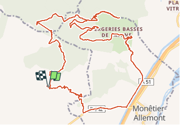
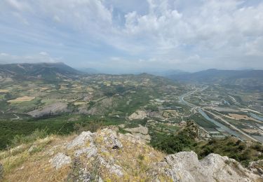
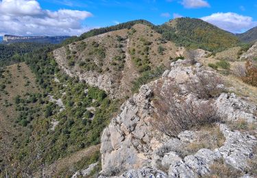
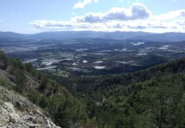
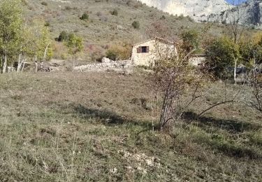
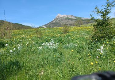
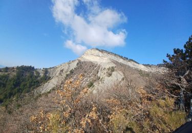
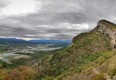
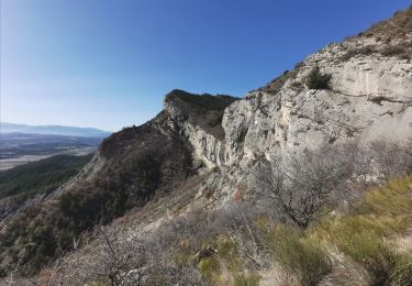
Trail Running of 18.5 km to be discovered at Provence-Alpes-Côte d'Azur, Hautes-Alpes, Ventavon. This trail is proposed by frederique.marti@laposte.net.
Description
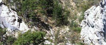
Pour atteindre le sommet c'est très chaud... Les derniers 400m semblent particulièrement dangereux. Je me suis abstenu, ayant eu connaissance de chutes mortelles...!
Points of interest
Positioning
Country:
France
Region :
Provence-Alpes-Côte d'Azur
Department/Province :
Hautes-Alpes
Municipality :
Ventavon
Location:
Unknown
Start:(Dec)
Start:(UTM)
731692 ; 4919539 (31T) N.
Comments
Trails nearby
![Trail Walking Monêtier-Allemont - le pic de Crigne - Photo](https://media.geolcdn.com/t/375/260/3216e3ac-fa23-434c-aac1-d06a9982e5b1.jpg&format=jpg&maxdim=2)
![Walking Walking](https://static1.geolcdn.com/sitytour/trail-icons/101.png)
le pic de Crigne
Walking
Difficult
Monêtier-Allemont,
Provence-Alpes-Côte d'Azur,
Hautes-Alpes,
France
![](/images/other/stat-length.png)
5.6 km | 13.4 km-effort
3h 27min
![](https://static1.geolcdn.com/siteimages/upload/files/16400158638029165_repeat_loop_refresh_sync_direction_icon.png)
Yes
![Trail Walking Vitrolles - Pic de Crigne - Photo](https://media.geolcdn.com/t/375/260/8de24f96-abb9-4a59-92c3-86b70c658bb0.jpg&format=jpg&maxdim=2)
![Walking Walking](https://static1.geolcdn.com/sitytour/trail-icons/101.png)
Pic de Crigne
Walking
Medium
Vitrolles,
Provence-Alpes-Côte d'Azur,
Hautes-Alpes,
France
![](/images/other/stat-length.png)
5.9 km | 14.3 km-effort
3h 14min
![](https://static1.geolcdn.com/siteimages/upload/files/16400158638029165_repeat_loop_refresh_sync_direction_icon.png)
Yes
![Trail Walking Ventavon - col des selles vers pic de crigne - Photo](https://media.geolcdn.com/t/375/260/e38de5f2-bcbf-465e-9709-6640d810ac1b.jpg&format=jpg&maxdim=2)
![Walking Walking](https://static1.geolcdn.com/sitytour/trail-icons/101.png)
col des selles vers pic de crigne
Walking
Medium
Ventavon,
Provence-Alpes-Côte d'Azur,
Hautes-Alpes,
France
![](/images/other/stat-length.png)
8.3 km | 17.3 km-effort
4h 4min
![](https://static1.geolcdn.com/siteimages/upload/files/16400158638029165_repeat_loop_refresh_sync_direction_icon.png)
Yes
![Trail Walking Monêtier-Allemont - pic de Crigne - Photo](https://media.geolcdn.com/t/375/260/4385029e-383e-41cf-87d5-306f1333b6ec.jpg&format=jpg&maxdim=2)
![Walking Walking](https://static1.geolcdn.com/sitytour/trail-icons/101.png)
pic de Crigne
Walking
Medium
Monêtier-Allemont,
Provence-Alpes-Côte d'Azur,
Hautes-Alpes,
France
![](/images/other/stat-length.png)
11.3 km | 23 km-effort
6h 23min
![](https://static1.geolcdn.com/siteimages/upload/files/16400158638029165_repeat_loop_refresh_sync_direction_icon.png)
Yes
![Trail Walking Ventavon - VENTAVON lac de Peysier n - Photo](https://media.geolcdn.com/t/375/260/07c33526-230f-4d24-9430-dca2c4faa349.jpg&format=jpg&maxdim=2)
![Walking Walking](https://static1.geolcdn.com/sitytour/trail-icons/101.png)
VENTAVON lac de Peysier n
Walking
Medium
Ventavon,
Provence-Alpes-Côte d'Azur,
Hautes-Alpes,
France
![](/images/other/stat-length.png)
9.3 km | 16.7 km-effort
2h 53min
![](https://static1.geolcdn.com/siteimages/upload/files/16400158638029165_repeat_loop_refresh_sync_direction_icon.png)
Yes
![Trail Walking Ventavon - VENTAVON . crête de Colombier , roc de l Escubier o m s - Photo](https://media.geolcdn.com/t/375/260/eb2996c2-264a-421d-8745-31a34e3b5708.jpg&format=jpg&maxdim=2)
![Walking Walking](https://static1.geolcdn.com/sitytour/trail-icons/101.png)
VENTAVON . crête de Colombier , roc de l Escubier o m s
Walking
Difficult
Ventavon,
Provence-Alpes-Côte d'Azur,
Hautes-Alpes,
France
![](/images/other/stat-length.png)
12 km | 21 km-effort
4h 11min
![](https://static1.geolcdn.com/siteimages/upload/files/16400158638029165_repeat_loop_refresh_sync_direction_icon.png)
Yes
![Trail Walking Vitrolles - Pic de Crigne - Photo](https://media.geolcdn.com/t/375/260/c57ec1d9-7b0a-459e-886f-cd7864baade1.jpg&format=jpg&maxdim=2)
![Walking Walking](https://static1.geolcdn.com/sitytour/trail-icons/101.png)
Pic de Crigne
Walking
Very difficult
Vitrolles,
Provence-Alpes-Côte d'Azur,
Hautes-Alpes,
France
![](/images/other/stat-length.png)
11.6 km | 21 km-effort
5h 33min
![](https://static1.geolcdn.com/siteimages/upload/files/16400158638029165_repeat_loop_refresh_sync_direction_icon.png)
No
![Trail Walking Monêtier-Allemont - SityTrail - Pic de Crigne. - Photo](https://media.geolcdn.com/t/375/260/e57e7c6e-7b24-471d-a732-1162a0342581.jpg&format=jpg&maxdim=2)
![Walking Walking](https://static1.geolcdn.com/sitytour/trail-icons/101.png)
SityTrail - Pic de Crigne.
Walking
Medium
Monêtier-Allemont,
Provence-Alpes-Côte d'Azur,
Hautes-Alpes,
France
![](/images/other/stat-length.png)
4 km | 8.9 km-effort
2h 0min
![](https://static1.geolcdn.com/siteimages/upload/files/16400158638029165_repeat_loop_refresh_sync_direction_icon.png)
Yes
![Trail Walking Claret - Tete de Boursier depart Claret - Photo](https://media.geolcdn.com/t/375/260/c93a942b-9518-4b3c-80a9-c6f6ef8e8c48.jpg&format=jpg&maxdim=2)
![Walking Walking](https://static1.geolcdn.com/sitytour/trail-icons/101.png)
Tete de Boursier depart Claret
Walking
Medium
Claret,
Provence-Alpes-Côte d'Azur,
Alpes-de-Haute-Provence,
France
![](/images/other/stat-length.png)
12 km | 22 km-effort
5h 32min
![](https://static1.geolcdn.com/siteimages/upload/files/16400158638029165_repeat_loop_refresh_sync_direction_icon.png)
Yes