![](/images/other/stat-length.png)
![Trail Walking Orry-la-Ville - Au pays du margotin _ 5,9 km - Photo](https://media.geolcdn.com/t/1900/400/ext.pjpeg?maxdim=2&url=https%3A%2F%2Fstatic1.geolcdn.com%2Fsiteimages%2Fupload%2Ffiles%2F1553511878bg_sport_marche.png)
Au pays du margotin _ 5,9 km
Pousscailleux
User
![Length](/images/other/stat-length.png)
Length
5.9 km
![Max alt](https://static1.geolcdn.com/siteimages/upload/files/1508320355ic_sort_altitude_max_24dp.png)
Max alt
134 m
![Uphill gradient](https://static1.geolcdn.com/siteimages/upload/files/1508320355ic_sort_den_pos_24dp.png)
Uphill gradient
91 m
![Km-Effort](/images/other/stat-length.png)
Km-Effort
7.1 km
![Min alt](https://static1.geolcdn.com/siteimages/upload/files/1508320355ic_sort_altitude_min_24dp.png)
Min alt
65 m
![Downhill gradient](https://static1.geolcdn.com/siteimages/upload/files/1508320355ic_sort_den_neg_24dp.png)
Downhill gradient
91 m
![Boucle](https://static1.geolcdn.com/siteimages/upload/files/16400158638029165_repeat_loop_refresh_sync_direction_icon.png)
Boucle
Yes
Creation date :
2014-12-10 00:00:00.0
Updated on :
2014-12-10 00:00:00.0
![Walking](https://static1.geolcdn.com/sitytour/trail-icons/101.png)
1h33
Difficulty : Easy
![Scan this QR Code to open this trail in the SityTrail application](https://capi.geolives.com/qq0zvz2zws4bq2lad0pu/sitytour/trails/223297/qr.png?size=200)
FREE GPS app for hiking
About
Trail Walking of 5.9 km to be discovered at Hauts-de-France, Oise, Orry-la-Ville. This trail is proposed by Pousscailleux.
Description
Départ du parking de la gare de Coye la Forêt.
Les margotins étaient des petits fagots de bois destinés aux parisiens pendant la guerre 14-18 provenant de cette partie de la foret de Coye.
Positioning
Country:
France
Region :
Hauts-de-France
Department/Province :
Oise
Municipality :
Orry-la-Ville
Location:
Unknown
Start:(Dec)
Start:(UTM)
462742 ; 5443000 (31U) N.
Comments
Trails nearby
![Trail Walking Orry-la-Ville - Dans la forêt des moines - Orry-la-Ville - Photo](https://media.geolcdn.com/t/375/260/ext.jpg?maxdim=2&url=https%3A%2F%2Fservices.sitytrail.com%2FGeolivesWS%2FDownloadMedia.ashx%3FTrailID%3D112753%26Media%3D11974_6.jpg)
![Walking Walking](https://static1.geolcdn.com/sitytour/trail-icons/101.png)
Dans la forêt des moines - Orry-la-Ville
Walking
Medium
(2)
Orry-la-Ville,
Hauts-de-France,
Oise,
France
![](/images/other/stat-length.png)
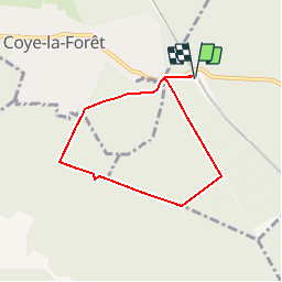
9.2 km | 11.2 km-effort
2h 30min
![](https://static1.geolcdn.com/siteimages/upload/files/16400158638029165_repeat_loop_refresh_sync_direction_icon.png)
Yes
![Trail Walking Coye-la-Forêt - SM_COYE la FORET_7.9Km - Photo](https://media.geolcdn.com/t/375/260/2c7f88d5-a8c7-4a01-b898-2562006c8bcb.jpg&format=jpg&maxdim=2)
![Walking Walking](https://static1.geolcdn.com/sitytour/trail-icons/101.png)
SM_COYE la FORET_7.9Km
Walking
Medium
(5)
Coye-la-Forêt,
Hauts-de-France,
Oise,
France
![](/images/other/stat-length.png)
7.9 km | 10 km-effort
2h 40min
![](https://static1.geolcdn.com/siteimages/upload/files/16400158638029165_repeat_loop_refresh_sync_direction_icon.png)
Yes
![Trail Walking Orry-la-Ville - SM_MONTGRESIN_EST_8.2Km - Photo](https://media.geolcdn.com/t/375/260/311cd4bc-107d-4955-a31f-0f6e6e4d5e34.jpg&format=jpg&maxdim=2)
![Walking Walking](https://static1.geolcdn.com/sitytour/trail-icons/101.png)
SM_MONTGRESIN_EST_8.2Km
Walking
Medium
(6)
Orry-la-Ville,
Hauts-de-France,
Oise,
France
![](/images/other/stat-length.png)
8.2 km | 9.2 km-effort
1h 51min
![](https://static1.geolcdn.com/siteimages/upload/files/16400158638029165_repeat_loop_refresh_sync_direction_icon.png)
Yes
![Trail Walking Pontarmé - MR_PONTARME-OUEST_4.9Km - Photo](https://media.geolcdn.com/t/375/260/dbbf6bf6-6d64-4082-9691-d7914590c7ad.jpg&format=jpg&maxdim=2)
![Walking Walking](https://static1.geolcdn.com/sitytour/trail-icons/101.png)
MR_PONTARME-OUEST_4.9Km
Walking
Easy
(2)
Pontarmé,
Hauts-de-France,
Oise,
France
![](/images/other/stat-length.png)
4.9 km | 5.5 km-effort
1h 12min
![](https://static1.geolcdn.com/siteimages/upload/files/16400158638029165_repeat_loop_refresh_sync_direction_icon.png)
Yes
![Trail Walking Pontarmé - SM_PONTARME_EST(Chateau)_8.6Km - Photo](https://media.geolcdn.com/t/375/260/b81fa35c-5ff8-4c16-a667-6e34ad7ac051.jpg&format=jpg&maxdim=2)
![Walking Walking](https://static1.geolcdn.com/sitytour/trail-icons/101.png)
SM_PONTARME_EST(Chateau)_8.6Km
Walking
Medium
(6)
Pontarmé,
Hauts-de-France,
Oise,
France
![](/images/other/stat-length.png)
8.6 km | 9.7 km-effort
2h 9min
![](https://static1.geolcdn.com/siteimages/upload/files/16400158638029165_repeat_loop_refresh_sync_direction_icon.png)
Yes
![Trail Walking Luzarches - Autour d'Orry la Ville - Photo](https://media.geolcdn.com/t/375/260/ext.jpg?maxdim=2&url=https%3A%2F%2Fservices.sitytrail.com%2FGeolivesWS%2FDownloadMedia.ashx%3FTrailID%3D110190%26Media%3D5411_1.jpg)
![Walking Walking](https://static1.geolcdn.com/sitytour/trail-icons/101.png)
Autour d'Orry la Ville
Walking
Medium
(1)
Luzarches,
Ile-de-France,
Val-d'Oise,
France
![](/images/other/stat-length.png)
22 km | 26 km-effort
4h 25min
![](https://static1.geolcdn.com/siteimages/upload/files/16400158638029165_repeat_loop_refresh_sync_direction_icon.png)
Yes
![Trail Walking Orry-la-Ville - La forêt des étangs de Comelle - Orry la Ville - Photo](https://media.geolcdn.com/t/375/260/ext.jpg?maxdim=2&url=https%3A%2F%2Fservices.sitytrail.com%2FGeolivesWS%2FDownloadMedia.ashx%3FTrailID%3D106559%26Media%3D11129_1.jpg)
![Walking Walking](https://static1.geolcdn.com/sitytour/trail-icons/101.png)
La forêt des étangs de Comelle - Orry la Ville
Walking
Medium
(1)
Orry-la-Ville,
Hauts-de-France,
Oise,
France
![](/images/other/stat-length.png)
11.4 km | 13 km-effort
4h 0min
![](https://static1.geolcdn.com/siteimages/upload/files/16400158638029165_repeat_loop_refresh_sync_direction_icon.png)
Yes
![Trail Walking Fosses - Boucle Survilliers - St Witz - Moussy le neuf - Plailly 25 km - Photo](https://media.geolcdn.com/t/375/260/6acc754b-b0c4-4c8e-9dba-f497fb8b1c3a.jpg&format=jpg&maxdim=2)
![Walking Walking](https://static1.geolcdn.com/sitytour/trail-icons/101.png)
Boucle Survilliers - St Witz - Moussy le neuf - Plailly 25 km
Walking
Medium
Fosses,
Ile-de-France,
Val-d'Oise,
France
![](/images/other/stat-length.png)
26 km | 30 km-effort
5h 27min
![](https://static1.geolcdn.com/siteimages/upload/files/16400158638029165_repeat_loop_refresh_sync_direction_icon.png)
Yes
![Trail Walking Orry-la-Ville - FORET DE COYE BOUCLE 16 KM - Photo](https://media.geolcdn.com/t/375/260/ext.jpg?maxdim=2&url=https%3A%2F%2Fstatic1.geolcdn.com%2Fsiteimages%2Fupload%2Ffiles%2F1553511878bg_sport_marche.png)
![Walking Walking](https://static1.geolcdn.com/sitytour/trail-icons/101.png)
FORET DE COYE BOUCLE 16 KM
Walking
Very difficult
(1)
Orry-la-Ville,
Hauts-de-France,
Oise,
France
![](/images/other/stat-length.png)
16.3 km | 19.4 km-effort
4h 23min
![](https://static1.geolcdn.com/siteimages/upload/files/16400158638029165_repeat_loop_refresh_sync_direction_icon.png)
No