Chamuera SityTrail > Trails > Outdoor > Switzerland > Grisons > Maloja > La Punt Chamues-ch SityTrail > Trails > Outdoor > Switzerland > Grisons > Maloja > La Punt Chamues-ch Chamuera hallauer User 3D © OpenStreetMap contributors Length 10.8 km Max alt 2301 m Uphill gradient 143 m Km-Effort 14.7 km Min alt 1686 m Downhill gradient 748 m Boucle No Creation date : 2014-12-11 00:00:00.0 Updated on : 2014-12-11 00:00:00.0 (0 Reviews) Other activity -- Difficulty : Unknown FREE GPS app for hiking SityTrail IGN / Geographical institutes SityTrail World The world is yours! About 
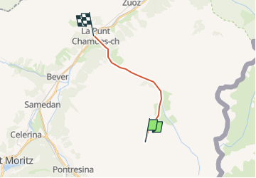
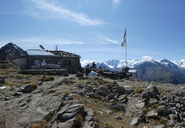
Trail Other activity of 10.8 km to be discovered at Grisons, Maloja, La Punt Chamues-ch. This trail is proposed by hallauer. Description Schöne Wanderung Legends | More details (PDF) Elevation profile Legends > 15% 15% - 10% 10% - 5% flat 5% - 10% 10% - 15% 15% - 30% > 30% Positioning Country: Switzerland Region : Grisons Department/Province : Maloja Municipality : La Punt Chamues-ch Location: Unknown Start:(Dec) 46.508474 / 9.974421 Start:(UTM) 574757 ; 5151006 (32T) N. Comments Please log in to post a review or rate the element Trails nearby GUIDE+ Muottas Muragl - Chna. Segantini On foot Easy Samedan, Grisons, Maloja, Switzerland 3.4 km | 5.8 km-effort 1h 18min No GUIDE+ y10_muottas_muragl Other activity Very easy Pontresina, Grisons, Maloja, Switzerland 11.7 km | 22 km-effort 5h 1min No GUIDE+ hike06 Walking Very easy Pontresina, Grisons, Maloja, Switzerland 6.6 km | 10.4 km-effort Unknown No