![](/images/other/stat-length.png)
![Trail Walking Lège-Cap-Ferret - Lège-Cap Ferret, réserve des près d'Arès 20 km - Photo](https://media.geolcdn.com/t/1900/400/ext.pjpeg?maxdim=2&url=https%3A%2F%2Fstatic1.geolcdn.com%2Fsiteimages%2Fupload%2Ffiles%2F1553511878bg_sport_marche.png)
Lège-Cap Ferret, réserve des près d'Arès 20 km
YV24
User
![Length](/images/other/stat-length.png)
![Max alt](https://static1.geolcdn.com/siteimages/upload/files/1508320355ic_sort_altitude_max_24dp.png)
![Uphill gradient](https://static1.geolcdn.com/siteimages/upload/files/1508320355ic_sort_den_pos_24dp.png)
![Km-Effort](/images/other/stat-length.png)
![Min alt](https://static1.geolcdn.com/siteimages/upload/files/1508320355ic_sort_altitude_min_24dp.png)
![Downhill gradient](https://static1.geolcdn.com/siteimages/upload/files/1508320355ic_sort_den_neg_24dp.png)
![Boucle](https://static1.geolcdn.com/siteimages/upload/files/16400158638029165_repeat_loop_refresh_sync_direction_icon.png)
![Walking](https://static1.geolcdn.com/sitytour/trail-icons/101.png)
6h38
Difficulty : Easy
![Scan this QR Code to open this trail in the SityTrail application](https://capi.geolives.com/qq0zvz2zws4bq2lad0pu/sitytour/trails/2228057/qr.png?size=200)
FREE GPS app for hiking
About
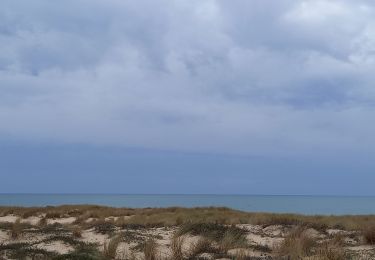
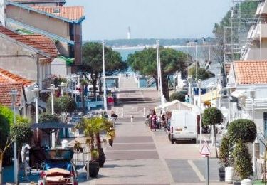
Trail Walking of 20 km to be discovered at New Aquitaine, Gironde, Lège-Cap-Ferret. This trail is proposed by YV24.
Description
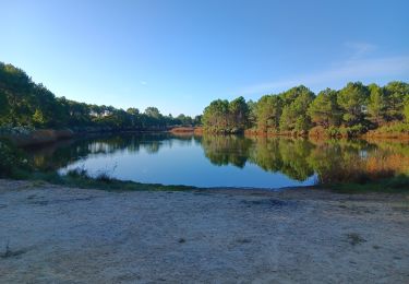
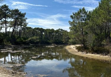
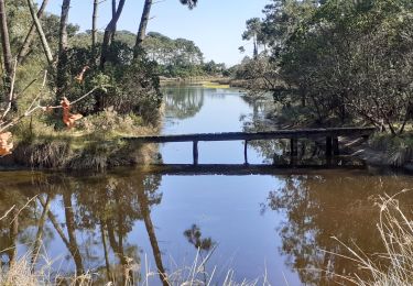
Au départ du VVF de Claouey. Tracé varié combinant le sentier du littoral et d'autres chemins dont la réserve des près salés d'Arès. Parcours agréable, allées sous les pins, sentiers sablonneux, roselières, arbousiers, près salés...
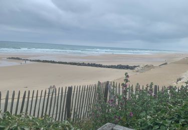
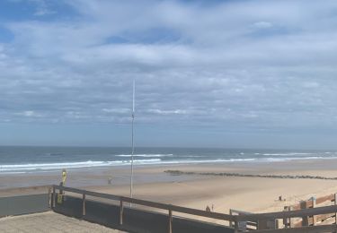
Praticable en tout temps. pour un parcours en sens inverse de la montre, préférez un départ à marée basse, les vues sur le bassin d'Arcachon sont plus sympas. Pique nique possible aux cabanes à huîtres du port d'Arès.
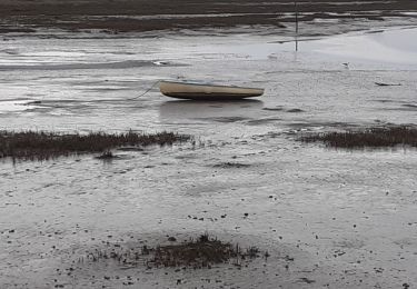
ATTENTION ; en octobre 2019 la passerelle sur le courant de lège est condamnée, ce qui oblige à remonter au giratoire de la D106.
Positioning
Comments
Trails nearby
![Trail Hybrid bike Arès - Vélo Arès Cap Feret - Photo](https://media.geolcdn.com/t/375/260/873f7bb6-c81f-4ee5-ac74-bed0238ffe60.jpg&format=jpg&maxdim=2)
![Hybrid bike Hybrid bike](https://static1.geolcdn.com/sitytour/trail-icons/203.png)
Hybrid bike
![](/images/other/stat-length.png)
![](https://static1.geolcdn.com/siteimages/upload/files/16400158638029165_repeat_loop_refresh_sync_direction_icon.png)
![Trail Electric bike Lège-Cap-Ferret - Sortie Lacanau - Photo](https://media.geolcdn.com/t/375/260/7ed4c728-c115-445a-a435-85386e44651b.jpg&format=jpg&maxdim=2)
![Electric bike Electric bike](https://static1.geolcdn.com/sitytour/trail-icons/205.png)
Electric bike
![](/images/other/stat-length.png)
![](https://static1.geolcdn.com/siteimages/upload/files/16400158638029165_repeat_loop_refresh_sync_direction_icon.png)
![Trail Electric bike Lège-Cap-Ferret - Le cap feret - Photo](https://media.geolcdn.com/t/375/260/8217cc80-b40e-44d9-800c-e425422724f5.jpg&format=jpg&maxdim=2)
![Electric bike Electric bike](https://static1.geolcdn.com/sitytour/trail-icons/205.png)
Electric bike
![](/images/other/stat-length.png)
![](https://static1.geolcdn.com/siteimages/upload/files/16400158638029165_repeat_loop_refresh_sync_direction_icon.png)
![Trail Walking Arès - les prés salés la teste de buch - Photo](https://media.geolcdn.com/t/375/260/fc01b79f-f710-46c8-99b3-a8ce921b7899.jpg&format=jpg&maxdim=2)
![Walking Walking](https://static1.geolcdn.com/sitytour/trail-icons/101.png)
Walking
![](/images/other/stat-length.png)
![](https://static1.geolcdn.com/siteimages/upload/files/16400158638029165_repeat_loop_refresh_sync_direction_icon.png)
![Trail Cycle Arès - de Ares à Sanguinet - Photo](https://media.geolcdn.com/t/375/260/ext.jpg?maxdim=2&url=https%3A%2F%2Fservices.sitytrail.com%2FGeolivesWS%2FDownloadMedia.ashx%3FTrailID%3D450845%26Media%3D2cca1fec-375e-4780-a004-31cdd349b60d.jpg)
![Cycle Cycle](https://static1.geolcdn.com/sitytour/trail-icons/200.png)
![Trail Running Lège-Cap-Ferret - Solocéan - Photo](https://media.geolcdn.com/t/375/260/64b33a6a-464a-4678-b2a1-70c6bfa068e8.jpg&format=jpg&maxdim=2)
![Running Running](https://static1.geolcdn.com/sitytour/trail-icons/103.png)
![Trail Walking Arès - port ostréicole Ares-Lège - Photo](https://media.geolcdn.com/t/375/260/2a1536ba-8455-407e-9501-1bda7f7191de.jpg&format=jpg&maxdim=2)
![Walking Walking](https://static1.geolcdn.com/sitytour/trail-icons/101.png)
Walking
![](/images/other/stat-length.png)
![](https://static1.geolcdn.com/siteimages/upload/files/16400158638029165_repeat_loop_refresh_sync_direction_icon.png)
![Trail sport Lège-Cap-Ferret - Réserve naturelle de piraillan - Photo](https://media.geolcdn.com/t/375/260/96eaf589-c926-4bc3-bb46-100f4c4101f7.jpg&format=jpg&maxdim=2)
sport
![](/images/other/stat-length.png)
![](https://static1.geolcdn.com/siteimages/upload/files/16400158638029165_repeat_loop_refresh_sync_direction_icon.png)
![Trail Walking Lège-Cap-Ferret - les réservoirs de Piraillan - Photo](https://media.geolcdn.com/t/375/260/7e68497c-ed53-46d0-afd3-a288ec020b2c.jpg&format=jpg&maxdim=2)
![Walking Walking](https://static1.geolcdn.com/sitytour/trail-icons/101.png)
Walking
![](/images/other/stat-length.png)
![](https://static1.geolcdn.com/siteimages/upload/files/16400158638029165_repeat_loop_refresh_sync_direction_icon.png)