![](/images/other/stat-length.png)
![Trail Walking Belvézet - Belvezet et mas de l'ancienne église - Photo](https://media.geolcdn.com/t/1900/400/ext.pjpeg?maxdim=2&url=https%3A%2F%2Fstatic1.geolcdn.com%2Fsiteimages%2Fupload%2Ffiles%2F1553511878bg_sport_marche.png)
Belvezet et mas de l'ancienne église
randotines
User GUIDE
![Length](/images/other/stat-length.png)
Length
13.6 km
![Max alt](https://static1.geolcdn.com/siteimages/upload/files/1508320355ic_sort_altitude_max_24dp.png)
Max alt
271 m
![Uphill gradient](https://static1.geolcdn.com/siteimages/upload/files/1508320355ic_sort_den_pos_24dp.png)
Uphill gradient
282 m
![Km-Effort](/images/other/stat-length.png)
Km-Effort
17.4 km
![Min alt](https://static1.geolcdn.com/siteimages/upload/files/1508320355ic_sort_altitude_min_24dp.png)
Min alt
128 m
![Downhill gradient](https://static1.geolcdn.com/siteimages/upload/files/1508320355ic_sort_den_neg_24dp.png)
Downhill gradient
280 m
![Boucle](https://static1.geolcdn.com/siteimages/upload/files/16400158638029165_repeat_loop_refresh_sync_direction_icon.png)
Boucle
Yes
Creation date :
2014-12-10 00:00:00.0
Updated on :
2014-12-10 00:00:00.0
![Walking](https://static1.geolcdn.com/sitytour/trail-icons/101.png)
3h45
Difficulty : Medium
![Scan this QR Code to open this trail in the SityTrail application](https://capi.geolives.com/qq0zvz2zws4bq2lad0pu/sitytour/trails/222696/qr.png?size=200)
FREE GPS app for hiking
About
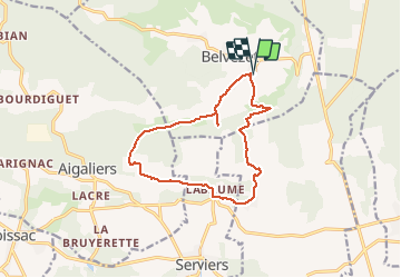
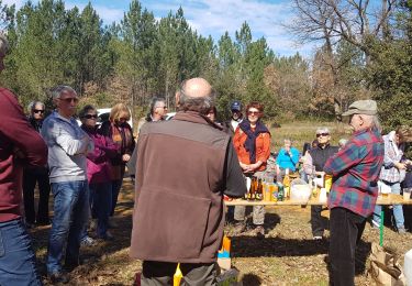
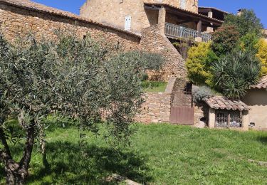
Trail Walking of 13.6 km to be discovered at Occitania, Gard, Belvézet. This trail is proposed by randotines.
Description
Situation : 15 km au nord d'Uzès par les D979 et D 218.
Balade à programmer en arrière saison.Emprunte des sentiers jadis fréquentés par les troupes de camisards.
Positioning
Country:
France
Region :
Occitania
Department/Province :
Gard
Municipality :
Belvézet
Location:
Unknown
Start:(Dec)
Start:(UTM)
609901 ; 4881656 (31T) N.
Comments
Trails nearby
![Trail Walking Serviers-et-Labaume - servers labame 2012 - Photo](https://media.geolcdn.com/t/375/260/ext.jpg?maxdim=2&url=https%3A%2F%2Fstatic1.geolcdn.com%2Fsiteimages%2Fupload%2Ffiles%2F1553511878bg_sport_marche.png)
![Walking Walking](https://static1.geolcdn.com/sitytour/trail-icons/101.png)
servers labame 2012
Walking
Medium
(2)
Serviers-et-Labaume,
Occitania,
Gard,
France
![](/images/other/stat-length.png)
13.8 km | 16.7 km-effort
1h 55min
![](https://static1.geolcdn.com/siteimages/upload/files/16400158638029165_repeat_loop_refresh_sync_direction_icon.png)
Yes
![Trail Walking Belvézet - Autour du Mas de l'ancienne église - Photo](https://media.geolcdn.com/t/375/260/09c6bc09-8ddc-4e77-b2f3-b76dc4d1de9e.jpg&format=jpg&maxdim=2)
![Walking Walking](https://static1.geolcdn.com/sitytour/trail-icons/101.png)
Autour du Mas de l'ancienne église
Walking
Medium
Belvézet,
Occitania,
Gard,
France
![](/images/other/stat-length.png)
19.2 km | 25 km-effort
5h 28min
![](https://static1.geolcdn.com/siteimages/upload/files/16400158638029165_repeat_loop_refresh_sync_direction_icon.png)
Yes
![Trail Walking Belvézet - Belvédère - Photo](https://media.geolcdn.com/t/375/260/27d01b8c-cd56-47f4-8b45-e0d7b0e0b71a.jpg&format=jpg&maxdim=2)
![Walking Walking](https://static1.geolcdn.com/sitytour/trail-icons/101.png)
Belvédère
Walking
Very difficult
Belvézet,
Occitania,
Gard,
France
![](/images/other/stat-length.png)
19.2 km | 25 km-effort
6h 14min
![](https://static1.geolcdn.com/siteimages/upload/files/16400158638029165_repeat_loop_refresh_sync_direction_icon.png)
Yes
![Trail Walking Serviers-et-Labaume - servers labame 2012 - Photo](https://media.geolcdn.com/t/375/260/ext.jpg?maxdim=2&url=https%3A%2F%2Fstatic1.geolcdn.com%2Fsiteimages%2Fupload%2Ffiles%2F1553511878bg_sport_marche.png)
![Walking Walking](https://static1.geolcdn.com/sitytour/trail-icons/101.png)
servers labame 2012
Walking
Medium
(2)
Serviers-et-Labaume,
Occitania,
Gard,
France
![](/images/other/stat-length.png)
7 km | 8.5 km-effort
1h 56min
![](https://static1.geolcdn.com/siteimages/upload/files/16400158638029165_repeat_loop_refresh_sync_direction_icon.png)
Yes
![Trail On foot Belvézet - MONTEILLET - Photo](https://media.geolcdn.com/t/375/260/4971cba2-da85-4a64-99de-1689819e6ab4.jpeg&format=jpg&maxdim=2)
![On foot On foot](https://static1.geolcdn.com/sitytour/trail-icons/100.png)
![Trail Walking Serviers-et-Labaume - serviers - Photo](https://media.geolcdn.com/t/375/260/72c8dcb8-6a81-45f9-bdef-aca980ac6cd7.jpg&format=jpg&maxdim=2)
![Walking Walking](https://static1.geolcdn.com/sitytour/trail-icons/101.png)
serviers
Walking
Very easy
Serviers-et-Labaume,
Occitania,
Gard,
France
![](/images/other/stat-length.png)
12.5 km | 15.2 km-effort
5h 57min
![](https://static1.geolcdn.com/siteimages/upload/files/16400158638029165_repeat_loop_refresh_sync_direction_icon.png)
Yes
![Trail Other activity Aigaliers - aigaliers - Photo](https://media.geolcdn.com/t/375/260/ext.jpg?maxdim=2&url=https%3A%2F%2Fstatic1.geolcdn.com%2Fsiteimages%2Fupload%2Ffiles%2F1545311037marcheuse_200dpi.jpg)
![Other activity Other activity](https://static1.geolcdn.com/sitytour/trail-icons/900.png)
aigaliers
Other activity
Very easy
(1)
Aigaliers,
Occitania,
Gard,
France
![](/images/other/stat-length.png)
6.7 km | 8.7 km-effort
1h 44min
![](https://static1.geolcdn.com/siteimages/upload/files/16400158638029165_repeat_loop_refresh_sync_direction_icon.png)
Yes
![Trail Walking Serviers-et-Labaume - Randonnée en forêt de Massargues et vallée du Bourdic - Serviers et Labaume - Photo](https://media.geolcdn.com/t/375/260/ext.jpg?maxdim=2&url=https%3A%2F%2Fservices.sitytrail.com%2FGeolivesWS%2FDownloadMedia.ashx%3FTrailID%3D191336%26Media%3D14893_6.jpg)
![Walking Walking](https://static1.geolcdn.com/sitytour/trail-icons/101.png)
Randonnée en forêt de Massargues et vallée du Bourdic - Serviers et Labaume
Walking
Medium
Serviers-et-Labaume,
Occitania,
Gard,
France
![](/images/other/stat-length.png)
16.3 km | 19.9 km-effort
4h 30min
![](https://static1.geolcdn.com/siteimages/upload/files/16400158638029165_repeat_loop_refresh_sync_direction_icon.png)
Yes
![Trail Walking Montaren-et-Saint-Médiers - 2024-04-02 - Photo](https://media.geolcdn.com/t/375/260/a47edac5-aaa6-4892-8cba-5d84f0a0d52b.jpg&format=jpg&maxdim=2)
![Walking Walking](https://static1.geolcdn.com/sitytour/trail-icons/101.png)
2024-04-02
Walking
Medium
Montaren-et-Saint-Médiers,
Occitania,
Gard,
France
![](/images/other/stat-length.png)
7.4 km | 9.5 km-effort
2h 45min
![](https://static1.geolcdn.com/siteimages/upload/files/16400158638029165_repeat_loop_refresh_sync_direction_icon.png)
Yes