


Usa_day2_LA_Laughlin

DenisBeranger
User
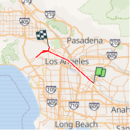

Length
45 km

Max alt
197 m

Uphill gradient
578 m
Km-Effort
52 km

Min alt
34 m

Downhill gradient
435 m
Boucle
No
Creation date :
2019-10-10 15:28:00.0
Updated on :
2019-10-10 19:34:37.605
1h23
Difficulty : Unknown

FREE GPS app for hiking
 SityTrail
IGN / Geographical institutes
SityTrail World
The world is yours!
About
Trail Car of 45 km to be discovered at California, Los Angeles County, Unknown. This trail is proposed by DenisBeranger.
Photos


Positioning
Country:
United States
Region :
California
Department/Province :
Los Angeles County
Municipality :
Unknown
Location:
Pico Rivera
Start:(Dec)
Start:(UTM)
398556 ; 3757441 (11S) N.
Comments
Trails nearby