Trail Walking Etsaut - Boucle Lescun 4J - E2 - Photo
 veneon
veneon

User

© OpenStreetMap contributors
Length
Length
25 km
Max alt
Max alt
2183 m
Uphill gradient
Uphill gradient
1930 m
Km-Effort
Km-Effort  
49 km
Min alt
Min alt
647 m
Downhill gradient
Downhill gradient
1255 m
Boucle
Boucle
No
Creation date :
2014-12-10 00:00:00.0
Updated on :
2014-12-10 00:00:00.0

(1 Reviews)

Walking
Walking
10h10
Difficulty : Unknown

Scan this QR Code to open this trail in the SityTrail application

FREE GPS app for hiking

Logo SityTrail SityTrail

IGN / Geographical institutes

Download SityTrail from the App Store Download SityTrail from Google Play

Logo SityTrail SityTrail World

The world is yours!

Download SityTrail from the App Store Download SityTrail from Google Play Download SityTrail on Huawei AppGallery

About

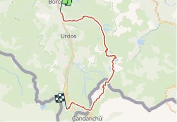
Trail Walking of 25 km to be discovered at New Aquitaine, Pyrénées-Atlantiques, Etsaut. This trail is proposed by veneon.

Description

2ème étape de la boucle de 4 jours. Passage inoubliable sur le chemin de la mature et vue superbe depuis le col d'Ayous. Par contre le passage côté espagnol n'est pas génial

Elevation profile

Positioning

Country:
France
Region :
New Aquitaine
Department/Province :
Pyrénées-Atlantiques
Municipality :
Etsaut
Location:
Unknown
Start:(UTM)
698695 ; 4752369 (30T) N.

Comments

Please log in to post a review or rate the element


Trails nearby

Trail Snowshoes Borce - Refuge et lac d’Arlet - Photo
Snowshoes
PVERTICAL

Snowshoes

Medium
(1)
Borce, New Aquitaine, Pyrénées-Atlantiques, France
16.9 km | 30 km-effort
6h 49min
Yes
Trail Walking Etsaut - CHEMIN DE LA MATURE - Photo
Walking
PVERTICAL

Walking

Medium
(2)
Etsaut, New Aquitaine, Pyrénées-Atlantiques, France
8.8 km | 18.6 km-effort
3h 25min
Yes
Trail Walking Etsaut - Chemin de la Mâture en vallée d'Aspe - Photo
Walking
tracegps

Walking

Difficult
(1)
Etsaut, New Aquitaine, Pyrénées-Atlantiques, France
7.5 km | 16.8 km-effort
4h 0min
Yes
Trail On foot Cette-Eygun - Granges de Cette asp56 - Photo
On foot
GUIDE+

On foot

Easy
Cette-Eygun, New Aquitaine, Pyrénées-Atlantiques, France
5.4 km | 10.2 km-effort
2h 18min
Yes
Trail On foot Cette-Eygun - Cabane de Lhèze asp116 - Photo
On foot
GUIDE+

On foot

Easy
Cette-Eygun, New Aquitaine, Pyrénées-Atlantiques, France
3.6 km | 9.7 km-effort
2h 11min
No
Trail On foot Cette-Eygun - Cabanes de Narbèze asp117 - Photo
On foot
GUIDE+

On foot

Easy
Cette-Eygun, New Aquitaine, Pyrénées-Atlantiques, France
6.5 km | 16.6 km-effort
3h 45min
No
Trail On foot Urdos - Tour Urdos - Bérat asp66 - Photo
On foot
GUIDE+

On foot

Easy
Urdos, New Aquitaine, Pyrénées-Atlantiques, France
4.4 km | 6.8 km-effort
1h 32min
Yes
Trail On foot Cette-Eygun - Tour de Lasies asp115 - Photo
On foot
GUIDE+

On foot

Easy
Cette-Eygun, New Aquitaine, Pyrénées-Atlantiques, France
4.3 km | 8.7 km-effort
1h 59min
No
Trail On foot Etsaut - Chemin de Beloute asp118 - Photo
On foot
GUIDE+

On foot

Easy
Etsaut, New Aquitaine, Pyrénées-Atlantiques, France
3.1 km | 8.3 km-effort
1h 53min
No


Close
My subscriptions