![](/images/other/stat-length.png)
![Trail Walking Zonza - Trou de la bombe et Punta Velacu - Photo](https://media.geolcdn.com/t/1900/400/d5bb3da4-e374-49ec-b561-b8a65b36615c.jpg&format=pjpeg&maxdim=2)
Trou de la bombe et Punta Velacu
cathymac20
User
![Length](/images/other/stat-length.png)
![Max alt](https://static1.geolcdn.com/siteimages/upload/files/1508320355ic_sort_altitude_max_24dp.png)
![Uphill gradient](https://static1.geolcdn.com/siteimages/upload/files/1508320355ic_sort_den_pos_24dp.png)
![Km-Effort](/images/other/stat-length.png)
![Min alt](https://static1.geolcdn.com/siteimages/upload/files/1508320355ic_sort_altitude_min_24dp.png)
![Downhill gradient](https://static1.geolcdn.com/siteimages/upload/files/1508320355ic_sort_den_neg_24dp.png)
![Boucle](https://static1.geolcdn.com/siteimages/upload/files/16400158638029165_repeat_loop_refresh_sync_direction_icon.png)
![Walking](https://static1.geolcdn.com/sitytour/trail-icons/101.png)
4h43
Difficulty : Easy
![Scan this QR Code to open this trail in the SityTrail application](https://capi.geolives.com/qq0zvz2zws4bq2lad0pu/sitytour/trails/2225032/qr.png?size=200)
FREE GPS app for hiking
About
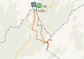
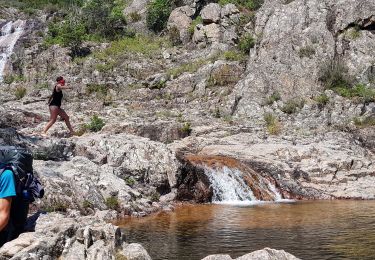
Trail Walking of 9.4 km to be discovered at Corsica, South Corsica, Zonza. This trail is proposed by cathymac20.
Description
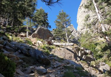
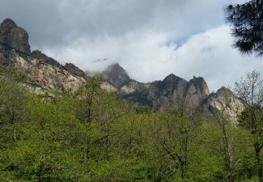
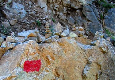
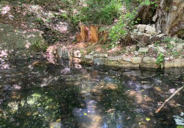
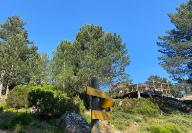
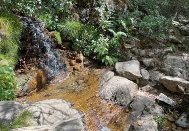
Départ du parking de la vierge, plusieurs chemin sont possibles pour le trou de la bombe....l embranchement pour la punta Velaco n'est pas très loin mais mal indiqué, si vous avez un gps c est mieux le chemin est marqué, juste pour l embranchement car après le chemin est bien cairné, même si parfois si ils sont difficilement repérables parmi les nombreuses pierres. Sur la fin il faut s aider de ses mains, mais rien de bien difficile. en haut un panorama vraiment merveilleux à 360°
Positioning
Comments
Trails nearby
![Trail Walking Quenza - tour de bavella - Photo](https://media.geolcdn.com/t/375/260/91546040-d47b-499f-8f25-3061dbb3b1e0.jpg&format=jpg&maxdim=2)
![Walking Walking](https://static1.geolcdn.com/sitytour/trail-icons/101.png)
Walking
![](/images/other/stat-length.png)
![](https://static1.geolcdn.com/siteimages/upload/files/16400158638029165_repeat_loop_refresh_sync_direction_icon.png)
![Trail Walking Zonza - Boucle du trou de la bombe - Bavella - Photo](https://media.geolcdn.com/t/375/260/57ec4c61-a922-4825-a53b-adb705edbd02.jpg&format=jpg&maxdim=2)
![Walking Walking](https://static1.geolcdn.com/sitytour/trail-icons/101.png)
Walking
![](/images/other/stat-length.png)
![](https://static1.geolcdn.com/siteimages/upload/files/16400158638029165_repeat_loop_refresh_sync_direction_icon.png)
![Trail Walking Quenza - chemin corse - Photo](https://media.geolcdn.com/t/375/260/ext.jpg?maxdim=2&url=https%3A%2F%2Fservices.sitytrail.com%2FGeolivesWS%2FDownloadMedia.ashx%3FTrailID%3D743798%26Media%3Dfix__20170501115404.jpg)
![Walking Walking](https://static1.geolcdn.com/sitytour/trail-icons/101.png)
Walking
![](/images/other/stat-length.png)
![](https://static1.geolcdn.com/siteimages/upload/files/16400158638029165_repeat_loop_refresh_sync_direction_icon.png)
![Trail Walking Zonza - Bavella_trou de la bombe - Photo](https://media.geolcdn.com/t/375/260/ext.jpg?maxdim=2&url=https%3A%2F%2Fservices.sitytrail.com%2FGeolivesWS%2FDownloadMedia.ashx%3FTrailID%3D198331%26Media%3D1886eeb5-9e06-40d9-ad21-e8df8d175266.jpg)
![Walking Walking](https://static1.geolcdn.com/sitytour/trail-icons/101.png)
Walking
![](/images/other/stat-length.png)
![](https://static1.geolcdn.com/siteimages/upload/files/16400158638029165_repeat_loop_refresh_sync_direction_icon.png)
![Trail Walking Quenza - Les aiguilles de Bavella - Photo](https://media.geolcdn.com/t/375/260/ext.jpg?maxdim=2&url=https%3A%2F%2Fstatic1.geolcdn.com%2Fsiteimages%2Fupload%2Ffiles%2F1553511878bg_sport_marche.png)
![Walking Walking](https://static1.geolcdn.com/sitytour/trail-icons/101.png)
Walking
![](/images/other/stat-length.png)
![](https://static1.geolcdn.com/siteimages/upload/files/16400158638029165_repeat_loop_refresh_sync_direction_icon.png)
![Trail Walking Conca - Paliri Conca - Photo](https://media.geolcdn.com/t/375/260/8129a798-c8a0-4a1d-9b4b-9f49d3407a5a.jpg&format=jpg&maxdim=2)
![Walking Walking](https://static1.geolcdn.com/sitytour/trail-icons/101.png)
Walking
![](/images/other/stat-length.png)
![](https://static1.geolcdn.com/siteimages/upload/files/16400158638029165_repeat_loop_refresh_sync_direction_icon.png)
![Trail Walking Quenza - Refuge Aline Paliri - Photo](https://media.geolcdn.com/t/375/260/64e98614-54d0-47ee-aa13-b132cf042059.jpg&format=jpg&maxdim=2)
![Walking Walking](https://static1.geolcdn.com/sitytour/trail-icons/101.png)
Walking
![](/images/other/stat-length.png)
![](https://static1.geolcdn.com/siteimages/upload/files/16400158638029165_repeat_loop_refresh_sync_direction_icon.png)
![Trail Walking Conca - eta 2 - Photo](https://media.geolcdn.com/t/375/260/2e5824f5-cee9-4ee9-b75e-599680df0276.jpg&format=jpg&maxdim=2)
![Walking Walking](https://static1.geolcdn.com/sitytour/trail-icons/101.png)
![Trail Walking Conca - Corse - GR20 Paliri à Conca - Photo](https://media.geolcdn.com/t/375/260/374a964b-6d4e-4e78-8a0e-bd563fc5fe7d.jpg&format=jpg&maxdim=2)
![Walking Walking](https://static1.geolcdn.com/sitytour/trail-icons/101.png)
Walking
![](/images/other/stat-length.png)
![](https://static1.geolcdn.com/siteimages/upload/files/16400158638029165_repeat_loop_refresh_sync_direction_icon.png)