![](/images/other/stat-length.png)
![Trail Walking Budos - Sur les chemins de Budos - Photo](https://media.geolcdn.com/t/1900/400/ext.pjpeg?maxdim=2&url=https%3A%2F%2Fstatic1.geolcdn.com%2Fsiteimages%2Fupload%2Ffiles%2F1553511878bg_sport_marche.png)
Sur les chemins de Budos
Elbe
User
![Length](/images/other/stat-length.png)
![Max alt](https://static1.geolcdn.com/siteimages/upload/files/1508320355ic_sort_altitude_max_24dp.png)
![Uphill gradient](https://static1.geolcdn.com/siteimages/upload/files/1508320355ic_sort_den_pos_24dp.png)
![Km-Effort](/images/other/stat-length.png)
![Min alt](https://static1.geolcdn.com/siteimages/upload/files/1508320355ic_sort_altitude_min_24dp.png)
![Downhill gradient](https://static1.geolcdn.com/siteimages/upload/files/1508320355ic_sort_den_neg_24dp.png)
![Boucle](https://static1.geolcdn.com/siteimages/upload/files/16400158638029165_repeat_loop_refresh_sync_direction_icon.png)
![Walking](https://static1.geolcdn.com/sitytour/trail-icons/101.png)
2h58
Difficulty : Unknown
![Scan this QR Code to open this trail in the SityTrail application](https://capi.geolives.com/qq0zvz2zws4bq2lad0pu/sitytour/trails/222479/qr.png?size=200)
FREE GPS app for hiking
About
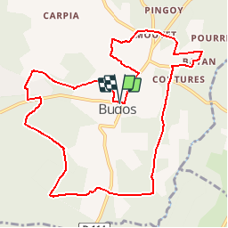
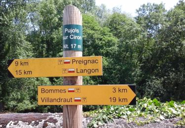
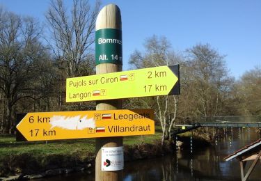
Trail Walking of 11.9 km to be discovered at New Aquitaine, Gironde, Budos. This trail is proposed by Elbe.
Description
Randonnée publiée dans "Le républicain" du 19/09/2013 par :
"Les Mille Pieds de Podensac"
Village de Budos (Gironde 33)
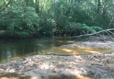
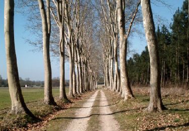
Une belle balade de 12 kms entre vignes et forêt.
Une grande partie sur les chemins.
A voir en chemin : lavoirs, moulin, pigeonnier, château et Eglise.
A faire en toute saison.
Bonne randonnée
Positioning
Comments
Trails nearby
![Trail On foot Bommes - Les Brumes d'Or : circuit départemental - Photo](https://media.geolcdn.com/t/375/260/2f15b51c-47d5-4488-8fcf-c929ae2eb90f.jpeg&format=jpg&maxdim=2)
![On foot On foot](https://static1.geolcdn.com/sitytour/trail-icons/100.png)
On foot
![](/images/other/stat-length.png)
![](https://static1.geolcdn.com/siteimages/upload/files/16400158638029165_repeat_loop_refresh_sync_direction_icon.png)
![Trail On foot Léogeats - Les Radjayres : boucle locale - Photo](https://media.geolcdn.com/t/375/260/709b87d5-dc25-4355-8e13-184e5dd28e24.jpeg&format=jpg&maxdim=2)
![On foot On foot](https://static1.geolcdn.com/sitytour/trail-icons/100.png)
On foot
![](/images/other/stat-length.png)
![](https://static1.geolcdn.com/siteimages/upload/files/16400158638029165_repeat_loop_refresh_sync_direction_icon.png)
![Trail On foot Léogeats - La Hounrède : boucle locale - Photo](https://media.geolcdn.com/t/375/260/b9f504ad-15ec-4c0d-8014-4ba7e3790a5c.jpeg&format=jpg&maxdim=2)
![On foot On foot](https://static1.geolcdn.com/sitytour/trail-icons/100.png)
On foot
![](/images/other/stat-length.png)
![](https://static1.geolcdn.com/siteimages/upload/files/16400158638029165_repeat_loop_refresh_sync_direction_icon.png)
![Trail On foot Pujols-sur-Ciron - Pujols-sur-Ciron : boucle locale - Photo](https://media.geolcdn.com/t/375/260/4bb33481-f8b6-4fa1-82f8-39d6baec9777.jpeg&format=jpg&maxdim=2)
![On foot On foot](https://static1.geolcdn.com/sitytour/trail-icons/100.png)
On foot
![](/images/other/stat-length.png)
![](https://static1.geolcdn.com/siteimages/upload/files/16400158638029165_repeat_loop_refresh_sync_direction_icon.png)
![Trail On foot Sauternes - Botrytis Cinéréa : boucle locale - Photo](https://media.geolcdn.com/t/375/260/8afb987e-33f8-4c41-afd4-69d61de108bc.jpeg&format=jpg&maxdim=2)
![On foot On foot](https://static1.geolcdn.com/sitytour/trail-icons/100.png)
On foot
![](/images/other/stat-length.png)
![](https://static1.geolcdn.com/siteimages/upload/files/16400158638029165_repeat_loop_refresh_sync_direction_icon.png)
![Trail On foot Bommes - Le Vin Soleil : boucle locale - Photo](https://media.geolcdn.com/t/375/260/b847a612-583a-4db4-bc70-59d85fb4a52f.jpeg&format=jpg&maxdim=2)
![On foot On foot](https://static1.geolcdn.com/sitytour/trail-icons/100.png)
On foot
![](/images/other/stat-length.png)
![](https://static1.geolcdn.com/siteimages/upload/files/16400158638029165_repeat_loop_refresh_sync_direction_icon.png)
![Trail Horseback riding Landiras - Val de Tursan - Haras de la Grézère - Photo](https://media.geolcdn.com/t/375/260/5a46d3e1-1e3e-4ba6-896b-99db9310a394.jpg&format=jpg&maxdim=2)
![Horseback riding Horseback riding](https://static1.geolcdn.com/sitytour/trail-icons/301.png)
Horseback riding
![](/images/other/stat-length.png)
![](https://static1.geolcdn.com/siteimages/upload/files/16400158638029165_repeat_loop_refresh_sync_direction_icon.png)
![Trail Walking Sauternes - Châteaux de Sauternes - Photo](https://media.geolcdn.com/t/375/260/2ccd1316-c7f8-4488-94d6-6ebb1c48cba5.jpg&format=jpg&maxdim=2)
![Walking Walking](https://static1.geolcdn.com/sitytour/trail-icons/101.png)
Walking
![](/images/other/stat-length.png)
![](https://static1.geolcdn.com/siteimages/upload/files/16400158638029165_repeat_loop_refresh_sync_direction_icon.png)
![Trail Mountain bike Sauternes - Autour de Sauternes - Photo](https://media.geolcdn.com/t/375/260/ext.jpg?maxdim=2&url=https%3A%2F%2Fservices.sitytrail.com%2FGeolivesWS%2FDownloadMedia.ashx%3FTrailID%3D102792%26Media%3D3954_1.jpg)
![Mountain bike Mountain bike](https://static1.geolcdn.com/sitytour/trail-icons/202.png)
Mountain bike
![](/images/other/stat-length.png)
![](https://static1.geolcdn.com/siteimages/upload/files/16400158638029165_repeat_loop_refresh_sync_direction_icon.png)