![](/images/other/stat-length.png)
![Trail On foot Dinant - Promenade de Notre Dame de Foy - Photo](https://media.geolcdn.com/t/1900/400/ext.pjpeg?maxdim=2&url=https%3A%2F%2Fstatic1.geolcdn.com%2Fsiteimages%2Fupload%2Ffiles%2F1545311037marcheuse_200dpi.jpg)
Promenade de Notre Dame de Foy
ValleedelaMeuse
User
![Length](/images/other/stat-length.png)
Length
7.8 km
![Max alt](https://static1.geolcdn.com/siteimages/upload/files/1508320355ic_sort_altitude_max_24dp.png)
Max alt
293 m
![Uphill gradient](https://static1.geolcdn.com/siteimages/upload/files/1508320355ic_sort_den_pos_24dp.png)
Uphill gradient
159 m
![Km-Effort](/images/other/stat-length.png)
Km-Effort
9.9 km
![Min alt](https://static1.geolcdn.com/siteimages/upload/files/1508320355ic_sort_altitude_min_24dp.png)
Min alt
186 m
![Downhill gradient](https://static1.geolcdn.com/siteimages/upload/files/1508320355ic_sort_den_neg_24dp.png)
Downhill gradient
162 m
![Boucle](https://static1.geolcdn.com/siteimages/upload/files/16400158638029165_repeat_loop_refresh_sync_direction_icon.png)
Boucle
Yes
Creation date :
2019-10-07 08:42:50.48
Updated on :
2019-10-07 08:51:05.992
![On foot](https://static1.geolcdn.com/sitytour/trail-icons/100.png)
2h40
Difficulty : Very easy
![Scan this QR Code to open this trail in the SityTrail application](https://capi.geolives.com/qq0zvz2zws4bq2lad0pu/sitytour/trails/2223938/qr.png?size=200)
FREE GPS app for hiking
About
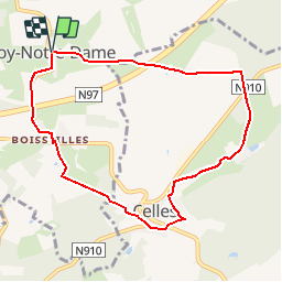
Trail On foot of 7.8 km to be discovered at Wallonia, Namur, Dinant. This trail is proposed by ValleedelaMeuse.
Description
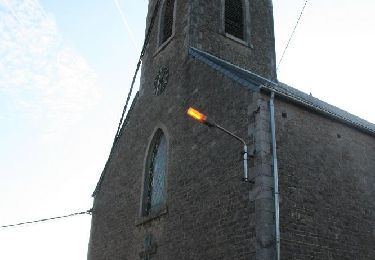
Départ de l' église de Foy.Direction Celles en passant par la ferme d'Hubaille. Vous remontez sur Boisseille .Il vous reste 1,5 KM pour arriver à votre point de départ.
Positioning
Country:
Belgium
Region :
Wallonia
Department/Province :
Namur
Municipality :
Dinant
Location:
Foy-Notre-Dame
Start:(Dec)
Start:(UTM)
641873 ; 5567996 (31U) N.
Comments
Trails nearby
![Trail Walking Houyet - Nature - The Payenne trail (Houyet) - Photo](https://media.geolcdn.com/t/375/260/ext.jpg?maxdim=2&url=https%3A%2F%2Fservices.sitytrail.com%2FGeolivesWS%2FDownloadMedia.ashx%3FTrailID%3D247221%26Media%3D4a1116e4-3cc3-4f81-a279-87cb261b0cef.jpg)
![Walking Walking](https://static1.geolcdn.com/sitytour/trail-icons/101.png)
Nature - The Payenne trail (Houyet)
Walking
Difficult
(5)
Houyet,
Wallonia,
Namur,
Belgium
![](/images/other/stat-length.png)
14.3 km | 19 km-effort
4h 18min
![](https://static1.geolcdn.com/siteimages/upload/files/16400158638029165_repeat_loop_refresh_sync_direction_icon.png)
Yes
![Trail Walking Houyet - La Lesse, Natura 2000 - Des sites qui valent le détour, Na07 - Photo](https://media.geolcdn.com/t/375/260/ext.jpg?maxdim=2&url=https%3A%2F%2Fservices.sitytrail.com%2FGeolivesWS%2FDownloadMedia.ashx%3FTrailID%3D188163%26Media%3Df0b29f0e-e19a-4fa8-a869-5ab27b1769d7.JPG)
![Walking Walking](https://static1.geolcdn.com/sitytour/trail-icons/101.png)
La Lesse, Natura 2000 - Des sites qui valent le détour, Na07
Walking
Difficult
(9)
Houyet,
Wallonia,
Namur,
Belgium
![](/images/other/stat-length.png)
8.8 km | 11.5 km-effort
2h 33min
![](https://static1.geolcdn.com/siteimages/upload/files/16400158638029165_repeat_loop_refresh_sync_direction_icon.png)
Yes
![Trail Walking Houyet - RB-Na-05 Hauts lieux de la basse Lesse - Photo](https://media.geolcdn.com/t/375/260/ext.jpg?maxdim=2&url=https%3A%2F%2Fservices.sitytrail.com%2FGeolivesWS%2FDownloadMedia.ashx%3FTrailID%3D179631%26Media%3D95d7547e-2b07-4681-8a2a-4a37901ae9c7.jpg)
![Walking Walking](https://static1.geolcdn.com/sitytour/trail-icons/101.png)
RB-Na-05 Hauts lieux de la basse Lesse
Walking
Medium
(9)
Houyet,
Wallonia,
Namur,
Belgium
![](/images/other/stat-length.png)
24 km | 31 km-effort
6h 33min
![](https://static1.geolcdn.com/siteimages/upload/files/16400158638029165_repeat_loop_refresh_sync_direction_icon.png)
Yes
![Trail Walking Houyet - RB-Na-05 Raccourci 1 - Hauts lieux de la basse Lesse - Photo](https://media.geolcdn.com/t/375/260/ext.jpg?maxdim=2&url=https%3A%2F%2Fservices.sitytrail.com%2FGeolivesWS%2FDownloadMedia.ashx%3FTrailID%3D213753%26Media%3D8bab1d47-4651-4050-8b88-78bf90d52eb5.jpg)
![Walking Walking](https://static1.geolcdn.com/sitytour/trail-icons/101.png)
RB-Na-05 Raccourci 1 - Hauts lieux de la basse Lesse
Walking
Easy
(5)
Houyet,
Wallonia,
Namur,
Belgium
![](/images/other/stat-length.png)
21 km | 26 km-effort
5h 37min
![](https://static1.geolcdn.com/siteimages/upload/files/16400158638029165_repeat_loop_refresh_sync_direction_icon.png)
Yes
![Trail Walking Houyet - Nature & heritage in Celles, one of the Most Beautiful Villages of Wallonia - Photo](https://media.geolcdn.com/t/375/260/ac9d387c-3f8d-401d-bffe-044b71ce3eff.jpg&format=jpg&maxdim=2)
![Walking Walking](https://static1.geolcdn.com/sitytour/trail-icons/101.png)
Nature & heritage in Celles, one of the Most Beautiful Villages of Wallonia
Walking
Medium
(6)
Houyet,
Wallonia,
Namur,
Belgium
![](/images/other/stat-length.png)
9.6 km | 12.7 km-effort
2h 52min
![](https://static1.geolcdn.com/siteimages/upload/files/16400158638029165_repeat_loop_refresh_sync_direction_icon.png)
Yes
![Trail Walking Houyet - Nature and heritage - The Castle of Vêves walk - Photo](https://media.geolcdn.com/t/375/260/ext.jpg?maxdim=2&url=https%3A%2F%2Fservices.sitytrail.com%2FGeolivesWS%2FDownloadMedia.ashx%3FTrailID%3D193554%26Media%3D89a5bf6a-392e-4b4e-aa1f-d6a80dc2ba50.JPG)
![Walking Walking](https://static1.geolcdn.com/sitytour/trail-icons/101.png)
Nature and heritage - The Castle of Vêves walk
Walking
Medium
(6)
Houyet,
Wallonia,
Namur,
Belgium
![](/images/other/stat-length.png)
6.4 km | 8.7 km-effort
1h 49min
![](https://static1.geolcdn.com/siteimages/upload/files/16400158638029165_repeat_loop_refresh_sync_direction_icon.png)
Yes
![Trail Walking Houyet - GG-NA-20_Gendron-Celles - Dinant - Photo](https://media.geolcdn.com/t/375/260/ab939ff5-5b33-43fd-b036-e462abc33a68.jpg&format=jpg&maxdim=2)
![Walking Walking](https://static1.geolcdn.com/sitytour/trail-icons/101.png)
GG-NA-20_Gendron-Celles - Dinant
Walking
Very difficult
(6)
Houyet,
Wallonia,
Namur,
Belgium
![](/images/other/stat-length.png)
23 km | 30 km-effort
6h 27min
![](https://static1.geolcdn.com/siteimages/upload/files/16400158638029165_repeat_loop_refresh_sync_direction_icon.png)
No
![Trail Walking Houyet - Gendron trail - Lesse Valley Roadbook - Photo](https://media.geolcdn.com/t/375/260/ext.jpg?maxdim=2&url=https%3A%2F%2Fservices.sitytrail.com%2FGeolivesWS%2FDownloadMedia.ashx%3FTrailID%3D226540%26Media%3Dafe2f8cc-1965-4dae-ad91-9ef1526a8fd1.jpg)
![Walking Walking](https://static1.geolcdn.com/sitytour/trail-icons/101.png)
Gendron trail - Lesse Valley Roadbook
Walking
Medium
(4)
Houyet,
Wallonia,
Namur,
Belgium
![](/images/other/stat-length.png)
7.1 km | 9.2 km-effort
1h 58min
![](https://static1.geolcdn.com/siteimages/upload/files/16400158638029165_repeat_loop_refresh_sync_direction_icon.png)
Yes
![Trail Walking Dinant - Dinant: autour de la Citadelle. - Photo](https://media.geolcdn.com/t/375/260/0debd692-1141-41b3-8018-db8fdb788a39.jpg&format=jpg&maxdim=2)
![Walking Walking](https://static1.geolcdn.com/sitytour/trail-icons/101.png)
Dinant: autour de la Citadelle.
Walking
Easy
(4)
Dinant,
Wallonia,
Namur,
Belgium
![](/images/other/stat-length.png)
5.7 km | 7.5 km-effort
1h 40min
![](https://static1.geolcdn.com/siteimages/upload/files/16400158638029165_repeat_loop_refresh_sync_direction_icon.png)
Yes