![](/images/other/stat-length.png)
![Trail Walking La Javie - Digne : Facibelle - Photo](https://media.geolcdn.com/t/1900/400/ext.pjpeg?maxdim=2&url=https%3A%2F%2Fmedia.geolcdn.com%2Ff%2F9b91bcdd-025e-45ae-b3f1-d2ccf8355383.jpg)
Digne : Facibelle
phidge
User
![Length](/images/other/stat-length.png)
Length
7.5 km
![Max alt](https://static1.geolcdn.com/siteimages/upload/files/1508320355ic_sort_altitude_max_24dp.png)
Max alt
1230 m
![Uphill gradient](https://static1.geolcdn.com/siteimages/upload/files/1508320355ic_sort_den_pos_24dp.png)
Uphill gradient
473 m
![Km-Effort](/images/other/stat-length.png)
Km-Effort
13.8 km
![Min alt](https://static1.geolcdn.com/siteimages/upload/files/1508320355ic_sort_altitude_min_24dp.png)
Min alt
792 m
![Downhill gradient](https://static1.geolcdn.com/siteimages/upload/files/1508320355ic_sort_den_neg_24dp.png)
Downhill gradient
474 m
![Boucle](https://static1.geolcdn.com/siteimages/upload/files/16400158638029165_repeat_loop_refresh_sync_direction_icon.png)
Boucle
Yes
Creation date :
2019-10-05 06:42:41.954
Updated on :
2019-10-09 14:03:22.449
![Walking](https://static1.geolcdn.com/sitytour/trail-icons/101.png)
5h13
Difficulty : Medium
![Scan this QR Code to open this trail in the SityTrail application](https://capi.geolives.com/qq0zvz2zws4bq2lad0pu/sitytour/trails/2222726/qr.png?size=200)
FREE GPS app for hiking
About
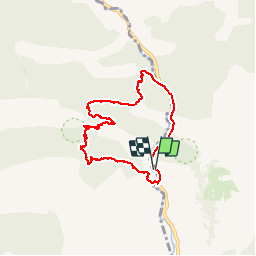
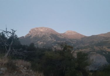
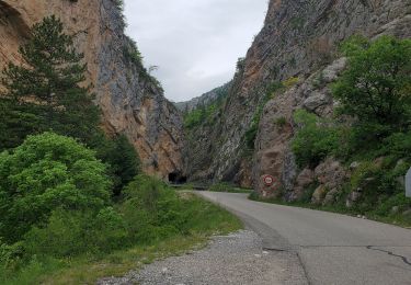
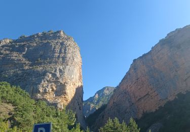
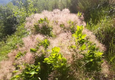
Trail Walking of 7.5 km to be discovered at Provence-Alpes-Côte d'Azur, Alpes-de-Haute-Provence, La Javie. This trail is proposed by phidge.
Description
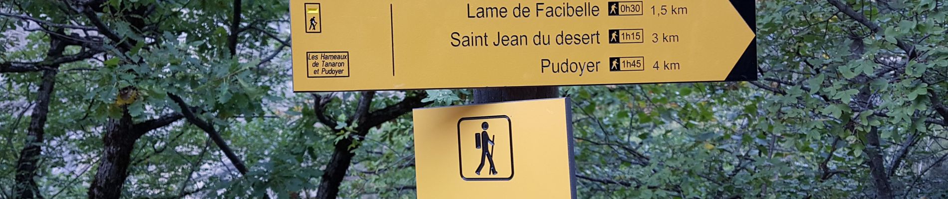
Superbe rando, passant par la "plage" avec ses coquillages fossilisés puis au pied de la lame de Facibelle, pour ensuite monter dans le Vélodrome et arriver sur le plateau St Jean ou se trouve les 2 prieurés.
Positioning
Country:
France
Region :
Provence-Alpes-Côte d'Azur
Department/Province :
Alpes-de-Haute-Provence
Municipality :
La Javie
Location:
Unknown
Start:(Dec)
Start:(UTM)
282134 ; 4898646 (32T) N.
Comments
Trails nearby
![Trail Walking La Robine-sur-Galabre - LAMBERT mourre du barri - Photo](https://media.geolcdn.com/t/375/260/ext.jpg?maxdim=2&url=https%3A%2F%2Fstatic1.geolcdn.com%2Fsiteimages%2Fupload%2Ffiles%2F1553511878bg_sport_marche.png)
![Walking Walking](https://static1.geolcdn.com/sitytour/trail-icons/101.png)
LAMBERT mourre du barri
Walking
Very easy
(1)
La Robine-sur-Galabre,
Provence-Alpes-Côte d'Azur,
Alpes-de-Haute-Provence,
France
![](/images/other/stat-length.png)
12.6 km | 21 km-effort
4h 18min
![](https://static1.geolcdn.com/siteimages/upload/files/16400158638029165_repeat_loop_refresh_sync_direction_icon.png)
Yes
![Trail Walking Barles - Grande Cloche de Barles - Photo](https://media.geolcdn.com/t/375/260/ext.jpg?maxdim=2&url=https%3A%2F%2Fstatic1.geolcdn.com%2Fsiteimages%2Fupload%2Ffiles%2F1553511878bg_sport_marche.png)
![Walking Walking](https://static1.geolcdn.com/sitytour/trail-icons/101.png)
Grande Cloche de Barles
Walking
Easy
(1)
Barles,
Provence-Alpes-Côte d'Azur,
Alpes-de-Haute-Provence,
France
![](/images/other/stat-length.png)
11.2 km | 20 km-effort
3h 58min
![](https://static1.geolcdn.com/siteimages/upload/files/16400158638029165_repeat_loop_refresh_sync_direction_icon.png)
Yes
![Trail Walking La Javie - vélodrome esclangon 17kms 1049m - Photo](https://media.geolcdn.com/t/375/260/ext.jpg?maxdim=2&url=https%3A%2F%2Fmedia.geolcdn.com%2Ff%2F41a55657-54e1-4abd-8430-e74273f3ab02.jpg)
![Walking Walking](https://static1.geolcdn.com/sitytour/trail-icons/101.png)
vélodrome esclangon 17kms 1049m
Walking
Difficult
La Javie,
Provence-Alpes-Côte d'Azur,
Alpes-de-Haute-Provence,
France
![](/images/other/stat-length.png)
15.5 km | 29 km-effort
7h 28min
![](https://static1.geolcdn.com/siteimages/upload/files/16400158638029165_repeat_loop_refresh_sync_direction_icon.png)
Yes
![Trail Walking La Robine-sur-Galabre - LA ROBINE . Les Pharaons Au fil de l eau o m s - Photo](https://media.geolcdn.com/t/375/260/ext.jpg?maxdim=2&url=https%3A%2F%2Fmedia.geolcdn.com%2Ff%2F9537e3ba-9597-438e-8aca-d930b41df6e5.jpg)
![Walking Walking](https://static1.geolcdn.com/sitytour/trail-icons/101.png)
LA ROBINE . Les Pharaons Au fil de l eau o m s
Walking
Easy
(1)
La Robine-sur-Galabre,
Provence-Alpes-Côte d'Azur,
Alpes-de-Haute-Provence,
France
![](/images/other/stat-length.png)
8.4 km | 14.3 km-effort
3h 7min
![](https://static1.geolcdn.com/siteimages/upload/files/16400158638029165_repeat_loop_refresh_sync_direction_icon.png)
Yes
![Trail Walking La Robine-sur-Galabre - AINAC Col S Antoine . Feissal o s - Photo](https://media.geolcdn.com/t/375/260/ext.jpg?maxdim=2&url=https%3A%2F%2Fmedia.geolcdn.com%2Ff%2Fa4a918fd-e34e-48ec-92ef-c8f2b718af60.jpg)
![Walking Walking](https://static1.geolcdn.com/sitytour/trail-icons/101.png)
AINAC Col S Antoine . Feissal o s
Walking
Medium
La Robine-sur-Galabre,
Provence-Alpes-Côte d'Azur,
Alpes-de-Haute-Provence,
France
![](/images/other/stat-length.png)
12.7 km | 19.3 km-effort
3h 47min
![](https://static1.geolcdn.com/siteimages/upload/files/16400158638029165_repeat_loop_refresh_sync_direction_icon.png)
Yes
![Trail Walking Barles - BARLES Le Barri AR départ le Bas Moulin o l s - Photo](https://media.geolcdn.com/t/375/260/ext.jpg?maxdim=2&url=https%3A%2F%2Fmedia.geolcdn.com%2Ff%2Fcc4a106c-cfd4-4655-a8da-47cf56370f9b.jpg)
![Walking Walking](https://static1.geolcdn.com/sitytour/trail-icons/101.png)
BARLES Le Barri AR départ le Bas Moulin o l s
Walking
Medium
Barles,
Provence-Alpes-Côte d'Azur,
Alpes-de-Haute-Provence,
France
![](/images/other/stat-length.png)
12 km | 21 km-effort
3h 49min
![](https://static1.geolcdn.com/siteimages/upload/files/16400158638029165_repeat_loop_refresh_sync_direction_icon.png)
Yes
![Trail Walking La Javie - 04 Boucle de Facibelle par chapelle St Jean - Photo](https://media.geolcdn.com/t/375/260/ext.jpg?maxdim=2&url=https%3A%2F%2Fmedia.geolcdn.com%2Ff%2F658dec62-c5c1-477c-aef9-155513deacf9.jpg)
![Walking Walking](https://static1.geolcdn.com/sitytour/trail-icons/101.png)
04 Boucle de Facibelle par chapelle St Jean
Walking
Medium
La Javie,
Provence-Alpes-Côte d'Azur,
Alpes-de-Haute-Provence,
France
![](/images/other/stat-length.png)
7.7 km | 14.5 km-effort
2h 51min
![](https://static1.geolcdn.com/siteimages/upload/files/16400158638029165_repeat_loop_refresh_sync_direction_icon.png)
Yes
![Trail Walking La Javie - Le vieil Esclangon et panorama du vélodrome - Photo](https://media.geolcdn.com/t/375/260/ext.jpg?maxdim=2&url=https%3A%2F%2Fmedia.geolcdn.com%2Ff%2F99f1d630-53d2-4365-8029-a091713c6273.jpg)
![Walking Walking](https://static1.geolcdn.com/sitytour/trail-icons/101.png)
Le vieil Esclangon et panorama du vélodrome
Walking
Easy
La Javie,
Provence-Alpes-Côte d'Azur,
Alpes-de-Haute-Provence,
France
![](/images/other/stat-length.png)
5.3 km | 9.6 km-effort
1h 42min
![](https://static1.geolcdn.com/siteimages/upload/files/16400158638029165_repeat_loop_refresh_sync_direction_icon.png)
No
![Trail Walking Le Brusquet - LE MOUSTEIRET. Ruine Chalvet .Col de l Escuichiere . Le Villard o m s - Photo](https://media.geolcdn.com/t/375/260/ext.jpg?maxdim=2&url=https%3A%2F%2Fmedia.geolcdn.com%2Ff%2F309982b8-9ac7-4ddc-b526-513e7634afc1.jpg)
![Walking Walking](https://static1.geolcdn.com/sitytour/trail-icons/101.png)
LE MOUSTEIRET. Ruine Chalvet .Col de l Escuichiere . Le Villard o m s
Walking
Medium
Le Brusquet,
Provence-Alpes-Côte d'Azur,
Alpes-de-Haute-Provence,
France
![](/images/other/stat-length.png)
10.1 km | 17.3 km-effort
3h 25min
![](https://static1.geolcdn.com/siteimages/upload/files/16400158638029165_repeat_loop_refresh_sync_direction_icon.png)
Yes