Trail Walking Sixt-Fer-à-Cheval - YHH144 Le Lignon - Brèche du Dérochoir - Photo

YHH144 Le Lignon - Brèche du Dérochoir

© OpenStreetMap contributors
Length
Length
7.4 km
Max alt
Max alt
2177 m
Uphill gradient
Uphill gradient
955 m
Km-Effort
Km-Effort  
17 km
Min alt
Min alt
1195 m
Downhill gradient
Downhill gradient
16 m
Boucle
Boucle
No
Creation date :
2015-08-24 00:00:00.0
Updated on :
2015-08-24 00:00:00.0

(0 Reviews)

Walking
Walking
3h58
Difficulty : Difficult

Scan this QR Code to open this trail in the SityTrail application

FREE GPS app for hiking

Logo SityTrail SityTrail

IGN / Geographical institutes

Download SityTrail from the App Store Download SityTrail from Google Play

Logo SityTrail SityTrail World

The world is yours!

Download SityTrail from the App Store Download SityTrail from Google Play Download SityTrail on Huawei AppGallery

About

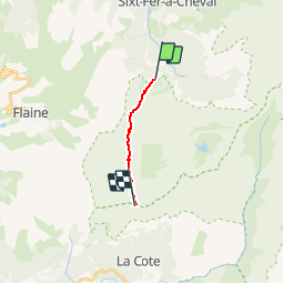
Trail Walking of 7.4 km to be discovered at Auvergne-Rhône-Alpes, Upper Savoy, Sixt-Fer-à-Cheval. This trail is proposed by yveshumbert.

Description

Rando d' une journée en boucle au Départ du parking Le Lignon.
Une première montée avec quelques cascades vous amménera jusqu' aux chalets de Sales, où vous pourrez vous restaurer. Puis le chemin est assez plat pouir un moment avant de recommencer à monter pour vous rendre à la Brèche du Dérochoir

Elevation profile

Points of interest

Point of interest Sixt-Fer-à-Cheval - Cascade de la Pleureuse - Photo
yveshumbert
SIXT-FER-À-CHEVAL 
Point of interest Sixt-Fer-à-Cheval - Cascade de la Sauffaz - Photo
yveshumbert
SIXT-FER-À-CHEVAL 
Point of interest Sixt-Fer-à-Cheval - Cascade de Sales - Photo
yveshumbert
SIXT-FER-À-CHEVAL 
Point of interest Sixt-Fer-à-Cheval - Refuge de Sales - Photo
yveshumbert
SIXT-FER-À-CHEVAL 
Point of interest Sixt-Fer-à-Cheval - Chalet de Sales - Photo
yveshumbert
SIXT-FER-À-CHEVAL 
Point of interest Sixt-Fer-à-Cheval - Le Lignon - Photo
yveshumbert
SIXT-FER-À-CHEVAL 

Positioning

Country:
France
Region :
Auvergne-Rhône-Alpes
Department/Province :
Upper Savoy
Municipality :
Sixt-Fer-à-Cheval
Location:
Unknown
Start:(UTM)
327250 ; 5098804 (32T) N.

Trails nearby

Trail Walking Sixt-Fer-à-Cheval - Lac d'Anterne - Photo
Walking
i20

Walking

Medium
(1)
Sixt-Fer-à-Cheval, Auvergne-Rhône-Alpes, Upper Savoy, France
19.8 km | 37 km-effort
5h 9min
Yes
Trail Walking Samoëns - Lac de Gers - Photo
Walking
swp648

Walking

Easy
(1)
Samoëns, Auvergne-Rhône-Alpes, Upper Savoy, France
6.7 km | 11.7 km-effort
2h 39min
No
Trail Walking Sixt-Fer-à-Cheval - Gorges des Tines - Gers - Samoens  - Photo
Walking
GUIDE
Kargil

Walking

Difficult
(1)
Sixt-Fer-à-Cheval, Auvergne-Rhône-Alpes, Upper Savoy, France
18.6 km | 33 km-effort
5h 52min
Yes
Trail Walking Sixt-Fer-à-Cheval - 2020-08-15 Marche Refuge Grenairon Le Mont Buet Les Fonts Salvagny - Photo
Walking
GUIDE
holtzv

Walking

Very easy
Sixt-Fer-à-Cheval, Auvergne-Rhône-Alpes, Upper Savoy, France
20 km | 40 km-effort
12h 24min
No
Trail Walking Sixt-Fer-à-Cheval - Le tour des Fiz : J3 - Photo
Walking
Greg813

Walking

Medium
Sixt-Fer-à-Cheval, Auvergne-Rhône-Alpes, Upper Savoy, France
10.8 km | 21 km-effort
3h 24min
No
Trail Walking Passy - Le tour des Fiz : J2 - Photo
Walking
Greg813

Walking

Difficult
Passy, Auvergne-Rhône-Alpes, Upper Savoy, France
15.7 km | 31 km-effort
4h 41min
No
Trail Walking Sixt-Fer-à-Cheval - J9GR5Nord - Photo
Walking
annehc

Walking

Very difficult
Sixt-Fer-à-Cheval, Auvergne-Rhône-Alpes, Upper Savoy, France
16.8 km | 29 km-effort
6h 36min
No
Trail Walking Sixt-Fer-à-Cheval - SIXT PASSY RESERVE: CHALETS DE SALES 2 - Photo
Walking
djeepee74

Walking

Medium
Sixt-Fer-à-Cheval, Auvergne-Rhône-Alpes, Upper Savoy, France
11.5 km | 21 km-effort
4h 50min
Yes
Trail Walking Sixt-Fer-à-Cheval - SIXT PASSY RESERVE: LE BUET MONTEE VIA GRENAIRON - RETOUR PAR LES FONDS - Photo
Walking
djeepee74

Walking

Very difficult
Sixt-Fer-à-Cheval, Auvergne-Rhône-Alpes, Upper Savoy, France
26 km | 56 km-effort
8h 42min
Yes


Close
My subscriptions