Trail Running L'Isle-Jourdain - Chardes-Moussac - Photo
© OpenStreetMap contributors
Length
Length
9.6 km
Max alt
Max alt
146 m
Uphill gradient
Uphill gradient
86 m
Km-Effort
Km-Effort  
10.8 km
Min alt
Min alt
95 m
Downhill gradient
Downhill gradient
86 m
Boucle
Boucle
Yes
Creation date :
2014-12-10 00:00:00.0
Updated on :
2014-12-10 00:00:00.0

(0 Reviews)

Running
Running
1h02
Difficulty : Easy

Scan this QR Code to open this trail in the SityTrail application

FREE GPS app for hiking

Logo SityTrail SityTrail

IGN / Geographical institutes

Download SityTrail from the App Store Download SityTrail from Google Play

Logo SityTrail SityTrail World

The world is yours!

Download SityTrail from the App Store Download SityTrail from Google Play Download SityTrail on Huawei AppGallery

About

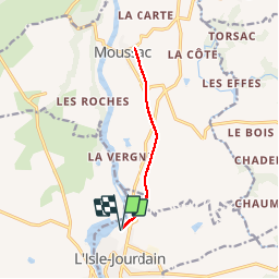
Trail Running of 9.6 km to be discovered at New Aquitaine, Vienne, L'Isle-Jourdain. This trail is proposed by motardes04.

Description

Par voie ferrée GR Pierre Folle

Elevation profile

Positioning

Country:
France
Region :
New Aquitaine
Department/Province :
Vienne
Municipality :
L'Isle-Jourdain
Location:
Unknown
Start:(UTM)
321653 ; 5123539 (31T) N.

Trails nearby

Trail Walking Moussac - moussac nerignac chantouillet - Photo
Walking
bernadette guyot

Walking

Difficult
Moussac, New Aquitaine, Vienne, France
11.5 km | 14.5 km-effort
2h 47min
Yes
Trail Mountain bike Moussac - Moussac - Photo
Mountain bike
ramsay

Mountain bike

Easy
Moussac, New Aquitaine, Vienne, France
30 km | 36 km-effort
2h 21min
Yes
Trail Mountain bike Moussac - Le Coteau des Fadets 1 - Photo
Mountain bike
ramsay

Mountain bike

Medium
(1)
Moussac, New Aquitaine, Vienne, France
34 km | 40 km-effort
2h 39min
Yes


Close
My subscriptions