![](/images/other/stat-length.png)
![Trail Walking Revel - Col du Loup - Col de la Sitre en boucle - Photo](https://media.geolcdn.com/t/1900/400/3b3fd5f2-a552-4482-81db-93310043ddd9.jpg&format=pjpeg&maxdim=2)
Col du Loup - Col de la Sitre en boucle
patjobou
User
![Length](/images/other/stat-length.png)
Length
15.8 km
![Max alt](https://static1.geolcdn.com/siteimages/upload/files/1508320355ic_sort_altitude_max_24dp.png)
Max alt
2372 m
![Uphill gradient](https://static1.geolcdn.com/siteimages/upload/files/1508320355ic_sort_den_pos_24dp.png)
Uphill gradient
1167 m
![Km-Effort](/images/other/stat-length.png)
Km-Effort
31 km
![Min alt](https://static1.geolcdn.com/siteimages/upload/files/1508320355ic_sort_altitude_min_24dp.png)
Min alt
1381 m
![Downhill gradient](https://static1.geolcdn.com/siteimages/upload/files/1508320355ic_sort_den_neg_24dp.png)
Downhill gradient
1168 m
![Boucle](https://static1.geolcdn.com/siteimages/upload/files/16400158638029165_repeat_loop_refresh_sync_direction_icon.png)
Boucle
Yes
Creation date :
2019-10-03 07:05:52.271
Updated on :
2019-10-06 17:30:37.425
![Walking](https://static1.geolcdn.com/sitytour/trail-icons/101.png)
7h26
Difficulty : Difficult
![Scan this QR Code to open this trail in the SityTrail application](https://capi.geolives.com/qq0zvz2zws4bq2lad0pu/sitytour/trails/2221056/qr.png?size=200)
FREE GPS app for hiking
About
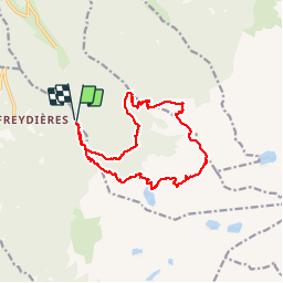
Trail Walking of 15.8 km to be discovered at Auvergne-Rhône-Alpes, Isère, Revel. This trail is proposed by patjobou.
Description
Une très belle boucle avec des paysages très variés. Belle traversée sauvage entre le col du Loup et le col de La Sitre. A faire par beau temps sec. Du col du Loup, il est possible l'aller justqu'à la Petite Lance du Crozet par la crete.
Positioning
Country:
France
Region :
Auvergne-Rhône-Alpes
Department/Province :
Isère
Municipality :
Revel
Location:
Unknown
Start:(Dec)
Start:(UTM)
728845 ; 5007813 (31T) N.
Comments
Trails nearby
![Trail On foot La Combe-de-Lancey - Chemin de Découverte (boucle Haute) - Photo](https://media.geolcdn.com/t/375/260/6a0cb0d1-93da-4068-99ad-9a549161cacf.jpeg&format=jpg&maxdim=2)
![On foot On foot](https://static1.geolcdn.com/sitytour/trail-icons/100.png)
Chemin de Découverte (boucle Haute)
On foot
Easy
La Combe-de-Lancey,
Auvergne-Rhône-Alpes,
Isère,
France
![](/images/other/stat-length.png)
3.5 km | 5.4 km-effort
1h 13min
![](https://static1.geolcdn.com/siteimages/upload/files/16400158638029165_repeat_loop_refresh_sync_direction_icon.png)
Yes
![Trail On foot Saint-Jean-le-Vieux - La Tour de Revel (par le Mollard) - Photo](https://media.geolcdn.com/t/375/260/9b2599de-7f79-405c-8210-bdfecfa7c849.jpeg&format=jpg&maxdim=2)
![On foot On foot](https://static1.geolcdn.com/sitytour/trail-icons/100.png)
La Tour de Revel (par le Mollard)
On foot
Easy
Saint-Jean-le-Vieux,
Auvergne-Rhône-Alpes,
Isère,
France
![](/images/other/stat-length.png)
7.9 km | 13.4 km-effort
3h 2min
![](https://static1.geolcdn.com/siteimages/upload/files/16400158638029165_repeat_loop_refresh_sync_direction_icon.png)
No
![Trail Snowshoes Revel - départ Raymond - Photo](https://media.geolcdn.com/t/375/260/fce30e2c-257c-480e-b905-8547371c91c2.jpg&format=jpg&maxdim=2)
![Snowshoes Snowshoes](https://static1.geolcdn.com/sitytour/trail-icons/504.png)
départ Raymond
Snowshoes
Very easy
Revel,
Auvergne-Rhône-Alpes,
Isère,
France
![](/images/other/stat-length.png)
19.9 km | 37 km-effort
7h 42min
![](https://static1.geolcdn.com/siteimages/upload/files/16400158638029165_repeat_loop_refresh_sync_direction_icon.png)
Yes
![Trail Walking Le Versoud - Le Versoud - La Poya - Croix de Revollat - Photo](https://media.geolcdn.com/t/375/260/aff89fc8-99ff-4cd9-8804-5cacdc6ef42f.jpg&format=jpg&maxdim=2)
![Walking Walking](https://static1.geolcdn.com/sitytour/trail-icons/101.png)
Le Versoud - La Poya - Croix de Revollat
Walking
Difficult
Le Versoud,
Auvergne-Rhône-Alpes,
Isère,
France
![](/images/other/stat-length.png)
18.7 km | 31 km-effort
4h 52min
![](https://static1.geolcdn.com/siteimages/upload/files/16400158638029165_repeat_loop_refresh_sync_direction_icon.png)
Yes
![Trail Walking Saint-Martin-d'Uriage - Les Seiglières. Circuit des Gardes n°9 raccourci à 8 km - Photo](https://media.geolcdn.com/t/375/260/e86aee80-f13d-4d4a-be38-285e5f19658e.jpg&format=jpg&maxdim=2)
![Walking Walking](https://static1.geolcdn.com/sitytour/trail-icons/101.png)
Les Seiglières. Circuit des Gardes n°9 raccourci à 8 km
Walking
Medium
Saint-Martin-d'Uriage,
Auvergne-Rhône-Alpes,
Isère,
France
![](/images/other/stat-length.png)
8.1 km | 12.6 km-effort
2h 51min
![](https://static1.geolcdn.com/siteimages/upload/files/16400158638029165_repeat_loop_refresh_sync_direction_icon.png)
Yes
![Trail Walking La Combe-de-Lancey - Col du Pré du Molard - Photo](https://media.geolcdn.com/t/375/260/29dc783a-080e-448f-b06b-b4c5ed8fc906.jpg&format=jpg&maxdim=2)
![Walking Walking](https://static1.geolcdn.com/sitytour/trail-icons/101.png)
Col du Pré du Molard
Walking
Difficult
La Combe-de-Lancey,
Auvergne-Rhône-Alpes,
Isère,
France
![](/images/other/stat-length.png)
17.8 km | 33 km-effort
5h 19min
![](https://static1.geolcdn.com/siteimages/upload/files/16400158638029165_repeat_loop_refresh_sync_direction_icon.png)
Yes
![Trail Walking Saint-Mury-Monteymond - Lac Blanc au pied de Belledonne - Photo](https://media.geolcdn.com/t/375/260/be8bcf54-d056-4226-93e0-f27b8cc25845.jpg&format=jpg&maxdim=2)
![Walking Walking](https://static1.geolcdn.com/sitytour/trail-icons/101.png)
Lac Blanc au pied de Belledonne
Walking
Very difficult
Saint-Mury-Monteymond,
Auvergne-Rhône-Alpes,
Isère,
France
![](/images/other/stat-length.png)
12.2 km | 26 km-effort
5h 49min
![](https://static1.geolcdn.com/siteimages/upload/files/16400158638029165_repeat_loop_refresh_sync_direction_icon.png)
Yes
![Trail Walking Revel - Montagne 15/08/2023 - Photo](https://media.geolcdn.com/t/375/260/ca509cb3-3847-45e2-a337-c41964fdee08.jpg&format=jpg&maxdim=2)
![Walking Walking](https://static1.geolcdn.com/sitytour/trail-icons/101.png)
Montagne 15/08/2023
Walking
Difficult
Revel,
Auvergne-Rhône-Alpes,
Isère,
France
![](/images/other/stat-length.png)
16.2 km | 32 km-effort
6h 36min
![](https://static1.geolcdn.com/siteimages/upload/files/16400158638029165_repeat_loop_refresh_sync_direction_icon.png)
Yes
![Trail Walking Saint-Mury-Monteymond - Col et Pointe de la Sitre - Photo](https://media.geolcdn.com/t/375/260/12aa835d-a61b-4dc5-8899-8748a81192a8.jpg&format=jpg&maxdim=2)
![Walking Walking](https://static1.geolcdn.com/sitytour/trail-icons/101.png)
Col et Pointe de la Sitre
Walking
Very difficult
Saint-Mury-Monteymond,
Auvergne-Rhône-Alpes,
Isère,
France
![](/images/other/stat-length.png)
11.2 km | 23 km-effort
5h 14min
![](https://static1.geolcdn.com/siteimages/upload/files/16400158638029165_repeat_loop_refresh_sync_direction_icon.png)
Yes