Trail Walking Châtelus - la grande cournouse - Photo
 nadd73
nadd73

User GUIDE

© OpenStreetMap contributors
Length
Length
10.5 km
Max alt
Max alt
1181 m
Uphill gradient
Uphill gradient
1160 m
Km-Effort
Km-Effort  
26 km
Min alt
Min alt
529 m
Downhill gradient
Downhill gradient
1158 m
Boucle
Boucle
Yes
Creation date :
2019-09-29 06:54:27.046
Updated on :
2019-10-01 17:50:44.652

(0 Reviews)

Walking
Walking
6h34
Difficulty : Difficult

Scan this QR Code to open this trail in the SityTrail application

FREE GPS app for hiking

Logo SityTrail SityTrail

IGN / Geographical institutes

Download SityTrail from the App Store Download SityTrail from Google Play

Logo SityTrail SityTrail World

The world is yours!

Download SityTrail from the App Store Download SityTrail from Google Play Download SityTrail on Huawei AppGallery

About

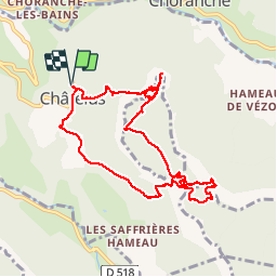
Trail Walking of 10.5 km to be discovered at Auvergne-Rhône-Alpes, Isère, Châtelus. This trail is proposed by nadd73.

Description

de Chatelus. monter à la grotte de Pabro magnifique ! et le pas de Pabro , cordes et raide attention chute de pierres. au plateau direction le pas des voûtes. mais avant d'y  aller passez  au site préhistorique très beau Sentier en limite des falaises. faire le tour et reprendre le chemin du pas des voûtes. le descendre.  
A éviter par temps humide

Elevation profile

Photos

Positioning

Country:
France
Region :
Auvergne-Rhône-Alpes
Department/Province :
Isère
Municipality :
Châtelus
Location:
Unknown
Start:(UTM)
686855 ; 4992085 (31T) N.

Trails nearby

Trail Walking Châtelus - 38 bournillon porte du diable charmatte - Photo
Walking
GUIDE
randodyssée

Walking

Difficult
(1)
Châtelus, Auvergne-Rhône-Alpes, Isère, France
16.5 km | 34 km-effort
8h 7min
Yes
Trail Walking Châtelus - Boucle Pas de l'Allier - Pas des Voutes - Photo
Walking
tracegps

Walking

Medium
(1)
Châtelus, Auvergne-Rhône-Alpes, Isère, France
10.1 km | 22 km-effort
4h 30min
Yes
Trail Walking Sainte-Eulalie-en-Royans - 26 ste eulalie - Photo
Walking
GUIDE
randodyssée

Walking

Medium
Sainte-Eulalie-en-Royans, Auvergne-Rhône-Alpes, Drôme, France
14.8 km | 27 km-effort
6h 43min
No
Trail Walking Châtelus - 38 pabro charmatte - Photo
Walking
GUIDE
randodyssée

Walking

Difficult
Châtelus, Auvergne-Rhône-Alpes, Isère, France
11.4 km | 29 km-effort
7h 43min
Yes
Trail Walking Pont-en-Royans - 38 pont en Royans choranche presles - Photo
Walking
GUIDE
randodyssée

Walking

Difficult
Pont-en-Royans, Auvergne-Rhône-Alpes, Isère, France
15.4 km | 30 km-effort
6h 52min
Yes
Trail Walking Pont-en-Royans - 38 pont en Royans st andre - Photo
Walking
GUIDE
randodyssée

Walking

Easy
Pont-en-Royans, Auvergne-Rhône-Alpes, Isère, France
14.1 km | 19.3 km-effort
3h 33min
Yes
Trail Walking Pont-en-Royans - 38 pont en Royans serre cocu - Photo
Walking
GUIDE
randodyssée

Walking

Medium
Pont-en-Royans, Auvergne-Rhône-Alpes, Isère, France
16 km | 29 km-effort
7h 44min
Yes
Trail Walking Châtelus - la grotte des Gaulois, le pas de l' Echarasson, porte du diable, pas de charmate - Photo
Walking
GUIDE
nadd73

Walking

Difficult
Châtelus, Auvergne-Rhône-Alpes, Isère, France
18.3 km | 37 km-effort
8h 23min
Yes
Trail Walking Choranche - Presles grotte de Gournier et de balme rousse - Photo
Walking
GUIDE
nadd73

Walking

Medium
Choranche, Auvergne-Rhône-Alpes, Isère, France
5.5 km | 14.6 km-effort
3h 19min
Yes


Close
My subscriptions