![](/images/other/stat-length.png)
![Trail Walking Vallorbe - dent de vaulion et mont d'or - Photo](https://media.geolcdn.com/t/1900/400/ext.pjpeg?maxdim=2&url=https%3A%2F%2Fstatic1.geolcdn.com%2Fsiteimages%2Fupload%2Ffiles%2F1553511878bg_sport_marche.png)
dent de vaulion et mont d'or
BM25
User
![Length](/images/other/stat-length.png)
Length
31 km
![Max alt](https://static1.geolcdn.com/siteimages/upload/files/1508320355ic_sort_altitude_max_24dp.png)
Max alt
1470 m
![Uphill gradient](https://static1.geolcdn.com/siteimages/upload/files/1508320355ic_sort_den_pos_24dp.png)
Uphill gradient
1542 m
![Km-Effort](/images/other/stat-length.png)
Km-Effort
50 km
![Min alt](https://static1.geolcdn.com/siteimages/upload/files/1508320355ic_sort_altitude_min_24dp.png)
Min alt
746 m
![Downhill gradient](https://static1.geolcdn.com/siteimages/upload/files/1508320355ic_sort_den_neg_24dp.png)
Downhill gradient
1230 m
![Boucle](https://static1.geolcdn.com/siteimages/upload/files/16400158638029165_repeat_loop_refresh_sync_direction_icon.png)
Boucle
No
Creation date :
2019-09-27 07:09:03.146
Updated on :
2019-09-27 14:38:45.717
![Walking](https://static1.geolcdn.com/sitytour/trail-icons/101.png)
7h27
Difficulty : Medium
![Scan this QR Code to open this trail in the SityTrail application](https://capi.geolives.com/qq0zvz2zws4bq2lad0pu/sitytour/trails/2215436/qr.png?size=200)
FREE GPS app for hiking
About
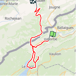
Trail Walking of 31 km to be discovered at Vaud, District du Jura-Nord vaudois, Vallorbe. This trail is proposed by BM25.
Description
vallorbe, grottes grotte aux fees juraparc dent de vaulion. le pont lac des brenets juraparco.t d'or par la petite échelle cabane de la gym , cas et les cretes jusqu'au sommet et descente sur Metabief
Positioning
Country:
Switzerland
Region :
Vaud
Department/Province :
District du Jura-Nord vaudois
Municipality :
Vallorbe
Location:
Unknown
Start:(Dec)
Start:(UTM)
299328 ; 5176212 (32T) N.
Comments
Trails nearby
![Trail Mountain bike Vallorbe - Le Suchet - Photo](https://media.geolcdn.com/t/375/260/ext.jpg?maxdim=2&url=https%3A%2F%2Fstatic1.geolcdn.com%2Fsiteimages%2Fupload%2Ffiles%2F1524743154velo.jpg)
![Mountain bike Mountain bike](https://static1.geolcdn.com/sitytour/trail-icons/202.png)
Le Suchet
Mountain bike
Very easy
(1)
Vallorbe,
Vaud,
District du Jura-Nord vaudois,
Switzerland
![](/images/other/stat-length.png)
35 km | 53 km-effort
14h 41min
![](https://static1.geolcdn.com/siteimages/upload/files/16400158638029165_repeat_loop_refresh_sync_direction_icon.png)
Yes
![Trail On foot Vallorbe - Mont d'Orzeires - Le Pont Gare - Photo](https://media.geolcdn.com/t/375/260/ext.jpg?maxdim=2&url=https%3A%2F%2Fmedia.geolcdn.com%2Ff%2F7e9156be-5722-477c-ab77-407a4f623ffb.jpeg)
![On foot On foot](https://static1.geolcdn.com/sitytour/trail-icons/100.png)
Mont d'Orzeires - Le Pont Gare
On foot
Easy
Vallorbe,
Vaud,
District du Jura-Nord vaudois,
Switzerland
![](/images/other/stat-length.png)
3.2 km | 4.4 km-effort
59min
![](https://static1.geolcdn.com/siteimages/upload/files/16400158638029165_repeat_loop_refresh_sync_direction_icon.png)
No
![Trail On foot Ballaigues - Ballaigues-Vallorbe - Photo](https://media.geolcdn.com/t/375/260/ext.jpg?maxdim=2&url=https%3A%2F%2Fmedia.geolcdn.com%2Ff%2F94e39ae2-cd96-4289-ab6b-b58b7f70c35d.jpeg)
![On foot On foot](https://static1.geolcdn.com/sitytour/trail-icons/100.png)
Ballaigues-Vallorbe
On foot
Easy
Ballaigues,
Vaud,
District du Jura-Nord vaudois,
Switzerland
![](/images/other/stat-length.png)
5.1 km | 6.3 km-effort
1h 25min
![](https://static1.geolcdn.com/siteimages/upload/files/16400158638029165_repeat_loop_refresh_sync_direction_icon.png)
No
![Trail On foot Vallorbe - Saigne Geret-Les Revines - Photo](https://media.geolcdn.com/t/375/260/ext.jpg?maxdim=2&url=https%3A%2F%2Fmedia.geolcdn.com%2Ff%2F7e9156be-5722-477c-ab77-407a4f623ffb.jpeg)
![On foot On foot](https://static1.geolcdn.com/sitytour/trail-icons/100.png)
Saigne Geret-Les Revines
On foot
Easy
Vallorbe,
Vaud,
District du Jura-Nord vaudois,
Switzerland
![](/images/other/stat-length.png)
3.5 km | 4.1 km-effort
56min
![](https://static1.geolcdn.com/siteimages/upload/files/16400158638029165_repeat_loop_refresh_sync_direction_icon.png)
No
![Trail On foot Juriens - TP Mollendruz - Romainmôtie - Photo](https://media.geolcdn.com/t/375/260/ext.jpg?maxdim=2&url=https%3A%2F%2Fmedia.geolcdn.com%2Ff%2Fdev_7316eb13-f07d-4453-9d47-20985e85773c.jpeg)
![On foot On foot](https://static1.geolcdn.com/sitytour/trail-icons/100.png)
TP Mollendruz - Romainmôtie
On foot
Easy
Juriens,
Vaud,
District du Jura-Nord vaudois,
Switzerland
![](/images/other/stat-length.png)
7.8 km | 11.6 km-effort
2h 38min
![](https://static1.geolcdn.com/siteimages/upload/files/16400158638029165_repeat_loop_refresh_sync_direction_icon.png)
No
![Trail Walking L'Abbaye - La Dent de Vaulion - Photo](https://media.geolcdn.com/t/375/260/ext.jpg?maxdim=2&url=https%3A%2F%2Fmedia.geolcdn.com%2Ff%2Fd5e685b7-4a94-4c58-8eef-781dbd85a043.jpg)
![Walking Walking](https://static1.geolcdn.com/sitytour/trail-icons/101.png)
La Dent de Vaulion
Walking
Very difficult
(1)
L'Abbaye,
Vaud,
District du Jura-Nord vaudois,
Switzerland
![](/images/other/stat-length.png)
14.6 km | 22 km-effort
4h 31min
![](https://static1.geolcdn.com/siteimages/upload/files/16400158638029165_repeat_loop_refresh_sync_direction_icon.png)
Yes
![Trail Walking Rochejean - Mont d'or - Photo](https://media.geolcdn.com/t/375/260/ext.jpg?maxdim=2&url=https%3A%2F%2Fmedia.geolcdn.com%2Ff%2F22137291-8125-4d4b-9cc5-d81179db76e3.jpg)
![Walking Walking](https://static1.geolcdn.com/sitytour/trail-icons/101.png)
Mont d'or
Walking
Easy
Rochejean,
Bourgogne-Franche-Comté,
Doubs,
France
![](/images/other/stat-length.png)
11.9 km | 17.5 km-effort
4h 53min
![](https://static1.geolcdn.com/siteimages/upload/files/16400158638029165_repeat_loop_refresh_sync_direction_icon.png)
Yes
![Trail Walking Jougne - La Jougnena - Photo](https://media.geolcdn.com/t/375/260/ext.jpg?maxdim=2&url=https%3A%2F%2Fstatic1.geolcdn.com%2Fsiteimages%2Fupload%2Ffiles%2F1553511878bg_sport_marche.png)
![Walking Walking](https://static1.geolcdn.com/sitytour/trail-icons/101.png)
La Jougnena
Walking
Very difficult
(1)
Jougne,
Bourgogne-Franche-Comté,
Doubs,
France
![](/images/other/stat-length.png)
17.7 km | 24 km-effort
5h 32min
![](https://static1.geolcdn.com/siteimages/upload/files/16400158638029165_repeat_loop_refresh_sync_direction_icon.png)
Yes
![Trail Snowshoes L'Abbaye - Le Pont dent de Vaulion Suisse - Photo](https://media.geolcdn.com/t/375/260/ext.jpg?maxdim=2&url=https%3A%2F%2Fmedia.geolcdn.com%2Ff%2F9e2200ad-9d42-4562-b83d-ca6468e63af4.jpg)
![Snowshoes Snowshoes](https://static1.geolcdn.com/sitytour/trail-icons/504.png)
Le Pont dent de Vaulion Suisse
Snowshoes
Very easy
L'Abbaye,
Vaud,
District du Jura-Nord vaudois,
Switzerland
![](/images/other/stat-length.png)
16.1 km | 24 km-effort
4h 20min
![](https://static1.geolcdn.com/siteimages/upload/files/16400158638029165_repeat_loop_refresh_sync_direction_icon.png)
Yes