Trail Walking Tsingoni - Cascade de soulou - Combani - Photo

Cascade de soulou - Combani

 fsaysset
fsaysset

User

© OpenStreetMap contributors
Length
Length
15.1 km
Max alt
Max alt
128 m
Uphill gradient
Uphill gradient
336 m
Km-Effort
Km-Effort  
19.6 km
Min alt
Min alt
8 m
Downhill gradient
Downhill gradient
337 m
Boucle
Boucle
No
Creation date :
2019-09-26 06:24:00.0
Updated on :
2019-09-26 12:55:39.53

(0 Reviews)

Walking
Walking
4h30
Difficulty : Medium

Scan this QR Code to open this trail in the SityTrail application

FREE GPS app for hiking

Logo SityTrail SityTrail

IGN / Geographical institutes

Download SityTrail from the App Store Download SityTrail from Google Play

Logo SityTrail SityTrail World

The world is yours!

Download SityTrail from the App Store Download SityTrail from Google Play Download SityTrail on Huawei AppGallery

About

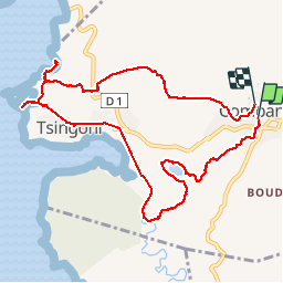
Trail Walking of 15.1 km to be discovered at Mayotte, Unknown, Tsingoni. This trail is proposed by fsaysset.

Description

Boucle de Combani vers la cascade de soulou

Elevation profile

Photos

Positioning

Country:
France
Region :
Mayotte
Department/Province :
Unknown
Municipality :
Tsingoni
Location:
Unknown
Start:(UTM)
514464 ; 8586234 (38L) S.

Trails nearby

Trail Trail Mamoudzou - Traversée S-N Jour 2 - Option2 - Photo
Trail
gromain1000

Trail

Medium
Mamoudzou, Mayotte, Unknown, France
38 km | 58 km-effort
5h 0min
No
Trail Walking Tsingoni - Mont Combarieu - Photo
Walking
fsaysset

Walking

Difficult
Tsingoni, Mayotte, Unknown, France
7.5 km | 11.4 km-effort
1h 59min
No
Trail Mountain bike Tsingoni - retenu collinaire - Photo
Mountain bike
Pascalbahuaud

Mountain bike

Easy
Tsingoni, Mayotte, Unknown, France
1.1 km | 1.3 km-effort
21min
No


Close
My subscriptions