![](/images/other/stat-length.png)
![Trail Walking Daverdisse - Almache - Photo](https://media.geolcdn.com/t/1900/400/ext.pjpeg?maxdim=2&url=https%3A%2F%2Fstatic1.geolcdn.com%2Fsiteimages%2Fupload%2Ffiles%2F1553511878bg_sport_marche.png)
Almache
BruChan
User
![Length](/images/other/stat-length.png)
Length
11.4 km
![Max alt](https://static1.geolcdn.com/siteimages/upload/files/1508320355ic_sort_altitude_max_24dp.png)
Max alt
414 m
![Uphill gradient](https://static1.geolcdn.com/siteimages/upload/files/1508320355ic_sort_den_pos_24dp.png)
Uphill gradient
242 m
![Km-Effort](/images/other/stat-length.png)
Km-Effort
14.6 km
![Min alt](https://static1.geolcdn.com/siteimages/upload/files/1508320355ic_sort_altitude_min_24dp.png)
Min alt
248 m
![Downhill gradient](https://static1.geolcdn.com/siteimages/upload/files/1508320355ic_sort_den_neg_24dp.png)
Downhill gradient
235 m
![Boucle](https://static1.geolcdn.com/siteimages/upload/files/16400158638029165_repeat_loop_refresh_sync_direction_icon.png)
Boucle
Yes
Creation date :
2014-12-10 00:00:00.0
Updated on :
2014-12-10 00:00:00.0
![Walking](https://static1.geolcdn.com/sitytour/trail-icons/101.png)
3h12
Difficulty : Medium
![Scan this QR Code to open this trail in the SityTrail application](https://capi.geolives.com/qq0zvz2zws4bq2lad0pu/sitytour/trails/221386/qr.png?size=200)
FREE GPS app for hiking
About
Trail Walking of 11.4 km to be discovered at Wallonia, Luxembourg, Daverdisse. This trail is proposed by BruChan.
Description
Une randonnée en boucle qui part et revient à Daverdisse en passant près de Gembes
Source:
http://www.circuits-de-belgique.be/circuit--La-vallee-de-lAlmache-a-Daverdisse-fr-7136.php
Positioning
Country:
Belgium
Region :
Wallonia
Department/Province :
Luxembourg
Municipality :
Daverdisse
Location:
Daverdisse
Start:(Dec)
Start:(UTM)
651730 ; 5543169 (31U) N.
Comments
Trails nearby
![Trail Walking Libin - Lesse - Promenade de la Lesse (LI06) - Photo](https://media.geolcdn.com/t/375/260/27528ace-a0b8-4107-8825-6100f3450bfd.jpg&format=jpg&maxdim=2)
![Walking Walking](https://static1.geolcdn.com/sitytour/trail-icons/101.png)
Lesse - Promenade de la Lesse (LI06)
Walking
Medium
(6)
Libin,
Wallonia,
Luxembourg,
Belgium
![](/images/other/stat-length.png)
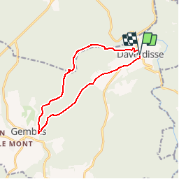
8.6 km | 11.3 km-effort
2h 26min
![](https://static1.geolcdn.com/siteimages/upload/files/16400158638029165_repeat_loop_refresh_sync_direction_icon.png)
Yes
![Trail Walking Daverdisse - Porcheresse Grinchi - Photo](https://media.geolcdn.com/t/375/260/60793136-a8a5-412f-98a4-b91886d74636.jpg&format=jpg&maxdim=2)
![Walking Walking](https://static1.geolcdn.com/sitytour/trail-icons/101.png)
Porcheresse Grinchi
Walking
Medium
(1)
Daverdisse,
Wallonia,
Luxembourg,
Belgium
![](/images/other/stat-length.png)
7.1 km | 9.3 km-effort
2h 6min
![](https://static1.geolcdn.com/siteimages/upload/files/16400158638029165_repeat_loop_refresh_sync_direction_icon.png)
Yes
![Trail Walking Libin - Du village de Redu au hameau de Lesse - Photo](https://media.geolcdn.com/t/375/260/ext.jpg?maxdim=2&url=https%3A%2F%2Fservices.sitytrail.com%2FGeolivesWS%2FDownloadMedia.ashx%3FTrailID%3D449318%26Media%3D3daffb28-a541-4d0a-b434-13b6750e6d2d.JPG)
![Walking Walking](https://static1.geolcdn.com/sitytour/trail-icons/101.png)
Du village de Redu au hameau de Lesse
Walking
Easy
(3)
Libin,
Wallonia,
Luxembourg,
Belgium
![](/images/other/stat-length.png)
11.3 km | 14.9 km-effort
3h 13min
![](https://static1.geolcdn.com/siteimages/upload/files/16400158638029165_repeat_loop_refresh_sync_direction_icon.png)
Yes
![Trail Walking Libin - Lesse - Entre Lesse et Lomme - Photo](https://media.geolcdn.com/t/375/260/29de6fa8-4c44-40a4-a5ee-a6e3f0f650e2.jpg&format=jpg&maxdim=2)
![Walking Walking](https://static1.geolcdn.com/sitytour/trail-icons/101.png)
Lesse - Entre Lesse et Lomme
Walking
Very difficult
(2)
Libin,
Wallonia,
Luxembourg,
Belgium
![](/images/other/stat-length.png)
79 km | 102 km-effort
23h 15min
![](https://static1.geolcdn.com/siteimages/upload/files/16400158638029165_repeat_loop_refresh_sync_direction_icon.png)
Yes
![Trail Walking Libin - Redu - La Virée des Croix - Photo](https://media.geolcdn.com/t/375/260/ext.jpg?maxdim=2&url=https%3A%2F%2Fservices.sitytrail.com%2FGeolivesWS%2FDownloadMedia.ashx%3FTrailID%3D334581%26Media%3D577140e5-7a9b-4e16-8501-3973c972819c.JPG)
![Walking Walking](https://static1.geolcdn.com/sitytour/trail-icons/101.png)
Redu - La Virée des Croix
Walking
Medium
(5)
Libin,
Wallonia,
Luxembourg,
Belgium
![](/images/other/stat-length.png)
6.1 km | 8.2 km-effort
1h 44min
![](https://static1.geolcdn.com/siteimages/upload/files/16400158638029165_repeat_loop_refresh_sync_direction_icon.png)
Yes
![Trail Walking Daverdisse - Porcheresse - Le Gros Bois (P1) - Photo](https://media.geolcdn.com/t/375/260/ext.jpg?maxdim=2&url=https%3A%2F%2Fservices.sitytrail.com%2FGeolivesWS%2FDownloadMedia.ashx%3FTrailID%3D334464%26Media%3D63060b0b-b07c-4065-a8bb-125fd5bf9bab.jpg)
![Walking Walking](https://static1.geolcdn.com/sitytour/trail-icons/101.png)
Porcheresse - Le Gros Bois (P1)
Walking
Medium
(4)
Daverdisse,
Wallonia,
Luxembourg,
Belgium
![](/images/other/stat-length.png)
7 km | 9.4 km-effort
2h 2min
![](https://static1.geolcdn.com/siteimages/upload/files/16400158638029165_repeat_loop_refresh_sync_direction_icon.png)
Yes
![Trail Walking Libin - Adeps 5 kms Redu le 25-08-2024 - Photo](https://media.geolcdn.com/t/375/260/28243488-2727-4746-b790-8170a6922936.jpg&format=jpg&maxdim=2)
![Walking Walking](https://static1.geolcdn.com/sitytour/trail-icons/101.png)
Adeps 5 kms Redu le 25-08-2024
Walking
Medium
(1)
Libin,
Wallonia,
Luxembourg,
Belgium
![](/images/other/stat-length.png)
5.4 km | 7 km-effort
1h 35min
![](https://static1.geolcdn.com/siteimages/upload/files/16400158638029165_repeat_loop_refresh_sync_direction_icon.png)
Yes
![Trail Walking Libin - Lesse - Virée à Chène (LI08) - Photo](https://media.geolcdn.com/t/375/260/90bf87f0-b495-4e76-bcdc-cb0533bbc55d.jpg&format=jpg&maxdim=2)
![Walking Walking](https://static1.geolcdn.com/sitytour/trail-icons/101.png)
Lesse - Virée à Chène (LI08)
Walking
Easy
(6)
Libin,
Wallonia,
Luxembourg,
Belgium
![](/images/other/stat-length.png)
5.7 km | 7.7 km-effort
1h 43min
![](https://static1.geolcdn.com/siteimages/upload/files/16400158638029165_repeat_loop_refresh_sync_direction_icon.png)
Yes
![Trail Walking Libin - Redu - Le passage des chèvres (LI05) - Photo](https://media.geolcdn.com/t/375/260/b2dc792e-d456-4607-89dc-d784f8062161.jpg&format=jpg&maxdim=2)
![Walking Walking](https://static1.geolcdn.com/sitytour/trail-icons/101.png)
Redu - Le passage des chèvres (LI05)
Walking
Medium
(5)
Libin,
Wallonia,
Luxembourg,
Belgium
![](/images/other/stat-length.png)
8.1 km | 10.7 km-effort
2h 24min
![](https://static1.geolcdn.com/siteimages/upload/files/16400158638029165_repeat_loop_refresh_sync_direction_icon.png)
Yes