Trail Mountain bike Yvoir - GODINNE ... Dinant, par la Montagne de la Croix. - Photo

GODINNE ... Dinant, par la Montagne de la Croix.

© OpenStreetMap contributors
Length
Length
38 km
Max alt
Max alt
260 m
Uphill gradient
Uphill gradient
721 m
Km-Effort
Km-Effort  
48 km
Min alt
Min alt
62 m
Downhill gradient
Downhill gradient
720 m
Boucle
Boucle
Yes
Creation date :
2019-09-24 07:26:13.071
Updated on :
2019-09-25 07:14:36.49

(0 Reviews)

Mountain bike
Mountain bike
2h42
Difficulty : Medium

Scan this QR Code to open this trail in the SityTrail application

FREE GPS app for hiking

Logo SityTrail SityTrail

IGN / Geographical institutes

Download SityTrail from the App Store Download SityTrail from Google Play

Logo SityTrail SityTrail World

The world is yours!

Download SityTrail from the App Store Download SityTrail from Google Play Download SityTrail on Huawei AppGallery

About

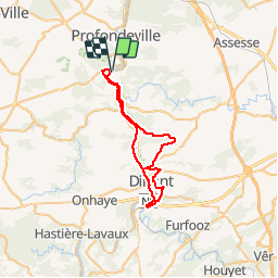
Trail Mountain bike of 38 km to be discovered at Wallonia, Namur, Yvoir. This trail is proposed by GerardBouche.

Description

D'abord par la rive droite de la Meuse jusque HOUX puis un sentier forestier par le Mont d'Houx , l'entrée du village d'Awagne, les carrières de Montorgueil avant de rejoindre les Fonds de Leffe. Depuis l'Abbaye de Leffe une montée jusqu'au lieu dit Malaise, le Pont d'Amour, la Montagne de la Croix , l'observatoire et descente vers le Froidvau. Par le pont St-Jean, traverser la Meuse à l'écluse et par un petit sentier retrouver le hameau de Neffe, le lieu dit Bethléem et retour par la rive gauche de la Meuse.

Elevation profile

Photos

Positioning

Country:
Belgium
Region :
Wallonia
Department/Province :
Namur
Municipality :
Yvoir
Location:
Godinne
Start:(UTM)
632602 ; 5578887 (31U) N.

Trails nearby

Trail Walking Profondeville - GG-Na-19_ Lustin - Namur - Photo
Walking
PRO

Walking

Very difficult
(13)
Profondeville, Wallonia, Namur, Belgium
22 km | 28 km-effort
6h 7min
No
Trail Walking Anhée - RB-Na-22-raccourci_Vignobles-et-Jardins-d’eau - Photo
Walking
PRO

Walking

Very difficult
(6)
Anhée, Wallonia, Namur, Belgium
16.7 km | 21 km-effort
4h 52min
Yes
Trail Walking Anhée - RB-Na-22_Vignobles-et-Jardins-d’eau - Photo
Walking
PRO

Walking

Very difficult
(11)
Anhée, Wallonia, Namur, Belgium
19.5 km | 25 km-effort
5h 46min
Yes
Trail Walking Yvoir - RB-Na-21-Terres seigneuriales et carrières de la vallée du Bocq - Photo
Walking
PRO

Walking

Very difficult
(6)
Yvoir, Wallonia, Namur, Belgium
22 km | 30 km-effort
6h 51min
Yes
Trail Walking Profondeville - RB-Na-20-Raccourci-2_Paysages_entre_Meuse_et_Burnot - Photo
Walking
PRO

Walking

Very difficult
(11)
Profondeville, Wallonia, Namur, Belgium
14.6 km | 22 km-effort
4h 53min
Yes
Trail Walking Profondeville - RB-Na-20-Paysages_entre_Meuse_et_Burnot - Photo
Walking
PRO

Walking

Very difficult
(16)
Profondeville, Wallonia, Namur, Belgium
18.5 km | 26 km-effort
5h 55min
Yes
Trail Walking Yvoir - RB-Na-03 Forteresses, citadelle et abbaye mosanes - Photo
Walking
PRO

Walking

Difficult
(11)
Yvoir, Wallonia, Namur, Belgium
22 km | 30 km-effort
7h 1min
Yes
Trail Walking Yvoir - GG2-Na-38_Godinne-Dinant (2021-11-04) - Photo
Walking
PRO

Walking

Very difficult
(6)
Yvoir, Wallonia, Namur, Belgium
19.5 km | 27 km-effort
6h 13min
No
Trail Walking Anhée - RF-Na-05 Annevoie, côté Jardins_Grande-boucle - Photo
Walking
PRO

Walking

Medium
(11)
Anhée, Wallonia, Namur, Belgium
11.3 km | 14.5 km-effort
3h 6min
Yes


Close
My subscriptions