Trail Walking La Plagne-Tarentaise - Move - Photo
 chuck
chuck

User

© OpenStreetMap contributors
Length
Length
4.1 km
Max alt
Max alt
2008 m
Uphill gradient
Uphill gradient
2 m
Km-Effort
Km-Effort  
5.5 km
Min alt
Min alt
1594 m
Downhill gradient
Downhill gradient
408 m
Boucle
Boucle
No
Creation date :
2019-09-23 09:25:15.058
Updated on :
2019-09-23 09:48:41.941

(0 Reviews)

Walking
Walking
56m
Difficulty : Easy

Scan this QR Code to open this trail in the SityTrail application

FREE GPS app for hiking

Logo SityTrail SityTrail

IGN / Geographical institutes

Download SityTrail from the App Store Download SityTrail from Google Play

Logo SityTrail SityTrail World

The world is yours!

Download SityTrail from the App Store Download SityTrail from Google Play Download SityTrail on Huawei AppGallery

About

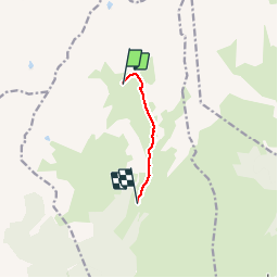
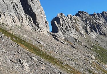
Trail Walking of 4.1 km to be discovered at Auvergne-Rhône-Alpes, Savoy, La Plagne-Tarentaise. This trail is proposed by chuck.

Description

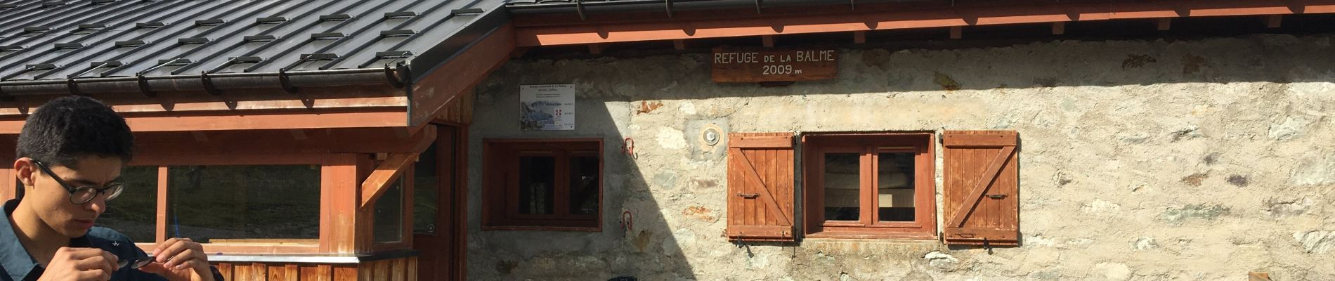
Refuge communal de la Balme au parking de la Chapelle Saint Guérin

Elevation profile

Photos

Positioning

Country:
France
Region :
Auvergne-Rhône-Alpes
Department/Province :
Savoy
Municipality :
La Plagne-Tarentaise
Location:
La Côte-d'Aime
Start:(UTM)
318325 ; 5055813 (32T) N.

Trails nearby

Trail Walking Aime-la-Plagne - 2024-09-08 Marche Tour Beaufortain Refuge Coire vers Refuge Presset - Photo
Walking
GUIDE
holtzv

Walking

Very difficult
Aime-la-Plagne, Auvergne-Rhône-Alpes, Savoy, France
13.6 km | 26 km-effort
5h 48min
No
Trail Walking La Plagne-Tarentaise - suuntoapp-Hiking-2024-09-09T06-09-09Z - Photo
Walking
GUIDE
holtzv

Walking

Very difficult
La Plagne-Tarentaise, Auvergne-Rhône-Alpes, Savoy, France
13.6 km | 25 km-effort
5h 44min
No
Trail Walking La Plagne-Tarentaise - 73 Tarentaise Col du Mont Rosset Refuge de la Balme-Col et Charbonnière Lac de la Portette  - Photo
Walking
Maryma

Walking

Very difficult
(1)
La Plagne-Tarentaise, Auvergne-Rhône-Alpes, Savoy, France
14.5 km | 31 km-effort
6h 56min
Yes
Trail Touring skiing La Plagne-Tarentaise - La Chaille. col à l'ouest du Rocher st Laurent - Photo
Touring skiing
GUIDE
nadd73

Touring skiing

Easy
La Plagne-Tarentaise, Auvergne-Rhône-Alpes, Savoy, France
13.9 km | 29 km-effort
6h 38min
Yes
Trail Walking Beaufort - lac de Presset et passeur de la Mintaz (belvédère de la Pierra Menta) - Photo
Walking
GUIDE
amiral13

Walking

Difficult
Beaufort, Auvergne-Rhône-Alpes, Savoy, France
11.6 km | 24 km-effort
2h 57min
Yes
Trail Walking La Plagne-Tarentaise - Du refuge de Presset au refuge de la Coire - Photo
Walking
GUIDE
Desrumaux

Walking

Medium
La Plagne-Tarentaise, Auvergne-Rhône-Alpes, Savoy, France
9 km | 15.6 km-effort
5h 0min
No
Trail Walking Beaufort - Lac d’Amour - col du Coin 10 km -680 m dénivelé + - Photo
Walking
GUIDE
rvapeldo

Walking

Medium
Beaufort, Auvergne-Rhône-Alpes, Savoy, France
10.4 km | 19.6 km-effort
7h 5min
Yes
Trail Walking Beaufort - Brèche de Parozan - Photo
Walking
GuyVachet

Walking

Very difficult
Beaufort, Auvergne-Rhône-Alpes, Savoy, France
9.6 km | 23 km-effort
4h 29min
Yes
Trail Walking La Plagne-Tarentaise - BEAUFORTIN: DU REFUGE DE PRESSET A TREICOL - Photo
Walking
djeepee74

Walking

Difficult
La Plagne-Tarentaise, Auvergne-Rhône-Alpes, Savoy, France
19 km | 31 km-effort
5h 55min
No


Close
My subscriptions