![](/images/other/stat-length.png)
![Trail Walking Μακρυνίτσα - Gréce, Makrinitsa Volos retour - Photo](https://media.geolcdn.com/t/1900/400/3fa50430-e3a8-4ddf-b770-93f1dc9c5e5e.jpg&format=pjpeg&maxdim=2)
Gréce, Makrinitsa Volos retour
jopost
User
![Length](/images/other/stat-length.png)
Length
10.5 km
![Max alt](https://static1.geolcdn.com/siteimages/upload/files/1508320355ic_sort_altitude_max_24dp.png)
Max alt
730 m
![Uphill gradient](https://static1.geolcdn.com/siteimages/upload/files/1508320355ic_sort_den_pos_24dp.png)
Uphill gradient
164 m
![Km-Effort](/images/other/stat-length.png)
Km-Effort
14.5 km
![Min alt](https://static1.geolcdn.com/siteimages/upload/files/1508320355ic_sort_altitude_min_24dp.png)
Min alt
28 m
![Downhill gradient](https://static1.geolcdn.com/siteimages/upload/files/1508320355ic_sort_den_neg_24dp.png)
Downhill gradient
726 m
![Boucle](https://static1.geolcdn.com/siteimages/upload/files/16400158638029165_repeat_loop_refresh_sync_direction_icon.png)
Boucle
No
Creation date :
2019-09-20 14:13:26.036
Updated on :
2019-10-01 18:17:32.572
![Walking](https://static1.geolcdn.com/sitytour/trail-icons/101.png)
3h45
Difficulty : Easy
![Scan this QR Code to open this trail in the SityTrail application](https://capi.geolives.com/qq0zvz2zws4bq2lad0pu/sitytour/trails/2209836/qr.png?size=200)
FREE GPS app for hiking
About
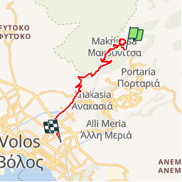
Trail Walking of 10.5 km to be discovered at Thessaly and Central Greece, Regional Unit of Magnesia. This trail is proposed by jopost.
Description
Prendre le bus à Volos pour 2 euros jusqu'à Makrinista puis promenez vous et redecendez, pour ma part, nous avons attendu le coucher de soleil et donc avons pris la route mais vous avez la possibilité de prendre les sentiers qui coupent, aidez vous de google Maps.
Positioning
Country:
Greece
Region :
Thessaly and Central Greece
Department/Province :
Regional Unit of Magnesia
Municipality :
Μακρυνίτσα
Location:
Unknown
Start:(Dec)
Start:(UTM)
671523 ; 4363080 (34S) N.
Comments
Trails nearby
![Trail Running - footing chorefto - Photo](https://media.geolcdn.com/t/375/260/ext.jpg?maxdim=2&url=https%3A%2F%2Fstatic1.geolcdn.com%2Fsiteimages%2Fupload%2Ffiles%2F1524743154running.jpg)
![Running Running](https://static1.geolcdn.com/sitytour/trail-icons/103.png)
footing chorefto
Running
Very easy
,
Thessaly and Central Greece,
Regional Unit of Magnesia,
Greece
![](/images/other/stat-length.png)
3.9 km | 4.9 km-effort
29min
![](https://static1.geolcdn.com/siteimages/upload/files/16400158638029165_repeat_loop_refresh_sync_direction_icon.png)
Yes