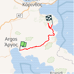
![Trail Cycle Municipal Unit of Nafplio - Naupli1 - Photo](https://media.geolcdn.com/t/1900/400/ext.pjpeg?maxdim=2&url=https%3A%2F%2Fstatic1.geolcdn.com%2Fsiteimages%2Fupload%2Ffiles%2F1524743154velo.jpg)
Naupli1
guy39
User
![Length](/images/other/stat-length.png)
Length
64 km
![Max alt](https://static1.geolcdn.com/siteimages/upload/files/1508320355ic_sort_altitude_max_24dp.png)
Max alt
358 m
![Uphill gradient](https://static1.geolcdn.com/siteimages/upload/files/1508320355ic_sort_den_pos_24dp.png)
Uphill gradient
1115 m
![Km-Effort](/images/other/stat-length.png)
Km-Effort
78 km
![Min alt](https://static1.geolcdn.com/siteimages/upload/files/1508320355ic_sort_altitude_min_24dp.png)
Min alt
-1 m
![Downhill gradient](https://static1.geolcdn.com/siteimages/upload/files/1508320355ic_sort_den_neg_24dp.png)
Downhill gradient
1118 m
![Boucle](https://static1.geolcdn.com/siteimages/upload/files/16400158638029165_repeat_loop_refresh_sync_direction_icon.png)
Boucle
No
Creation date :
2019-09-20 05:19:56.073
Updated on :
2019-09-20 05:40:14.025
![Cycle](https://static1.geolcdn.com/sitytour/trail-icons/200.png)
--
Difficulty : Medium
![Scan this QR Code to open this trail in the SityTrail application](https://capi.geolives.com/qq0zvz2zws4bq2lad0pu/sitytour/trails/2209105/qr.png?size=200)
FREE GPS app for hiking
About
Trail Cycle of 64 km to be discovered at Peloponnese, Western Greece and the Ionian, Argolis Regional Unit, Municipal Unit of Nafplio. This trail is proposed by guy39.
Description
velo route
Positioning
Country:
Greece
Region :
Peloponnese, Western Greece and the Ionian
Department/Province :
Argolis Regional Unit
Municipality :
Municipal Unit of Nafplio
Location:
Community of Nafplio
Start:(Dec)
Start:(UTM)
659730 ; 4159356 (34S) N.
Comments
Trails nearby