![](/images/other/stat-length.png)
![Trail Walking Begur - Begur randonnée verte - Photo](https://media.geolcdn.com/t/1900/400/ext.pjpeg?maxdim=2&url=https%3A%2F%2Fstatic1.geolcdn.com%2Fsiteimages%2Fupload%2Ffiles%2F1553511878bg_sport_marche.png)
Begur randonnée verte
jciclc
User
![Length](/images/other/stat-length.png)
Length
11.2 km
![Max alt](https://static1.geolcdn.com/siteimages/upload/files/1508320355ic_sort_altitude_max_24dp.png)
Max alt
244 m
![Uphill gradient](https://static1.geolcdn.com/siteimages/upload/files/1508320355ic_sort_den_pos_24dp.png)
Uphill gradient
348 m
![Km-Effort](/images/other/stat-length.png)
Km-Effort
15.9 km
![Min alt](https://static1.geolcdn.com/siteimages/upload/files/1508320355ic_sort_altitude_min_24dp.png)
Min alt
4 m
![Downhill gradient](https://static1.geolcdn.com/siteimages/upload/files/1508320355ic_sort_den_neg_24dp.png)
Downhill gradient
345 m
![Boucle](https://static1.geolcdn.com/siteimages/upload/files/16400158638029165_repeat_loop_refresh_sync_direction_icon.png)
Boucle
Yes
Creation date :
2019-09-17 07:49:20.0
Updated on :
2019-09-18 15:49:27.623
![Walking](https://static1.geolcdn.com/sitytour/trail-icons/101.png)
3h48
Difficulty : Very difficult
![Scan this QR Code to open this trail in the SityTrail application](https://capi.geolives.com/qq0zvz2zws4bq2lad0pu/sitytour/trails/2207814/qr.png?size=200)
FREE GPS app for hiking
About
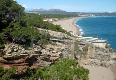
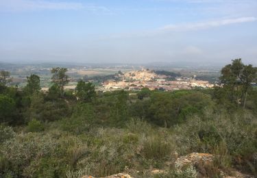
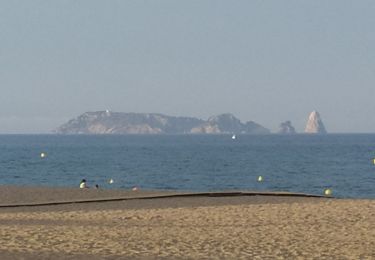
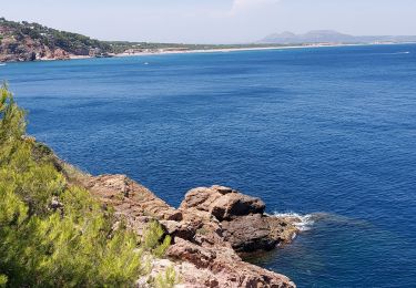
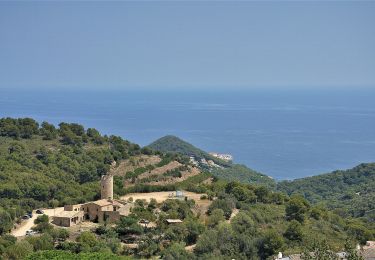
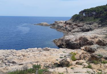
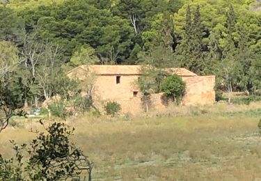
Trail Walking of 11.2 km to be discovered at Catalonia, Girona, Begur. This trail is proposed by jciclc.
Description
Belle randonnée autour de Begur selon suggestion de la commune. Nous avons toutefois bouclé la route (au lieu de remonter vers Begur) en longeant la côte sur les rochers. Pas pour débutants
Positioning
Country:
Spain
Region :
Catalonia
Department/Province :
Girona
Municipality :
Begur
Location:
Unknown
Start:(Dec)
Start:(UTM)
517109 ; 4645735 (31T) N.
Comments
Trails nearby
![Trail Walking Begur - platja de Pals - Cap Begur - Photo](https://media.geolcdn.com/t/375/260/23e6d693-57e0-45a1-b8d4-faf71b452e70.jpg&format=jpg&maxdim=2)
![Walking Walking](https://static1.geolcdn.com/sitytour/trail-icons/101.png)
platja de Pals - Cap Begur
Walking
Medium
Begur,
Catalonia,
Girona,
Spain
![](/images/other/stat-length.png)
17.6 km | 26 km-effort
5h 10min
![](https://static1.geolcdn.com/siteimages/upload/files/16400158638029165_repeat_loop_refresh_sync_direction_icon.png)
Yes
![Trail Walking Begur - Sa Riera 220722 - Photo](https://media.geolcdn.com/t/375/260/31931d9a-6c96-4724-99c1-7d96f03900c4.jpg&format=jpg&maxdim=2)
![Walking Walking](https://static1.geolcdn.com/sitytour/trail-icons/101.png)
Sa Riera 220722
Walking
Difficult
Begur,
Catalonia,
Girona,
Spain
![](/images/other/stat-length.png)
11.4 km | 16.4 km-effort
4h 52min
![](https://static1.geolcdn.com/siteimages/upload/files/16400158638029165_repeat_loop_refresh_sync_direction_icon.png)
No
![Trail On foot Begur - SL-C 23 reserva marina de Ses Negres - Photo](https://media.geolcdn.com/t/375/260/3fb2b13c-ba9a-4f49-9c7d-7611bd3f1fa0.jpeg&format=jpg&maxdim=2)
![On foot On foot](https://static1.geolcdn.com/sitytour/trail-icons/100.png)
SL-C 23 reserva marina de Ses Negres
On foot
Easy
Begur,
Catalonia,
Girona,
Spain
![](/images/other/stat-length.png)
9.9 km | 14.2 km-effort
3h 13min
![](https://static1.geolcdn.com/siteimages/upload/files/16400158638029165_repeat_loop_refresh_sync_direction_icon.png)
Yes
![Trail Walking Palafrugell - de Tamariu àcala Pedrosa. - Photo](https://media.geolcdn.com/t/375/260/84442707-0b0f-40c9-8278-29a09e98deb7.jpg&format=jpg&maxdim=2)
![Walking Walking](https://static1.geolcdn.com/sitytour/trail-icons/101.png)
de Tamariu àcala Pedrosa.
Walking
Medium
Palafrugell,
Catalonia,
Girona,
Spain
![](/images/other/stat-length.png)
3.7 km | 5 km-effort
1h 15min
![](https://static1.geolcdn.com/siteimages/upload/files/16400158638029165_repeat_loop_refresh_sync_direction_icon.png)
Yes
![Trail Walking Begur - Begur randonnée rouge gr22 - Photo](https://media.geolcdn.com/t/375/260/7d69d149-be67-4832-b8a1-4d7e29e720fb.jpg&format=jpg&maxdim=2)
![Walking Walking](https://static1.geolcdn.com/sitytour/trail-icons/101.png)
Begur randonnée rouge gr22
Walking
Very difficult
Begur,
Catalonia,
Girona,
Spain
![](/images/other/stat-length.png)
18.2 km | 28 km-effort
4h 52min
![](https://static1.geolcdn.com/siteimages/upload/files/16400158638029165_repeat_loop_refresh_sync_direction_icon.png)
Yes
![Walking Walking](https://static1.geolcdn.com/sitytour/trail-icons/101.png)
![Trail Walking Pals - Pals - Photo](https://media.geolcdn.com/t/375/260/fef183f4-b014-46e1-9804-15acafe6885b.jpg&format=jpg&maxdim=2)
![Walking Walking](https://static1.geolcdn.com/sitytour/trail-icons/101.png)
![Trail sport Begur - Begur jour 1 - Photo](https://media.geolcdn.com/t/375/260/ext.jpg?maxdim=2&url=https%3A%2F%2Fsecurestorage.geolives.com%2Fsitytour%2Ftrail-bg%2Fdefault.jpg)
![Trail Walking Begur - Calas de Begur - Photo](https://media.geolcdn.com/t/375/260/ext.jpg?maxdim=2&url=https%3A%2F%2Fstatic1.geolcdn.com%2Fsiteimages%2Fupload%2Ffiles%2F1553511878bg_sport_marche.png)
![Walking Walking](https://static1.geolcdn.com/sitytour/trail-icons/101.png)