Trail Walking Ergisch - Ergisch et vallée de Tourtemagne - Photo

Ergisch et vallée de Tourtemagne

 duamerg
duamerg

User

© OpenStreetMap contributors
Length
Length
13.5 km
Max alt
Max alt
1790 m
Uphill gradient
Uphill gradient
944 m
Km-Effort
Km-Effort  
26 km
Min alt
Min alt
1057 m
Downhill gradient
Downhill gradient
945 m
Boucle
Boucle
Yes
Creation date :
2014-12-11 00:00:00.0
Updated on :
2020-01-30 13:58:16.655

(0 Reviews)

Walking
Walking
5h00
Difficulty : Medium

Scan this QR Code to open this trail in the SityTrail application

FREE GPS app for hiking

Logo SityTrail SityTrail

IGN / Geographical institutes

Download SityTrail from the App Store Download SityTrail from Google Play

Logo SityTrail SityTrail World

The world is yours!

Download SityTrail from the App Store Download SityTrail from Google Play Download SityTrail on Huawei AppGallery

About

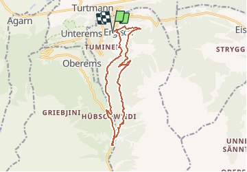
Trail Walking of 13.5 km to be discovered at Valais/Wallis, Leuk, Ergisch. This trail is proposed by duamerg.

Description

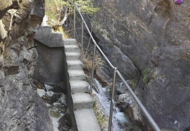
Parquer à l'entrée du village. A l'église suivre les panneaux indiquant Alpetjini. Bon chemin. Etonnante chapelle de St. Anton. A Alpetjini profitez de la vue sur le Weisshorn et les Diablons. Suivre les panneaux des aigles. Descente abrupte vers le fond de la vallée. Traverser la rivière et aller jusqu'à la chapelle de Follutschugge. Retour en longeant la rivière que l'on traverse à nouveau pour tomber sur le bisse d'Ergisch (prudenceà certains endroits) qui nous ramène à notre point de départ. Promenade d'été bien ombragée, la plupart du temps en forêt.

Elevation profile

Positioning

Country:
Switzerland
Region :
Valais/Wallis
Department/Province :
Leuk
Municipality :
Ergisch
Location:
Unknown
Start:(Dec)
Start:(UTM)
400800 ; 5127333 (32T) N.

Trails nearby

Trail Other activity Turtmann-Unterems - y10_stockweg - Photo
Other activity
GUIDE+

Other activity

Very easy
Turtmann-Unterems, Valais/Wallis, Leuk, Switzerland
8 km | 13.7 km-effort
3h 20min
No
Trail Other activity Oberems - y10_oberems_chandolin - Photo
Other activity
GUIDE+

Other activity

Very easy
Oberems, Valais/Wallis, Leuk, Switzerland
13.5 km | 33 km-effort
7h 26min
No
Trail Other activity Oberems - y10_turtmanntal - Photo
Other activity
GUIDE+

Other activity

Very easy
Oberems, Valais/Wallis, Leuk, Switzerland
20 km | 36 km-effort
8h 35min
Yes
Trail Other activity Turtmann-Unterems - y10_baerenpfad_unterems - Photo
Other activity
GUIDE+

Other activity

Very easy
Turtmann-Unterems, Valais/Wallis, Leuk, Switzerland
6.4 km | 11.9 km-effort
2h 55min
No
Trail Walking Steg-Hohtenn - Hohtenn Lalden: Lötschberg-Südrampe - Photo
Walking
GUIDE+

Walking

Very easy
Steg-Hohtenn, Valais/Wallis, Westlich Raron, Switzerland
21 km | 33 km-effort
Unknown
No
Trail Walking Turtmann-Unterems - Turtmanntal: Von Wasserfall zu Wasserfall - Photo
Walking
GUIDE+

Walking

Very easy
Turtmann-Unterems, Valais/Wallis, Leuk, Switzerland
10.1 km | 19.7 km-effort
Unknown
Yes
Trail Walking Steg-Hohtenn - st_koreatv08_03 - Photo
Walking
GUIDE+

Walking

Very easy
Steg-Hohtenn, Valais/Wallis, Westlich Raron, Switzerland
36 km | 105 km-effort
7h 24min
No
Trail Walking Steg-Hohtenn - 2 bisses depuis Hohtenn 06.04.17 - Photo
Walking
duamerg

Walking

Medium
Steg-Hohtenn, Valais/Wallis, Westlich Raron, Switzerland
7.8 km | 12.5 km-effort
2h 59min
Yes
Trail Other activity Steg-Hohtenn - 14 10 09 Alpjoly - Photo
Other activity
mjoseph

Other activity

Very easy
Steg-Hohtenn, Valais/Wallis, Westlich Raron, Switzerland
10.5 km | 22 km-effort
Unknown
Yes


Close
My subscriptions