![](/images/other/stat-length.png)
![Trail Walking Gavarnie-Gèdre - ossoué-baysselance - Photo](https://media.geolcdn.com/t/1900/400/0de77bdd-6548-4f29-9739-e58ce7c58952.jpg&format=pjpeg&maxdim=2)
ossoué-baysselance
pffrench
User
![Length](/images/other/stat-length.png)
Length
7.9 km
![Max alt](https://static1.geolcdn.com/siteimages/upload/files/1508320355ic_sort_altitude_max_24dp.png)
Max alt
2648 m
![Uphill gradient](https://static1.geolcdn.com/siteimages/upload/files/1508320355ic_sort_den_pos_24dp.png)
Uphill gradient
950 m
![Km-Effort](/images/other/stat-length.png)
Km-Effort
17.5 km
![Min alt](https://static1.geolcdn.com/siteimages/upload/files/1508320355ic_sort_altitude_min_24dp.png)
Min alt
1728 m
![Downhill gradient](https://static1.geolcdn.com/siteimages/upload/files/1508320355ic_sort_den_neg_24dp.png)
Downhill gradient
33 m
![Boucle](https://static1.geolcdn.com/siteimages/upload/files/16400158638029165_repeat_loop_refresh_sync_direction_icon.png)
Boucle
No
Creation date :
2019-09-14 09:13:18.2
Updated on :
2019-09-17 10:36:38.688
![Walking](https://static1.geolcdn.com/sitytour/trail-icons/101.png)
5h58
Difficulty : Medium
![Scan this QR Code to open this trail in the SityTrail application](https://capi.geolives.com/qq0zvz2zws4bq2lad0pu/sitytour/trails/2205138/qr.png?size=200)
FREE GPS app for hiking
About
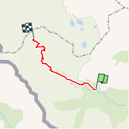
Trail Walking of 7.9 km to be discovered at Occitania, Hautespyrenees, Gavarnie-Gèdre. This trail is proposed by pffrench.
Description
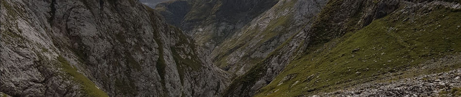
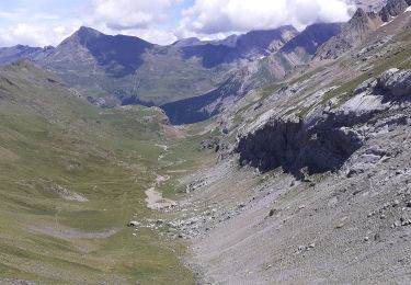
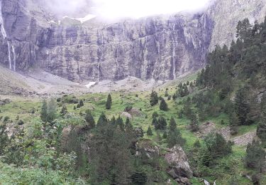
Route de terre menant au barrage d'Ossoué, où se situe le départ. Le refuge est un bon point de départ pour l'ascension du Vignemale, qui n'est pas décrite ici, car elle correspond à une activité d'alpinisme.
Positioning
Country:
France
Region :
Occitania
Department/Province :
Hautespyrenees
Municipality :
Gavarnie-Gèdre
Location:
Gavarnie
Start:(Dec)
Start:(UTM)
738777 ; 4737650 (30T) N.
Comments
Trails nearby
![Trail Walking Torla-Ordesa - Soum Blanc des Espécières-Col des Tentes - Photo](https://media.geolcdn.com/t/375/260/ext.jpg?maxdim=2&url=https%3A%2F%2Fservices.sitytrail.com%2FGeolivesWS%2FDownloadMedia.ashx%3FTrailID%3D218642%26Media%3Dfix__20130902152651.jpg)
![Walking Walking](https://static1.geolcdn.com/sitytour/trail-icons/101.png)
Soum Blanc des Espécières-Col des Tentes
Walking
Difficult
(7)
Torla-Ordesa,
Aragon,
Huesca,
Spain
![](/images/other/stat-length.png)
4 km | 5.7 km-effort
1h 42min
![](https://static1.geolcdn.com/siteimages/upload/files/16400158638029165_repeat_loop_refresh_sync_direction_icon.png)
No
![Trail Walking Gavarnie-Gèdre - Lac de la Bernatoire - Photo](https://media.geolcdn.com/t/375/260/ext.jpg?maxdim=2&url=https%3A%2F%2Fstatic1.geolcdn.com%2Fsiteimages%2Fupload%2Ffiles%2F1553511878bg_sport_marche.png)
![Walking Walking](https://static1.geolcdn.com/sitytour/trail-icons/101.png)
Lac de la Bernatoire
Walking
Medium
(8)
Gavarnie-Gèdre,
Occitania,
Hautespyrenees,
France
![](/images/other/stat-length.png)
12.7 km | 22 km-effort
4h 36min
![](https://static1.geolcdn.com/siteimages/upload/files/16400158638029165_repeat_loop_refresh_sync_direction_icon.png)
Yes
![Trail Walking Gavarnie-Gèdre - Breche de Rolland - Photo](https://media.geolcdn.com/t/375/260/ext.jpg?maxdim=2&url=https%3A%2F%2Fservices.sitytrail.com%2FGeolivesWS%2FDownloadMedia.ashx%3FTrailID%3D334692%26Media%3Dfix__20140811120248.jpg)
![Walking Walking](https://static1.geolcdn.com/sitytour/trail-icons/101.png)
Breche de Rolland
Walking
Easy
(3)
Gavarnie-Gèdre,
Occitania,
Hautespyrenees,
France
![](/images/other/stat-length.png)
12.1 km | 22 km-effort
4h 34min
![](https://static1.geolcdn.com/siteimages/upload/files/16400158638029165_repeat_loop_refresh_sync_direction_icon.png)
Yes
![Trail Walking Gavarnie-Gèdre - Faja de las Flores - Photo](https://media.geolcdn.com/t/375/260/ext.jpg?maxdim=2&url=https%3A%2F%2Fservices.sitytrail.com%2FGeolivesWS%2FDownloadMedia.ashx%3FTrailID%3D102724%26Media%3D3837_6.jpg)
![Walking Walking](https://static1.geolcdn.com/sitytour/trail-icons/101.png)
Faja de las Flores
Walking
Very difficult
(1)
Gavarnie-Gèdre,
Occitania,
Hautespyrenees,
France
![](/images/other/stat-length.png)
22 km | 45 km-effort
13h 0min
![](https://static1.geolcdn.com/siteimages/upload/files/16400158638029165_repeat_loop_refresh_sync_direction_icon.png)
Yes
![Trail Walking Gavarnie-Gèdre - Le Soum Blanc des Especières 2685m depuis le col de Tentes - Photo](https://media.geolcdn.com/t/375/260/ext.jpg?maxdim=2&url=https%3A%2F%2Fservices.sitytrail.com%2FGeolivesWS%2FDownloadMedia.ashx%3FTrailID%3D109867%26Media%3D4854_1.jpg)
![Walking Walking](https://static1.geolcdn.com/sitytour/trail-icons/101.png)
Le Soum Blanc des Especières 2685m depuis le col de Tentes
Walking
Difficult
(2)
Gavarnie-Gèdre,
Occitania,
Hautespyrenees,
France
![](/images/other/stat-length.png)
5.6 km | 12.6 km-effort
3h 0min
![](https://static1.geolcdn.com/siteimages/upload/files/16400158638029165_repeat_loop_refresh_sync_direction_icon.png)
Yes
![Trail Walking Gavarnie-Gèdre - Le Casque du Marboré 3006m depuis le col de Tentes (2208m) - Photo](https://media.geolcdn.com/t/375/260/ext.jpg?maxdim=2&url=https%3A%2F%2Fservices.sitytrail.com%2FGeolivesWS%2FDownloadMedia.ashx%3FTrailID%3D109814%26Media%3D4776_1.jpg)
![Walking Walking](https://static1.geolcdn.com/sitytour/trail-icons/101.png)
Le Casque du Marboré 3006m depuis le col de Tentes (2208m)
Walking
Very difficult
(1)
Gavarnie-Gèdre,
Occitania,
Hautespyrenees,
France
![](/images/other/stat-length.png)
7 km | 16.4 km-effort
7h 0min
![](https://static1.geolcdn.com/siteimages/upload/files/16400158638029165_repeat_loop_refresh_sync_direction_icon.png)
No
![Trail Walking Gavarnie-Gèdre - Brèche de Roland A/R depuis le col de Tentes - Photo](https://media.geolcdn.com/t/375/260/d0dcfe85-baea-4bbf-a123-3b041fed306d.jpg&format=jpg&maxdim=2)
![Walking Walking](https://static1.geolcdn.com/sitytour/trail-icons/101.png)
Brèche de Roland A/R depuis le col de Tentes
Walking
Very difficult
Gavarnie-Gèdre,
Occitania,
Hautespyrenees,
France
![](/images/other/stat-length.png)
13.5 km | 24 km-effort
4h 38min
![](https://static1.geolcdn.com/siteimages/upload/files/16400158638029165_repeat_loop_refresh_sync_direction_icon.png)
Yes
![Trail Walking Gavarnie-Gèdre - Cirque Gavarnie - Photo](https://media.geolcdn.com/t/375/260/6c6bdbe7-fe2c-4036-a187-b055cb6dc229.jpg&format=jpg&maxdim=2)
![Walking Walking](https://static1.geolcdn.com/sitytour/trail-icons/101.png)
Cirque Gavarnie
Walking
Very difficult
Gavarnie-Gèdre,
Occitania,
Hautespyrenees,
France
![](/images/other/stat-length.png)
16.8 km | 28 km-effort
5h 0min
![](https://static1.geolcdn.com/siteimages/upload/files/16400158638029165_repeat_loop_refresh_sync_direction_icon.png)
Yes
![Trail Walking Gavarnie-Gèdre - pic de Lary thmie fait - Photo](https://media.geolcdn.com/t/375/260/f11474bf-48b7-476e-be2b-f85ef1a9b455.jpg&format=jpg&maxdim=2)
![Walking Walking](https://static1.geolcdn.com/sitytour/trail-icons/101.png)
pic de Lary thmie fait
Walking
Medium
Gavarnie-Gèdre,
Occitania,
Hautespyrenees,
France
![](/images/other/stat-length.png)
7.9 km | 16.6 km-effort
6h 42min
![](https://static1.geolcdn.com/siteimages/upload/files/16400158638029165_repeat_loop_refresh_sync_direction_icon.png)
Yes