![](/images/other/stat-length.png)
![Trail Walking Conthey - Mayens de Conthey - Croix de la châ - Photo](https://media.geolcdn.com/t/1900/400/ext.pjpeg?maxdim=2&url=https%3A%2F%2Fstatic1.geolcdn.com%2Fsiteimages%2Fupload%2Ffiles%2F1553511878bg_sport_marche.png)
Mayens de Conthey - Croix de la châ
duamerg
User
![Length](/images/other/stat-length.png)
Length
15.1 km
![Max alt](https://static1.geolcdn.com/siteimages/upload/files/1508320355ic_sort_altitude_max_24dp.png)
Max alt
2350 m
![Uphill gradient](https://static1.geolcdn.com/siteimages/upload/files/1508320355ic_sort_den_pos_24dp.png)
Uphill gradient
941 m
![Km-Effort](/images/other/stat-length.png)
Km-Effort
28 km
![Min alt](https://static1.geolcdn.com/siteimages/upload/files/1508320355ic_sort_altitude_min_24dp.png)
Min alt
1477 m
![Downhill gradient](https://static1.geolcdn.com/siteimages/upload/files/1508320355ic_sort_den_neg_24dp.png)
Downhill gradient
948 m
![Boucle](https://static1.geolcdn.com/siteimages/upload/files/16400158638029165_repeat_loop_refresh_sync_direction_icon.png)
Boucle
Yes
Creation date :
2014-12-11 00:00:00.0
Updated on :
2020-01-30 13:58:25.359
![Walking](https://static1.geolcdn.com/sitytour/trail-icons/101.png)
5h46
Difficulty : Easy
![Scan this QR Code to open this trail in the SityTrail application](https://capi.geolives.com/qq0zvz2zws4bq2lad0pu/sitytour/trails/22049/qr.png?size=200)
FREE GPS app for hiking
About
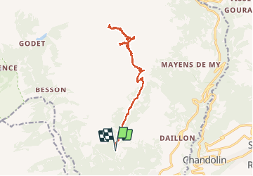
Trail Walking of 15.1 km to be discovered at Valais/Wallis, Conthey, Conthey. This trail is proposed by duamerg.
Description
Prendre la route du col du Sanetsch jusqu'à Daillon. Monter aux Mayens de Conthey jusqu'à Codo et le départ de nombreuses courses. Laisser la voiture. Chemin bien balisé et facile par l'étang de trente pas jusqu'au col de la Croix de la Châ. Retour par le même chemin.
Positioning
Country:
Switzerland
Region :
Valais/Wallis
Department/Province :
Conthey
Municipality :
Conthey
Location:
Unknown
Start:(Dec)
Start:(UTM)
367045 ; 5123507 (32T) N.
Comments
Trails nearby
![Trail On foot Savièse - Bisse de Savièse (Torrent-Neuf) - Photo](https://media.geolcdn.com/t/375/260/2abdaf10-00a9-4b07-a19f-cc4e4efb285c.jpeg&format=jpg&maxdim=2)
![On foot On foot](https://static1.geolcdn.com/sitytour/trail-icons/100.png)
Bisse de Savièse (Torrent-Neuf)
On foot
Easy
Savièse,
Valais/Wallis,
Sion,
Switzerland
![](/images/other/stat-length.png)
4.5 km | 7.4 km-effort
1h 41min
![](https://static1.geolcdn.com/siteimages/upload/files/16400158638029165_repeat_loop_refresh_sync_direction_icon.png)
No
![Trail On foot Ardon - Chemin des berges du Rhône - Photo](https://media.geolcdn.com/t/375/260/134426cf-485a-4873-985c-cf3c80bda5e1.jpeg&format=jpg&maxdim=2)
![On foot On foot](https://static1.geolcdn.com/sitytour/trail-icons/100.png)
Chemin des berges du Rhône
On foot
Easy
Ardon,
Valais/Wallis,
Conthey,
Switzerland
![](/images/other/stat-length.png)
4.4 km | 4.9 km-effort
1h 6min
![](https://static1.geolcdn.com/siteimages/upload/files/16400158638029165_repeat_loop_refresh_sync_direction_icon.png)
No
![Trail On foot Conthey - Bisse de la Tsandra - Photo](https://media.geolcdn.com/t/375/260/1657d19d-aa60-4f9b-8a51-722366c997ed.jpeg&format=jpg&maxdim=2)
![On foot On foot](https://static1.geolcdn.com/sitytour/trail-icons/100.png)
Bisse de la Tsandra
On foot
Easy
Conthey,
Valais/Wallis,
Conthey,
Switzerland
![](/images/other/stat-length.png)
7.4 km | 10.5 km-effort
2h 23min
![](https://static1.geolcdn.com/siteimages/upload/files/16400158638029165_repeat_loop_refresh_sync_direction_icon.png)
No
![Trail Walking Sion - Tour du Massif des Muverans - Photo](https://media.geolcdn.com/t/375/260/ext.jpg?maxdim=2&url=https%3A%2F%2Fservices.sitytrail.com%2FGeolivesWS%2FDownloadMedia.ashx%3FTrailID%3D25683%26Media%3Dimage10.JPG)
![Walking Walking](https://static1.geolcdn.com/sitytour/trail-icons/101.png)
Tour du Massif des Muverans
Walking
Very easy
Sion,
Valais/Wallis,
Sion,
Switzerland
![](/images/other/stat-length.png)
6.2 km | 14.1 km-effort
22h 11min
![](https://static1.geolcdn.com/siteimages/upload/files/16400158638029165_repeat_loop_refresh_sync_direction_icon.png)
No
![Trail Walking Savièse - bises de torrent neuf - Photo](https://media.geolcdn.com/t/375/260/1deb4bd3-f63a-40cf-92d1-fa0b5d331200.jpg&format=jpg&maxdim=2)
![Walking Walking](https://static1.geolcdn.com/sitytour/trail-icons/101.png)
bises de torrent neuf
Walking
Medium
Savièse,
Valais/Wallis,
Sion,
Switzerland
![](/images/other/stat-length.png)
9.9 km | 16 km-effort
4h 12min
![](https://static1.geolcdn.com/siteimages/upload/files/16400158638029165_repeat_loop_refresh_sync_direction_icon.png)
Yes
![Trail Other activity Conthey - st_bg_conthey - Photo](https://media.geolcdn.com/t/375/260/ext.jpg?maxdim=2&url=https%3A%2F%2Fstatic1.geolcdn.com%2Fsiteimages%2Fupload%2Ffiles%2F1545311037marcheuse_200dpi.jpg)
![Other activity Other activity](https://static1.geolcdn.com/sitytour/trail-icons/900.png)
st_bg_conthey
Other activity
Very easy
Conthey,
Valais/Wallis,
Conthey,
Switzerland
![](/images/other/stat-length.png)
22 km | 42 km-effort
9h 21min
![](https://static1.geolcdn.com/siteimages/upload/files/16400158638029165_repeat_loop_refresh_sync_direction_icon.png)
No
![Trail Walking Conthey - huetten_02 - Photo](https://media.geolcdn.com/t/375/260/ext.jpg?maxdim=2&url=https%3A%2F%2Fstatic1.geolcdn.com%2Fsiteimages%2Fupload%2Ffiles%2F1553511878bg_sport_marche.png)
![Walking Walking](https://static1.geolcdn.com/sitytour/trail-icons/101.png)
huetten_02
Walking
Very easy
Conthey,
Valais/Wallis,
Conthey,
Switzerland
![](/images/other/stat-length.png)
50 km | 102 km-effort
16h 52min
![](https://static1.geolcdn.com/siteimages/upload/files/16400158638029165_repeat_loop_refresh_sync_direction_icon.png)
Yes
![Walking Walking](https://static1.geolcdn.com/sitytour/trail-icons/101.png)
Trajet du 29.10.21
Walking
Very difficult
Conthey,
Valais/Wallis,
Conthey,
Switzerland
![](/images/other/stat-length.png)
19.5 km | 38 km-effort
8h 42min
![](https://static1.geolcdn.com/siteimages/upload/files/16400158638029165_repeat_loop_refresh_sync_direction_icon.png)
Yes
![Trail Nordic walking Savièse - bisse torrent neuf - Photo](https://media.geolcdn.com/t/375/260/ext.jpg?maxdim=2&url=https%3A%2F%2Fstatic1.geolcdn.com%2Fsiteimages%2Fupload%2Ffiles%2F1545311037marcheuse_200dpi.jpg)
![Nordic walking Nordic walking](https://static1.geolcdn.com/sitytour/trail-icons/102.png)
bisse torrent neuf
Nordic walking
Easy
Savièse,
Valais/Wallis,
Sion,
Switzerland
![](/images/other/stat-length.png)
9.1 km | 14.2 km-effort
3h 20min
![](https://static1.geolcdn.com/siteimages/upload/files/16400158638029165_repeat_loop_refresh_sync_direction_icon.png)
Yes