![](/images/other/stat-length.png)
![Trail Walking Perros-Guirec - Bretagne - Ploumanac’h-Tregastel par la côte de Granit Rose - Photo](https://media.geolcdn.com/t/1900/400/56e3f6cb-ca77-4783-a40c-d04736abc185.jpg&format=pjpeg&maxdim=2)
Bretagne - Ploumanac’h-Tregastel par la côte de Granit Rose
olive2b
User
![Length](/images/other/stat-length.png)
![Max alt](https://static1.geolcdn.com/siteimages/upload/files/1508320355ic_sort_altitude_max_24dp.png)
![Uphill gradient](https://static1.geolcdn.com/siteimages/upload/files/1508320355ic_sort_den_pos_24dp.png)
![Km-Effort](/images/other/stat-length.png)
![Min alt](https://static1.geolcdn.com/siteimages/upload/files/1508320355ic_sort_altitude_min_24dp.png)
![Downhill gradient](https://static1.geolcdn.com/siteimages/upload/files/1508320355ic_sort_den_neg_24dp.png)
![Boucle](https://static1.geolcdn.com/siteimages/upload/files/16400158638029165_repeat_loop_refresh_sync_direction_icon.png)
![Walking](https://static1.geolcdn.com/sitytour/trail-icons/101.png)
7h04
Difficulty : Easy
![Scan this QR Code to open this trail in the SityTrail application](https://capi.geolives.com/qq0zvz2zws4bq2lad0pu/sitytour/trails/2203705/qr.png?size=200)
FREE GPS app for hiking
About
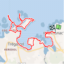
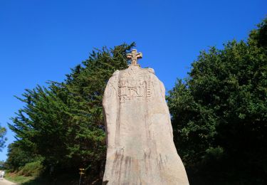
Trail Walking of 17.9 km to be discovered at Brittany, Côtes-d'Armor, Perros-Guirec. This trail is proposed by olive2b.
Description
Départ du parking "granit rose"de Ploumanac'h (côté plage Saint-Guirec).
Attention, cette randonnée s'est faite durant une marée basse.
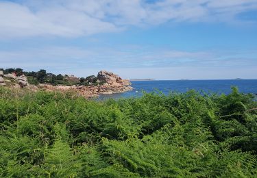
Une superbe balade sur cette belle côte où des amoncellement de rochers aussi beaux les uns que les autres surgissant au détour d'un virage.
Le retour s'es fait par le même chemin.
Ne pas tenir compte du temps, nous avons énormément de pauses photos, contemplations et bien-sur repas.
Positioning
Comments
Trails nearby
![Trail Walking Perros-Guirec - Perros-Guirec - GR34 - 11.1km 185m 2h50 - 2023 09 08 - Photo](https://media.geolcdn.com/t/375/260/d1728063-b6c3-4241-bba7-0eab61cebb20.jpg&format=jpg&maxdim=2)
![Walking Walking](https://static1.geolcdn.com/sitytour/trail-icons/101.png)
Walking
![](/images/other/stat-length.png)
![](https://static1.geolcdn.com/siteimages/upload/files/16400158638029165_repeat_loop_refresh_sync_direction_icon.png)
![Trail Walking Trégastel - Trégastel - GR34 Île Renote Moulin à marée Chapelle de Gorgon - 13.8km 100m 3h35 - 2023 09 07 - Photo](https://media.geolcdn.com/t/375/260/f7b585bc-cd92-4f03-b6f8-635e10f5e6be.jpg&format=jpg&maxdim=2)
![Walking Walking](https://static1.geolcdn.com/sitytour/trail-icons/101.png)
Walking
![](/images/other/stat-length.png)
![](https://static1.geolcdn.com/siteimages/upload/files/16400158638029165_repeat_loop_refresh_sync_direction_icon.png)
![Trail Walking Perros-Guirec - la côte de granit rose à Ploumanach - Photo](https://media.geolcdn.com/t/375/260/64deb34e-d59c-4f9a-95ec-bcb98ff541ad.jpg&format=jpg&maxdim=2)
![Walking Walking](https://static1.geolcdn.com/sitytour/trail-icons/101.png)
Walking
![](/images/other/stat-length.png)
![](https://static1.geolcdn.com/siteimages/upload/files/16400158638029165_repeat_loop_refresh_sync_direction_icon.png)
![Trail Walking Perros-Guirec - Les sentiers de Ploumanac'h - Photo](https://media.geolcdn.com/t/375/260/ext.jpg?maxdim=2&url=https%3A%2F%2Fservices.sitytrail.com%2FGeolivesWS%2FDownloadMedia.ashx%3FTrailID%3D317019%26Media%3D16161_1.jpg)
![Walking Walking](https://static1.geolcdn.com/sitytour/trail-icons/101.png)
Walking
![](/images/other/stat-length.png)
![](https://static1.geolcdn.com/siteimages/upload/files/16400158638029165_repeat_loop_refresh_sync_direction_icon.png)
![Trail Walking Louannec - Louannec - GR34 PR - 11.5km 185m 3h00 (40mn) - 2023 09 14 - Photo](https://media.geolcdn.com/t/375/260/e980ede6-67ca-4aa3-94c9-619423761500.jpg&format=jpg&maxdim=2)
![Walking Walking](https://static1.geolcdn.com/sitytour/trail-icons/101.png)
Walking
![](/images/other/stat-length.png)
![](https://static1.geolcdn.com/siteimages/upload/files/16400158638029165_repeat_loop_refresh_sync_direction_icon.png)
![Trail Walking Trégastel - Trégastel - GR34 Ploumanac'h Kasino de Perros-Guirec - 11.7km 200m 2h55 (50mn) - 2023 09 08 - Photo](https://media.geolcdn.com/t/375/260/3132b43e-4920-4682-bf35-15b1d429cbae.jpg&format=jpg&maxdim=2)
![Walking Walking](https://static1.geolcdn.com/sitytour/trail-icons/101.png)
Walking
![](/images/other/stat-length.png)
![](https://static1.geolcdn.com/siteimages/upload/files/16400158638029165_repeat_loop_refresh_sync_direction_icon.png)
![Trail Walking Pleumeur-Bodou - Pleumeur-Bodou - GR34 Presqu'île de Landrellec - 11km 90m 2h40 (55mn) - 2023 09 07 - Photo](https://media.geolcdn.com/t/375/260/8535d7bc-c32f-4d63-8654-21c356641e89.jpg&format=jpg&maxdim=2)
![Walking Walking](https://static1.geolcdn.com/sitytour/trail-icons/101.png)
Walking
![](/images/other/stat-length.png)
![](https://static1.geolcdn.com/siteimages/upload/files/16400158638029165_repeat_loop_refresh_sync_direction_icon.png)
![Trail Walking Pleumeur-Bodou - Pleumeur-Bodou - GR34 Chapelle Saint-Samson - 7.7km 60m 1h55 - 2023 09 06 - Photo](https://media.geolcdn.com/t/375/260/5d74374c-67e8-400e-845c-98d92708147a.jpg&format=jpg&maxdim=2)
![Walking Walking](https://static1.geolcdn.com/sitytour/trail-icons/101.png)
Walking
![](/images/other/stat-length.png)
![](https://static1.geolcdn.com/siteimages/upload/files/16400158638029165_repeat_loop_refresh_sync_direction_icon.png)
![Trail Walking Pleumeur-Bodou - Pleumeur-Bodou - GR34 Menhir de Saint-Uzec Chapelle de Penvern - 5.6km 60m 1h20 (40mn) - 2023 09 06 - Photo](https://media.geolcdn.com/t/375/260/acb169dc-b395-42f6-b477-bf2c7a0dcada.jpg&format=jpg&maxdim=2)
![Walking Walking](https://static1.geolcdn.com/sitytour/trail-icons/101.png)
Walking
![](/images/other/stat-length.png)
![](https://static1.geolcdn.com/siteimages/upload/files/16400158638029165_repeat_loop_refresh_sync_direction_icon.png)