![](/images/other/stat-length.png)
![Trail Walking Lugano - Mte Bré -Gandria - Lugano - Photo](https://media.geolcdn.com/t/1900/400/ext.pjpeg?maxdim=2&url=https%3A%2F%2Fstatic1.geolcdn.com%2Fsiteimages%2Fupload%2Ffiles%2F1553511878bg_sport_marche.png)
Mte Bré -Gandria - Lugano
duamerg
User
![Length](/images/other/stat-length.png)
Length
7.2 km
![Max alt](https://static1.geolcdn.com/siteimages/upload/files/1508320355ic_sort_altitude_max_24dp.png)
Max alt
923 m
![Uphill gradient](https://static1.geolcdn.com/siteimages/upload/files/1508320355ic_sort_den_pos_24dp.png)
Uphill gradient
108 m
![Km-Effort](/images/other/stat-length.png)
Km-Effort
10.8 km
![Min alt](https://static1.geolcdn.com/siteimages/upload/files/1508320355ic_sort_altitude_min_24dp.png)
Min alt
272 m
![Downhill gradient](https://static1.geolcdn.com/siteimages/upload/files/1508320355ic_sort_den_neg_24dp.png)
Downhill gradient
733 m
![Boucle](https://static1.geolcdn.com/siteimages/upload/files/16400158638029165_repeat_loop_refresh_sync_direction_icon.png)
Boucle
No
Creation date :
2014-12-11 00:00:00.0
Updated on :
2020-01-30 13:58:41.561
![Walking](https://static1.geolcdn.com/sitytour/trail-icons/101.png)
2h05
Difficulty : Easy
![Scan this QR Code to open this trail in the SityTrail application](https://capi.geolives.com/qq0zvz2zws4bq2lad0pu/sitytour/trails/22034/qr.png?size=200)
FREE GPS app for hiking
About
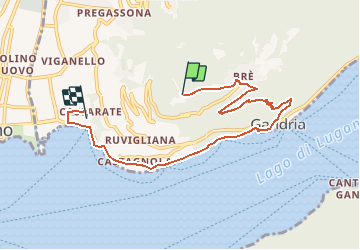
Trail Walking of 7.2 km to be discovered at Ticino, Distretto di Lugano, Lugano. This trail is proposed by duamerg.
Description
prendre le funiculaire pour le Mte Bré. Descendre les marches jusqu'à Bré puis descente jusqu'à Gandria. Suivre le lac puis la route!!! pour rejoindre Lugano.
Positioning
Country:
Switzerland
Region :
Ticino
Department/Province :
Distretto di Lugano
Municipality :
Lugano
Location:
Circolo di Lugano est
Start:(Dec)
Start:(UTM)
498941 ; 5095069 (32T) N.
Comments
Trails nearby
![Trail Walking Lugano - Circuit decouverte Lugano - Photo](https://media.geolcdn.com/t/375/260/6dbbeef0-99d8-4d7f-9738-752dea3e067a.jpg&format=jpg&maxdim=2)
![Walking Walking](https://static1.geolcdn.com/sitytour/trail-icons/101.png)
Circuit decouverte Lugano
Walking
Medium
Lugano,
Ticino,
Distretto di Lugano,
Switzerland
![](/images/other/stat-length.png)
25 km | 40 km-effort
5h 42min
![](https://static1.geolcdn.com/siteimages/upload/files/16400158638029165_repeat_loop_refresh_sync_direction_icon.png)
Yes
![Trail On foot Paradiso - Paradiso-San Salvatore - Photo](https://media.geolcdn.com/t/375/260/fedc3566-7bd8-42a8-a1ce-221aef3a3493.jpeg&format=jpg&maxdim=2)
![On foot On foot](https://static1.geolcdn.com/sitytour/trail-icons/100.png)
Paradiso-San Salvatore
On foot
Easy
Paradiso,
Ticino,
Distretto di Lugano,
Switzerland
![](/images/other/stat-length.png)
3.2 km | 9.1 km-effort
2h 3min
![](https://static1.geolcdn.com/siteimages/upload/files/16400158638029165_repeat_loop_refresh_sync_direction_icon.png)
No
![Trail Other activity Paradiso - y10_hoehenweg_luganersee - Photo](https://media.geolcdn.com/t/375/260/ext.jpg?maxdim=2&url=https%3A%2F%2Fstatic1.geolcdn.com%2Fsiteimages%2Fupload%2Ffiles%2F1545311037marcheuse_200dpi.jpg)
![Other activity Other activity](https://static1.geolcdn.com/sitytour/trail-icons/900.png)
y10_hoehenweg_luganersee
Other activity
Very easy
Paradiso,
Ticino,
Distretto di Lugano,
Switzerland
![](/images/other/stat-length.png)
12.2 km | 22 km-effort
5h 16min
![](https://static1.geolcdn.com/siteimages/upload/files/16400158638029165_repeat_loop_refresh_sync_direction_icon.png)
No
![Trail Other activity Lugano - y10_monte_boglia - Photo](https://media.geolcdn.com/t/375/260/ext.jpg?maxdim=2&url=https%3A%2F%2Fstatic1.geolcdn.com%2Fsiteimages%2Fupload%2Ffiles%2F1545311037marcheuse_200dpi.jpg)
![Other activity Other activity](https://static1.geolcdn.com/sitytour/trail-icons/900.png)
y10_monte_boglia
Other activity
Very easy
Lugano,
Ticino,
Distretto di Lugano,
Switzerland
![](/images/other/stat-length.png)
13.1 km | 32 km-effort
7h 5min
![](https://static1.geolcdn.com/siteimages/upload/files/16400158638029165_repeat_loop_refresh_sync_direction_icon.png)
No
![Trail Mountain bike Lugano - Bike32933 - Photo](https://media.geolcdn.com/t/375/260/ext.jpg?maxdim=2&url=https%3A%2F%2Fstatic1.geolcdn.com%2Fsiteimages%2Fupload%2Ffiles%2F1524743154velo.jpg)
![Mountain bike Mountain bike](https://static1.geolcdn.com/sitytour/trail-icons/202.png)
Bike32933
Mountain bike
Very easy
Lugano,
Ticino,
Distretto di Lugano,
Switzerland
![](/images/other/stat-length.png)
25 km | 38 km-effort
Unknown
![](https://static1.geolcdn.com/siteimages/upload/files/16400158638029165_repeat_loop_refresh_sync_direction_icon.png)
Yes
![Trail Walking Paradiso - Paradiso - San Salvatore - Carona - Morcote - Photo](https://media.geolcdn.com/t/375/260/ext.jpg?maxdim=2&url=https%3A%2F%2Fstatic1.geolcdn.com%2Fsiteimages%2Fupload%2Ffiles%2F1553511878bg_sport_marche.png)
![Walking Walking](https://static1.geolcdn.com/sitytour/trail-icons/101.png)
Paradiso - San Salvatore - Carona - Morcote
Walking
Very easy
Paradiso,
Ticino,
Distretto di Lugano,
Switzerland
![](/images/other/stat-length.png)
11.3 km | 19.9 km-effort
Unknown
![](https://static1.geolcdn.com/siteimages/upload/files/16400158638029165_repeat_loop_refresh_sync_direction_icon.png)
No
![Trail Walking Lugano - YHH131 Lugano - Tesserete - Photo](https://media.geolcdn.com/t/375/260/ext.jpg?maxdim=2&url=https%3A%2F%2Fstatic1.geolcdn.com%2Fsiteimages%2Fupload%2Ffiles%2F1553511878bg_sport_marche.png)
![Walking Walking](https://static1.geolcdn.com/sitytour/trail-icons/101.png)
YHH131 Lugano - Tesserete
Walking
Difficult
Lugano,
Ticino,
Distretto di Lugano,
Switzerland
![](/images/other/stat-length.png)
10.3 km | 15.8 km-effort
3h 52min
![](https://static1.geolcdn.com/siteimages/upload/files/16400158638029165_repeat_loop_refresh_sync_direction_icon.png)
No
![Trail Walking Lugano - S.Salvatore- Morcote - Photo](https://media.geolcdn.com/t/375/260/ext.jpg?maxdim=2&url=https%3A%2F%2Fstatic1.geolcdn.com%2Fsiteimages%2Fupload%2Ffiles%2F1553511878bg_sport_marche.png)
![Walking Walking](https://static1.geolcdn.com/sitytour/trail-icons/101.png)
S.Salvatore- Morcote
Walking
Easy
Lugano,
Ticino,
Distretto di Lugano,
Switzerland
![](/images/other/stat-length.png)
9.4 km | 13.7 km-effort
3h 0min
![](https://static1.geolcdn.com/siteimages/upload/files/16400158638029165_repeat_loop_refresh_sync_direction_icon.png)
No
![Trail Other activity Lugano - TI / brè - monte boglia - alpe bolla - brè - Photo](https://media.geolcdn.com/t/375/260/ext.jpg?maxdim=2&url=https%3A%2F%2Fstatic1.geolcdn.com%2Fsiteimages%2Fupload%2Ffiles%2F1545311037marcheuse_200dpi.jpg)
![Other activity Other activity](https://static1.geolcdn.com/sitytour/trail-icons/900.png)
TI / brè - monte boglia - alpe bolla - brè
Other activity
Very easy
Lugano,
Ticino,
Distretto di Lugano,
Switzerland
![](/images/other/stat-length.png)
11.9 km | 22 km-effort
Unknown
![](https://static1.geolcdn.com/siteimages/upload/files/16400158638029165_repeat_loop_refresh_sync_direction_icon.png)
Yes