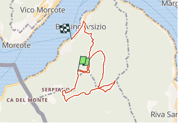
![](/images/other/stat-length.png)
![Trail Walking Brusino Arsizio - M. S, Giorgio - Photo](https://media.geolcdn.com/t/1900/400/ext.pjpeg?maxdim=2&url=https%3A%2F%2Fstatic1.geolcdn.com%2Fsiteimages%2Fupload%2Ffiles%2F1553511878bg_sport_marche.png)
M. S, Giorgio
duamerg
User
![Length](/images/other/stat-length.png)
![Max alt](https://static1.geolcdn.com/siteimages/upload/files/1508320355ic_sort_altitude_max_24dp.png)
![Uphill gradient](https://static1.geolcdn.com/siteimages/upload/files/1508320355ic_sort_den_pos_24dp.png)
![Km-Effort](/images/other/stat-length.png)
![Min alt](https://static1.geolcdn.com/siteimages/upload/files/1508320355ic_sort_altitude_min_24dp.png)
![Downhill gradient](https://static1.geolcdn.com/siteimages/upload/files/1508320355ic_sort_den_neg_24dp.png)
![Boucle](https://static1.geolcdn.com/siteimages/upload/files/16400158638029165_repeat_loop_refresh_sync_direction_icon.png)
![Walking](https://static1.geolcdn.com/sitytour/trail-icons/101.png)
3h30
Difficulty : Medium
![Scan this QR Code to open this trail in the SityTrail application](https://capi.geolives.com/qq0zvz2zws4bq2lad0pu/sitytour/trails/22031/qr.png?size=200)
FREE GPS app for hiking
About
Trail Walking of 8.2 km to be discovered at Ticino, Distretto di Lugano, Brusino Arsizio. This trail is proposed by duamerg.
Description
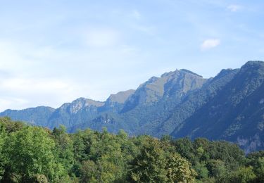
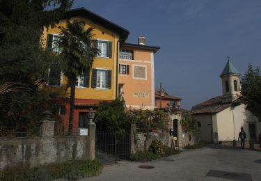
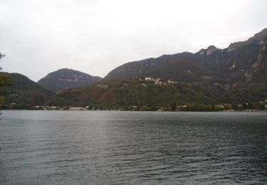
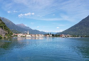
Prendre le téléphérique à Brusino, départ toutes les demi-heures.Suivre le sentier pour le Grotto de l'Alpe de Brusino. Depuis là, forte montée jusqu'au Mont S. Giorgio. Revenir sur ses pas et suivre les panneaux Serpiano. Forte descente avec belle vue sur Morcotte. De Serpiano rejoindre le téléphérique (restaurant avec vue). Descendre au village. Chemins en général glissants sur les cailloux ou la terre sabloneuse. Bonnes chaussures.
Positioning
Comments
Trails nearby
![Trail On foot Porto Ceresio - Via Verde Varesina tappa 1 - Photo](https://media.geolcdn.com/t/375/260/e9575b87-6844-4d44-b855-68e97d696f12.jpeg&format=jpg&maxdim=2)
![On foot On foot](https://static1.geolcdn.com/sitytour/trail-icons/100.png)
On foot
![](/images/other/stat-length.png)
![](https://static1.geolcdn.com/siteimages/upload/files/16400158638029165_repeat_loop_refresh_sync_direction_icon.png)
![Trail On foot Porto Ceresio - (SI D07) Porto Ceresio - Viggiù - Photo](https://media.geolcdn.com/t/375/260/ec40e8c4-aaa2-4dd6-b1eb-f245da5a46e5.jpeg&format=jpg&maxdim=2)
![On foot On foot](https://static1.geolcdn.com/sitytour/trail-icons/100.png)
On foot
![](/images/other/stat-length.png)
![](https://static1.geolcdn.com/siteimages/upload/files/16400158638029165_repeat_loop_refresh_sync_direction_icon.png)
![Trail On foot Mendrisio - Itinerario](https://media.geolcdn.com/t/375/260/4a141307-4c40-4996-9897-8c55b55a38a6.jpeg&format=jpg&maxdim=2)
![On foot On foot](https://static1.geolcdn.com/sitytour/trail-icons/100.png)
On foot
![](/images/other/stat-length.png)
![](https://static1.geolcdn.com/siteimages/upload/files/16400158638029165_repeat_loop_refresh_sync_direction_icon.png)
![Trail On foot Melide - Melide-Vico Morcote - Photo](https://media.geolcdn.com/t/375/260/aa751a24-7b34-4794-903f-71b2aa17915a.jpeg&format=jpg&maxdim=2)
![On foot On foot](https://static1.geolcdn.com/sitytour/trail-icons/100.png)
On foot
![](/images/other/stat-length.png)
![](https://static1.geolcdn.com/siteimages/upload/files/16400158638029165_repeat_loop_refresh_sync_direction_icon.png)
![Trail On foot Mendrisio - Meride-Mendrisio Stazione - Photo](https://media.geolcdn.com/t/375/260/dbfb3492-361f-49ef-912a-3dc2d1cf9cda.jpeg&format=jpg&maxdim=2)
![On foot On foot](https://static1.geolcdn.com/sitytour/trail-icons/100.png)
On foot
![](/images/other/stat-length.png)
![](https://static1.geolcdn.com/siteimages/upload/files/16400158638029165_repeat_loop_refresh_sync_direction_icon.png)
![Trail On foot Lugano - Carona-Alpe Vicania - Photo](https://media.geolcdn.com/t/375/260/80e04e5d-c3ad-4349-81fa-18933541e228.jpeg&format=jpg&maxdim=2)
![On foot On foot](https://static1.geolcdn.com/sitytour/trail-icons/100.png)
On foot
![](/images/other/stat-length.png)
![](https://static1.geolcdn.com/siteimages/upload/files/16400158638029165_repeat_loop_refresh_sync_direction_icon.png)
![Trail On foot Melano - Maroggia - Bissone - Photo](https://media.geolcdn.com/t/375/260/6ea1aab7-8066-4101-bf93-9bc5e27b1b49.jpeg&format=jpg&maxdim=2)
![On foot On foot](https://static1.geolcdn.com/sitytour/trail-icons/100.png)
On foot
![](/images/other/stat-length.png)
![](https://static1.geolcdn.com/siteimages/upload/files/16400158638029165_repeat_loop_refresh_sync_direction_icon.png)
![Trail Cycle Brusimpiano - venetië dag 19 - Photo](https://media.geolcdn.com/t/375/260/ext.jpg?maxdim=2&url=https%3A%2F%2Fservices.sitytrail.com%2FGeolivesWS%2FDownloadMedia.ashx%3FTrailID%3D774049%26Media%3Dfix__20170616144708.jpg)
![Cycle Cycle](https://static1.geolcdn.com/sitytour/trail-icons/200.png)
![Trail Walking Mendrisio - hike31 - Photo](https://media.geolcdn.com/t/375/260/ext.jpg?maxdim=2&url=https%3A%2F%2Fstatic1.geolcdn.com%2Fsiteimages%2Fupload%2Ffiles%2F1553511878bg_sport_marche.png)
![Walking Walking](https://static1.geolcdn.com/sitytour/trail-icons/101.png)
Walking
![](/images/other/stat-length.png)
![](https://static1.geolcdn.com/siteimages/upload/files/16400158638029165_repeat_loop_refresh_sync_direction_icon.png)