oulanpekin SityTrail > Trails > Outdoor > Unknown > Unknown > Unknown > Unknown SityTrail > Trails > Outdoor > Unknown > Unknown > Unknown > Unknown oulanpekin DUPORT16 User 3D © OpenStreetMap contributors Length 1348 km Boucle No Creation date : 2019-09-12 10:12:28.245 Updated on : 2019-09-12 16:43:35.448 (0 Reviews) Plane 2h17 Difficulty : Very easy FREE GPS app for hiking SityTrail IGN / Geographical institutes SityTrail World The world is yours! About Trail Plane of 1348 km to be discovered at . This trail is proposed by DUPORT16. Legends | More details (PDF) Elevation profile Legends > 15% 15% - 10% 10% - 5% flat 5% - 10% 10% - 15% 15% - 30% > 30% Positioning Country: Unknown Region : Unknown Department/Province : Unknown Municipality : Unknown Location: Unknown Start:(Dec) 47.85217144221935 / 106.7599340368544 Start:(UTM) 631656 ; 5301369 (48T) N. Comments Please log in to post a review or rate the element Trails nearby DUPORT16 Mongolie111 Car Very easy , , , 
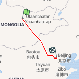
91 km | 107 km-effort 3h 18min No