![Trail Car Hongorïn Els - Mongolie10 - Photo](https://media.geolcdn.com/t/1900/400/e800fbb2-665a-4dce-9323-d68da1204308.jpg&format=pjpeg&maxdim=2)
Mongolie10
DUPORT16
User
![Length](/images/other/stat-length.png)
Length
234 km
![Max alt](https://static1.geolcdn.com/siteimages/upload/files/1508320355ic_sort_altitude_max_24dp.png)
Max alt
2419 m
![Uphill gradient](https://static1.geolcdn.com/siteimages/upload/files/1508320355ic_sort_den_pos_24dp.png)
Uphill gradient
2667 m
![Km-Effort](/images/other/stat-length.png)
Km-Effort
269 km
![Min alt](https://static1.geolcdn.com/siteimages/upload/files/1508320355ic_sort_altitude_min_24dp.png)
Min alt
1427 m
![Downhill gradient](https://static1.geolcdn.com/siteimages/upload/files/1508320355ic_sort_den_neg_24dp.png)
Downhill gradient
2509 m
![Boucle](https://static1.geolcdn.com/siteimages/upload/files/16400158638029165_repeat_loop_refresh_sync_direction_icon.png)
Boucle
No
Creation date :
2019-09-10 01:08:34.783
Updated on :
2019-09-11 04:53:38.04
![Car](https://static1.geolcdn.com/sitytour/trail-icons/401.png)
9h44
Difficulty : Very easy
![Scan this QR Code to open this trail in the SityTrail application](https://capi.geolives.com/qq0zvz2zws4bq2lad0pu/sitytour/trails/2198127/qr.png?size=200)
FREE GPS app for hiking
About
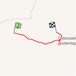
Trail Car of 234 km to be discovered at Ömnögovi, Sevrei. This trail is proposed by DUPORT16.
Positioning
Country:
Mongolia
Region :
Ömnögovi
Department/Province :
Sevrei
Municipality :
Hongorïn Els
Location:
Unknown
Start:(Dec)
Start:(UTM)
285822 ; 4852159 (48T) N.
Comments
Trails nearby