Dompierre; trace GPS du 10/09/2019
toporient
User
Length
8.2 km
Max alt
246 m
Uphill gradient
145 m
Km-Effort
10.2 km
Min alt
188 m
Downhill gradient
145 m
Boucle
Yes
Creation date :
2019-09-10 11:24:37.262
Updated on :
2019-09-11 16:14:37.524
4h30
Difficulty : Very easy
FREE GPS app for hiking
About
Trail Walking of 8.2 km to be discovered at Normandy, Orne, Dompierre. This trail is proposed by toporient.
Description
Boucle en 8 en terrain varié où alternent lignes de crête, chemins creux et une piste empierrée.
Départ du parking sortie ouest de Dompierre sur la D21 (route de Domfront).
Positioning
Country:
France
Region :
Normandy
Department/Province :
Orne
Municipality :
Dompierre
Location:
Unknown
Start:(Dec)
Start:(UTM)
680240 ; 5389450 (30U) N.
Comments
Trails nearby
Circuit of IRON by Yannick-p14-61
Walking
Medium
(1)
La Ferrière-aux-Étangs,
Normandy,
Orne,
France
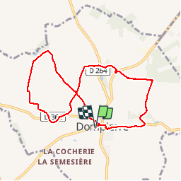
13.3 km | 16.5 km-effort
3h 35min
Yes
La Ferrière - La Ferrière aux Etangs
Walking
Medium
La Ferrière-aux-Étangs,
Normandy,
Orne,
France
14.3 km | 17.9 km-effort
3h 4min
Yes
Espace VTT FFC les Ecureuils du Domfrontais - Circuit n°14 - Champsecret
Mountain bike
Medium
,
Normandy,
Orne,
France
22 km | 26 km-effort
2h 0min
Yes
1h16
Walking
Medium
La Ferrière-aux-Étangs,
Normandy,
Orne,
France
6.4 km | 8.5 km-effort
1h 16min
Yes
La Feriere aux etant
Walking
Very easy
La Ferrière-aux-Étangs,
Normandy,
Orne,
France
1.2 km | 1.3 km-effort
36min
Yes
Dompierre longue
Walking
Medium
Dompierre,
Normandy,
Orne,
France
8.3 km | 10 km-effort
2h 13min
Yes
Ermitage-Roches aux Dames et aux loups
Walking
Medium
Champsecret,
Normandy,
Orne,
France
9 km | 11 km-effort
2h 23min
Yes