![](/images/other/stat-length.png)
![Trail Winter sports Montricher - Mt-Tendre - Photo](https://media.geolcdn.com/t/1900/400/ext.pjpeg?maxdim=2&url=https%3A%2F%2Fstatic1.geolcdn.com%2Fsiteimages%2Fupload%2Ffiles%2F1524743153ski.jpg)
Mt-Tendre
tigrouu
User
![Length](/images/other/stat-length.png)
Length
5.1 km
![Max alt](https://static1.geolcdn.com/siteimages/upload/files/1508320355ic_sort_altitude_max_24dp.png)
Max alt
1659 m
![Uphill gradient](https://static1.geolcdn.com/siteimages/upload/files/1508320355ic_sort_den_pos_24dp.png)
Uphill gradient
746 m
![Km-Effort](/images/other/stat-length.png)
Km-Effort
12.6 km
![Min alt](https://static1.geolcdn.com/siteimages/upload/files/1508320355ic_sort_altitude_min_24dp.png)
Min alt
906 m
![Downhill gradient](https://static1.geolcdn.com/siteimages/upload/files/1508320355ic_sort_den_neg_24dp.png)
Downhill gradient
0 m
![Boucle](https://static1.geolcdn.com/siteimages/upload/files/16400158638029165_repeat_loop_refresh_sync_direction_icon.png)
Boucle
No
Creation date :
2014-12-11 00:00:00.0
Updated on :
2014-12-11 00:00:00.0
![Winter sports](https://static1.geolcdn.com/sitytour/trail-icons/500.png)
--
Difficulty : Unknown
![Scan this QR Code to open this trail in the SityTrail application](https://capi.geolives.com/qq0zvz2zws4bq2lad0pu/sitytour/trails/21954/qr.png?size=200)
FREE GPS app for hiking
About
Trail Winter sports of 5.1 km to be discovered at Vaud, District de Morges, Montricher. This trail is proposed by tigrouu.
Description
Montée et descente par le chemin romain en ski, à faire dans de bonne condition de neige. Départ depuis les hauts de Montricher.
La descente est technique. Peu de place pour tourner, slalom entre les arbres par endroit.
Positioning
Country:
Switzerland
Region :
Vaud
Department/Province :
District de Morges
Municipality :
Montricher
Location:
Unknown
Start:(Dec)
Start:(UTM)
297934 ; 5163919 (32T) N.
Comments
Trails nearby
![Trail Walking Mont-la-Ville - Jura Club Grand Tour belle vue lac leman - Photo](https://media.geolcdn.com/t/375/260/ef457377-2225-4112-a04a-847f4d6a388b.jpg&format=jpg&maxdim=2)
![Walking Walking](https://static1.geolcdn.com/sitytour/trail-icons/101.png)
Jura Club Grand Tour belle vue lac leman
Walking
Easy
Mont-la-Ville,
Vaud,
District de Morges,
Switzerland
![](/images/other/stat-length.png)
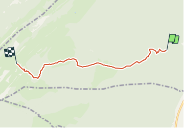
3.4 km | 4.8 km-effort
1h 6min
![](https://static1.geolcdn.com/siteimages/upload/files/16400158638029165_repeat_loop_refresh_sync_direction_icon.png)
Yes
![Trail Mountain bike Montricher - Montricher PréMollens - Photo](https://media.geolcdn.com/t/375/260/faa157aa-2102-483c-b370-b06140b2fff7.jpg&format=jpg&maxdim=2)
![Mountain bike Mountain bike](https://static1.geolcdn.com/sitytour/trail-icons/202.png)
Montricher PréMollens
Mountain bike
Very easy
Montricher,
Vaud,
District de Morges,
Switzerland
![](/images/other/stat-length.png)
36 km | 51 km-effort
2h 25min
![](https://static1.geolcdn.com/siteimages/upload/files/16400158638029165_repeat_loop_refresh_sync_direction_icon.png)
Yes
![Trail Equestrian Cuarnens - Le Creux et le Lac - Photo](https://media.geolcdn.com/t/375/260/ext.jpg?maxdim=2&url=https%3A%2F%2Fstatic1.geolcdn.com%2Fsiteimages%2Fupload%2Ffiles%2F1524743154cheval.jpg)
![Equestrian Equestrian](https://static1.geolcdn.com/sitytour/trail-icons/300.png)
Le Creux et le Lac
Equestrian
Very easy
(1)
Cuarnens,
Vaud,
District de Morges,
Switzerland
![](/images/other/stat-length.png)
18.4 km | 28 km-effort
3h 42min
![](https://static1.geolcdn.com/siteimages/upload/files/16400158638029165_repeat_loop_refresh_sync_direction_icon.png)
No
![Trail Other activity L'Isle - L''Isle - Mont-la-Ville - Cromlech - Pierre Pouilleuse - L''Isle - Photo](https://media.geolcdn.com/t/375/260/ext.jpg?maxdim=2&url=https%3A%2F%2Fstatic1.geolcdn.com%2Fsiteimages%2Fupload%2Ffiles%2F1545311037marcheuse_200dpi.jpg)
![Other activity Other activity](https://static1.geolcdn.com/sitytour/trail-icons/900.png)
L''Isle - Mont-la-Ville - Cromlech - Pierre Pouilleuse - L''Isle
Other activity
Very easy
L'Isle,
Vaud,
District de Morges,
Switzerland
![](/images/other/stat-length.png)
13.3 km | 16.5 km-effort
Unknown
![](https://static1.geolcdn.com/siteimages/upload/files/16400158638029165_repeat_loop_refresh_sync_direction_icon.png)
Yes
![Trail Snowshoes Montricher - Montricher_Mont Tendre - Photo](https://media.geolcdn.com/t/375/260/ext.jpg?maxdim=2&url=https%3A%2F%2Fstatic1.geolcdn.com%2Fsiteimages%2Fupload%2Ffiles%2F1524743153raquette.jpg)
![Snowshoes Snowshoes](https://static1.geolcdn.com/sitytour/trail-icons/504.png)
Montricher_Mont Tendre
Snowshoes
Very easy
Montricher,
Vaud,
District de Morges,
Switzerland
![](/images/other/stat-length.png)
9.7 km | 18.7 km-effort
3h 28min
![](https://static1.geolcdn.com/siteimages/upload/files/16400158638029165_repeat_loop_refresh_sync_direction_icon.png)
No
![Trail Other activity Montricher - Montricher_Châtel - Photo](https://media.geolcdn.com/t/375/260/ext.jpg?maxdim=2&url=https%3A%2F%2Fstatic1.geolcdn.com%2Fsiteimages%2Fupload%2Ffiles%2F1545311037marcheuse_200dpi.jpg)
![Other activity Other activity](https://static1.geolcdn.com/sitytour/trail-icons/900.png)
Montricher_Châtel
Other activity
Very easy
Montricher,
Vaud,
District de Morges,
Switzerland
![](/images/other/stat-length.png)
3.3 km | 9.6 km-effort
Unknown
![](https://static1.geolcdn.com/siteimages/upload/files/16400158638029165_repeat_loop_refresh_sync_direction_icon.png)
No
![Trail Winter sports Montricher - Mont-Tendre - Entre Léman et Vallée de Joux - Photo](https://media.geolcdn.com/t/375/260/ext.jpg?maxdim=2&url=https%3A%2F%2Fstatic1.geolcdn.com%2Fsiteimages%2Fupload%2Ffiles%2F1524743153ski.jpg)
![Winter sports Winter sports](https://static1.geolcdn.com/sitytour/trail-icons/500.png)
Mont-Tendre - Entre Léman et Vallée de Joux
Winter sports
Very easy
Montricher,
Vaud,
District de Morges,
Switzerland
![](/images/other/stat-length.png)
28 km | 43 km-effort
Unknown
![](https://static1.geolcdn.com/siteimages/upload/files/16400158638029165_repeat_loop_refresh_sync_direction_icon.png)
Yes
![Trail Walking L'Isle - l'isle met eline - Photo](https://media.geolcdn.com/t/375/260/ext.jpg?maxdim=2&url=https%3A%2F%2Fstatic1.geolcdn.com%2Fsiteimages%2Fupload%2Ffiles%2F1553511878bg_sport_marche.png)
![Walking Walking](https://static1.geolcdn.com/sitytour/trail-icons/101.png)
l'isle met eline
Walking
Medium
L'Isle,
Vaud,
District de Morges,
Switzerland
![](/images/other/stat-length.png)
13 km | 19 km-effort
3h 50min
![](https://static1.geolcdn.com/siteimages/upload/files/16400158638029165_repeat_loop_refresh_sync_direction_icon.png)
No
![Trail Walking L'Isle - isle met pijo - Photo](https://media.geolcdn.com/t/375/260/ext.jpg?maxdim=2&url=https%3A%2F%2Fstatic1.geolcdn.com%2Fsiteimages%2Fupload%2Ffiles%2F1553511878bg_sport_marche.png)
![Walking Walking](https://static1.geolcdn.com/sitytour/trail-icons/101.png)
isle met pijo
Walking
Very easy
L'Isle,
Vaud,
District de Morges,
Switzerland
![](/images/other/stat-length.png)
5.6 km | 6.8 km-effort
1h 37min
![](https://static1.geolcdn.com/siteimages/upload/files/16400158638029165_repeat_loop_refresh_sync_direction_icon.png)
No