![](/images/other/stat-length.png)
![Trail Mountain bike Aubonne - Le Molard par les vignobles - Photo](https://media.geolcdn.com/t/1900/400/ext.pjpeg?maxdim=2&url=https%3A%2F%2Fstatic1.geolcdn.com%2Fsiteimages%2Fupload%2Ffiles%2F1524743154velo.jpg)
Le Molard par les vignobles
tigrouu
User
![Length](/images/other/stat-length.png)
Length
32 km
![Max alt](https://static1.geolcdn.com/siteimages/upload/files/1508320355ic_sort_altitude_max_24dp.png)
Max alt
886 m
![Uphill gradient](https://static1.geolcdn.com/siteimages/upload/files/1508320355ic_sort_den_pos_24dp.png)
Uphill gradient
835 m
![Km-Effort](/images/other/stat-length.png)
Km-Effort
43 km
![Min alt](https://static1.geolcdn.com/siteimages/upload/files/1508320355ic_sort_altitude_min_24dp.png)
Min alt
468 m
![Downhill gradient](https://static1.geolcdn.com/siteimages/upload/files/1508320355ic_sort_den_neg_24dp.png)
Downhill gradient
845 m
![Boucle](https://static1.geolcdn.com/siteimages/upload/files/16400158638029165_repeat_loop_refresh_sync_direction_icon.png)
Boucle
Yes
Creation date :
2014-12-11 00:00:00.0
Updated on :
2014-12-11 00:00:00.0
![Mountain bike](https://static1.geolcdn.com/sitytour/trail-icons/202.png)
--
Difficulty : Unknown
![Scan this QR Code to open this trail in the SityTrail application](https://capi.geolives.com/qq0zvz2zws4bq2lad0pu/sitytour/trails/21953/qr.png?size=200)
FREE GPS app for hiking
About
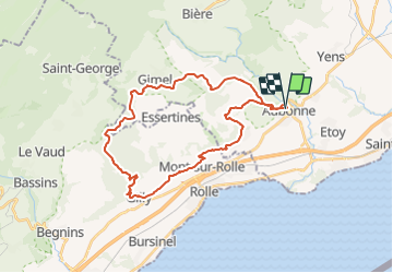
Trail Mountain bike of 32 km to be discovered at Vaud, District de Morges, Aubonne. This trail is proposed by tigrouu.
Description
Parcours se déroulant principalement sur route goudronée ( 70 magnifique vue depuis le vignoble de la Côte sur le bassin lémanique et sur les Alpes.
Route à trés faible densité de trafic.
Positioning
Country:
Switzerland
Region :
Vaud
Department/Province :
District de Morges
Municipality :
Aubonne
Location:
Aubonne
Start:(Dec)
Start:(UTM)
299655 ; 5152471 (32T) N.
Comments
Trails nearby
![Trail Mountain bike Aubonne - Aubonne-Cunay-Montricher-Aubonne - Photo](https://media.geolcdn.com/t/375/260/ext.jpg?maxdim=2&url=https%3A%2F%2Fstatic1.geolcdn.com%2Fsiteimages%2Fupload%2Ffiles%2F1524743154velo.jpg)
![Mountain bike Mountain bike](https://static1.geolcdn.com/sitytour/trail-icons/202.png)
Aubonne-Cunay-Montricher-Aubonne
Mountain bike
Very easy
(1)
Aubonne,
Vaud,
District de Morges,
Switzerland
![](/images/other/stat-length.png)
53 km | 73 km-effort
3h 40min
![](https://static1.geolcdn.com/siteimages/upload/files/16400158638029165_repeat_loop_refresh_sync_direction_icon.png)
Yes
![Trail Walking Aubonne - Vallon de l'Aubonne - Photo](https://media.geolcdn.com/t/375/260/ext.jpg?maxdim=2&url=https%3A%2F%2Fstatic1.geolcdn.com%2Fsiteimages%2Fupload%2Ffiles%2F1553511878bg_sport_marche.png)
![Walking Walking](https://static1.geolcdn.com/sitytour/trail-icons/101.png)
Vallon de l'Aubonne
Walking
Easy
Aubonne,
Vaud,
District de Morges,
Switzerland
![](/images/other/stat-length.png)
11.3 km | 15.3 km-effort
4h 15min
![](https://static1.geolcdn.com/siteimages/upload/files/16400158638029165_repeat_loop_refresh_sync_direction_icon.png)
Yes
![Trail Walking Rolle - Via Jacobi, Rolle - Nyon - Photo](https://media.geolcdn.com/t/375/260/ext.jpg?maxdim=2&url=https%3A%2F%2Fstatic1.geolcdn.com%2Fsiteimages%2Fupload%2Ffiles%2F1553511878bg_sport_marche.png)
![Walking Walking](https://static1.geolcdn.com/sitytour/trail-icons/101.png)
Via Jacobi, Rolle - Nyon
Walking
Easy
Rolle,
Vaud,
District de Nyon,
Switzerland
![](/images/other/stat-length.png)
16.3 km | 18.5 km-effort
4h 14min
![](https://static1.geolcdn.com/siteimages/upload/files/16400158638029165_repeat_loop_refresh_sync_direction_icon.png)
No
![Trail Other activity Aubonne - aubonne - Photo](https://media.geolcdn.com/t/375/260/ext.jpg?maxdim=2&url=https%3A%2F%2Fstatic1.geolcdn.com%2Fsiteimages%2Fupload%2Ffiles%2F1545311037marcheuse_200dpi.jpg)
![Other activity Other activity](https://static1.geolcdn.com/sitytour/trail-icons/900.png)
aubonne
Other activity
Very easy
Aubonne,
Vaud,
District de Morges,
Switzerland
![](/images/other/stat-length.png)
4.5 km | 6.5 km-effort
Unknown
![](https://static1.geolcdn.com/siteimages/upload/files/16400158638029165_repeat_loop_refresh_sync_direction_icon.png)
No
![Trail Other activity Rolle - Signal de Bougy - Photo](https://media.geolcdn.com/t/375/260/ext.jpg?maxdim=2&url=https%3A%2F%2Fstatic1.geolcdn.com%2Fsiteimages%2Fupload%2Ffiles%2F1545311037marcheuse_200dpi.jpg)
![Other activity Other activity](https://static1.geolcdn.com/sitytour/trail-icons/900.png)
Signal de Bougy
Other activity
Very easy
Rolle,
Vaud,
District de Nyon,
Switzerland
![](/images/other/stat-length.png)
10.7 km | 15.8 km-effort
Unknown
![](https://static1.geolcdn.com/siteimages/upload/files/16400158638029165_repeat_loop_refresh_sync_direction_icon.png)
Yes
![Trail Other activity Rolle - Rolle - Photo](https://media.geolcdn.com/t/375/260/ext.jpg?maxdim=2&url=https%3A%2F%2Fstatic1.geolcdn.com%2Fsiteimages%2Fupload%2Ffiles%2F1545311037marcheuse_200dpi.jpg)
![Other activity Other activity](https://static1.geolcdn.com/sitytour/trail-icons/900.png)
Rolle
Other activity
Very easy
Rolle,
Vaud,
District de Nyon,
Switzerland
![](/images/other/stat-length.png)
6.1 km | 7 km-effort
Unknown
![](https://static1.geolcdn.com/siteimages/upload/files/16400158638029165_repeat_loop_refresh_sync_direction_icon.png)
Yes
![Trail Other activity Aubonne - 19-Aubonne - Nyon - Photo](https://media.geolcdn.com/t/375/260/ext.jpg?maxdim=2&url=https%3A%2F%2Fstatic1.geolcdn.com%2Fsiteimages%2Fupload%2Ffiles%2F1545311037marcheuse_200dpi.jpg)
![Other activity Other activity](https://static1.geolcdn.com/sitytour/trail-icons/900.png)
19-Aubonne - Nyon
Other activity
Very easy
Aubonne,
Vaud,
District de Morges,
Switzerland
![](/images/other/stat-length.png)
22 km | 25 km-effort
5h 20min
![](https://static1.geolcdn.com/siteimages/upload/files/16400158638029165_repeat_loop_refresh_sync_direction_icon.png)
No
![Trail Mountain bike Bière - Course Bike-bière 27 Km - Photo](https://media.geolcdn.com/t/375/260/ext.jpg?maxdim=2&url=https%3A%2F%2Fstatic1.geolcdn.com%2Fsiteimages%2Fupload%2Ffiles%2F1524743154velo.jpg)
![Mountain bike Mountain bike](https://static1.geolcdn.com/sitytour/trail-icons/202.png)
Course Bike-bière 27 Km
Mountain bike
Very easy
Bière,
Vaud,
District de Morges,
Switzerland
![](/images/other/stat-length.png)
8.6 km | 10.9 km-effort
Unknown
![](https://static1.geolcdn.com/siteimages/upload/files/16400158638029165_repeat_loop_refresh_sync_direction_icon.png)
Yes
![Trail Mountain bike Bière - Course Bière-Bike 30 Km - Photo](https://media.geolcdn.com/t/375/260/ext.jpg?maxdim=2&url=https%3A%2F%2Fstatic1.geolcdn.com%2Fsiteimages%2Fupload%2Ffiles%2F1524743154velo.jpg)
![Mountain bike Mountain bike](https://static1.geolcdn.com/sitytour/trail-icons/202.png)
Course Bière-Bike 30 Km
Mountain bike
Very easy
Bière,
Vaud,
District de Morges,
Switzerland
![](/images/other/stat-length.png)
10.1 km | 12.7 km-effort
Unknown
![](https://static1.geolcdn.com/siteimages/upload/files/16400158638029165_repeat_loop_refresh_sync_direction_icon.png)
Yes