![Trail Car Burgaasatayn Hiid - Mongolie72 - Photo](https://media.geolcdn.com/t/1900/400/ext.pjpeg?maxdim=2&url=https%3A%2F%2Fstatic1.geolcdn.com%2Fsiteimages%2Fupload%2Ffiles%2F15247431544x4.jpg)
Mongolie72
DUPORT16
User
![Length](/images/other/stat-length.png)
Length
47 km
![Max alt](https://static1.geolcdn.com/siteimages/upload/files/1508320355ic_sort_altitude_max_24dp.png)
Max alt
1834 m
![Uphill gradient](https://static1.geolcdn.com/siteimages/upload/files/1508320355ic_sort_den_pos_24dp.png)
Uphill gradient
340 m
![Km-Effort](/images/other/stat-length.png)
Km-Effort
52 km
![Min alt](https://static1.geolcdn.com/siteimages/upload/files/1508320355ic_sort_altitude_min_24dp.png)
Min alt
1611 m
![Downhill gradient](https://static1.geolcdn.com/siteimages/upload/files/1508320355ic_sort_den_neg_24dp.png)
Downhill gradient
555 m
![Boucle](https://static1.geolcdn.com/siteimages/upload/files/16400158638029165_repeat_loop_refresh_sync_direction_icon.png)
Boucle
No
Creation date :
2019-09-07 06:53:36.19
Updated on :
2019-09-08 12:27:22.391
![Car](https://static1.geolcdn.com/sitytour/trail-icons/401.png)
2h27
Difficulty : Very easy
![Scan this QR Code to open this trail in the SityTrail application](https://capi.geolives.com/qq0zvz2zws4bq2lad0pu/sitytour/trails/2195140/qr.png?size=200)
FREE GPS app for hiking
About
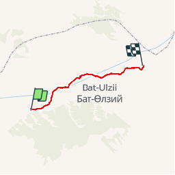
Trail Car of 47 km to be discovered at Övörkhangai, Bat-Olzii. This trail is proposed by DUPORT16.
Positioning
Country:
Mongolia
Region :
Övörkhangai
Department/Province :
Bat-Olzii
Municipality :
Burgaasatayn Hiid
Location:
Unknown
Start:(Dec)
Start:(UTM)
726179 ; 5184552 (47T) N.
Comments
Trails nearby