![](/images/other/stat-length.png)
![Trail Walking Montreal - Trail Planner Map - Photo](https://media.geolcdn.com/t/1900/400/ext.pjpeg?maxdim=2&url=https%3A%2F%2Fstatic1.geolcdn.com%2Fsiteimages%2Fupload%2Ffiles%2F1553511878bg_sport_marche.png)
Trail Planner Map
Alizée.pee
User GUIDE
![Length](/images/other/stat-length.png)
Length
9.9 km
![Max alt](https://static1.geolcdn.com/siteimages/upload/files/1508320355ic_sort_altitude_max_24dp.png)
Max alt
46 m
![Uphill gradient](https://static1.geolcdn.com/siteimages/upload/files/1508320355ic_sort_den_pos_24dp.png)
Uphill gradient
110 m
![Km-Effort](/images/other/stat-length.png)
Km-Effort
11.3 km
![Min alt](https://static1.geolcdn.com/siteimages/upload/files/1508320355ic_sort_altitude_min_24dp.png)
Min alt
21 m
![Downhill gradient](https://static1.geolcdn.com/siteimages/upload/files/1508320355ic_sort_den_neg_24dp.png)
Downhill gradient
110 m
![Boucle](https://static1.geolcdn.com/siteimages/upload/files/16400158638029165_repeat_loop_refresh_sync_direction_icon.png)
Boucle
Yes
Creation date :
2019-09-06 14:19:18.418
Updated on :
2019-09-06 14:24:42.978
![Walking](https://static1.geolcdn.com/sitytour/trail-icons/101.png)
2h29
Difficulty : Medium
![Scan this QR Code to open this trail in the SityTrail application](https://capi.geolives.com/qq0zvz2zws4bq2lad0pu/sitytour/trails/2193453/qr.png?size=200)
FREE GPS app for hiking
About
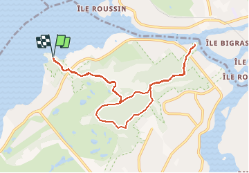
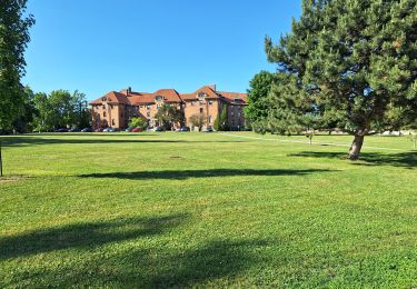
Trail Walking of 9.9 km to be discovered at Quebec, Urban agglomeration of Montreal, Montreal. This trail is proposed by Alizée.pee.
Description
Sentier se trouvant près de Montréal, qui comprend un lac. La randonnée propose de magnifiques vues sur le lac et elle est très agréable ! Je vous la recommande vivement.
Positioning
Country:
Canada
Region :
Quebec
Department/Province :
Urban agglomeration of Montreal
Municipality :
Montreal
Location:
Unknown
Start:(Dec)
Start:(UTM)
585924 ; 5040920 (18T) N.
Comments
Trails nearby
![Trail Walking Oka - Wikiloc - Calvair d'Oka (Rando-Club) - Photo](https://media.geolcdn.com/t/375/260/ext.jpg?maxdim=2&url=https%3A%2F%2Fstatic1.geolcdn.com%2Fsiteimages%2Fupload%2Ffiles%2F1553511878bg_sport_marche.png)
![Walking Walking](https://static1.geolcdn.com/sitytour/trail-icons/101.png)
Wikiloc - Calvair d'Oka (Rando-Club)
Walking
Difficult
Oka,
Quebec,
Deux-Montagnes,
Canada
![](/images/other/stat-length.png)
12.3 km | 16.3 km-effort
3h 28min
![](https://static1.geolcdn.com/siteimages/upload/files/16400158638029165_repeat_loop_refresh_sync_direction_icon.png)
Yes
![Trail Walking Mirabel - Wikiloc - Bois belle riviere - Photo](https://media.geolcdn.com/t/375/260/ext.jpg?maxdim=2&url=https%3A%2F%2Fstatic1.geolcdn.com%2Fsiteimages%2Fupload%2Ffiles%2F1553511878bg_sport_marche.png)
![Walking Walking](https://static1.geolcdn.com/sitytour/trail-icons/101.png)
Wikiloc - Bois belle riviere
Walking
Medium
Mirabel,
Quebec,
Unknown,
Canada
![](/images/other/stat-length.png)
6.3 km | 7.4 km-effort
1h 37min
![](https://static1.geolcdn.com/siteimages/upload/files/16400158638029165_repeat_loop_refresh_sync_direction_icon.png)
Yes
![Trail Walking Montreal - Wikiloc - Montreal - Parc Nature du Cap Saint-Jacques -Sentier du Lapin - Rando-Québec - Photo](https://media.geolcdn.com/t/375/260/ext.jpg?maxdim=2&url=https%3A%2F%2Fstatic1.geolcdn.com%2Fsiteimages%2Fupload%2Ffiles%2F1553511878bg_sport_marche.png)
![Walking Walking](https://static1.geolcdn.com/sitytour/trail-icons/101.png)
Wikiloc - Montreal - Parc Nature du Cap Saint-Jacques -Sentier du Lapin - Ran...
Walking
Medium
Montreal,
Quebec,
Urban agglomeration of Montreal,
Canada
![](/images/other/stat-length.png)
5.9 km | 6.6 km-effort
1h 27min
![](https://static1.geolcdn.com/siteimages/upload/files/16400158638029165_repeat_loop_refresh_sync_direction_icon.png)
Yes
![Trail Mountain bike Mirabel - ben2 - Photo](https://media.geolcdn.com/t/375/260/ext.jpg?maxdim=2&url=https%3A%2F%2Fstatic1.geolcdn.com%2Fsiteimages%2Fupload%2Ffiles%2F1524743154velo.jpg)
![Mountain bike Mountain bike](https://static1.geolcdn.com/sitytour/trail-icons/202.png)
![Trail Cycle Mirabel - benoit - Photo](https://media.geolcdn.com/t/375/260/ext.jpg?maxdim=2&url=https%3A%2F%2Fstatic1.geolcdn.com%2Fsiteimages%2Fupload%2Ffiles%2F1524743154velo.jpg)
![Cycle Cycle](https://static1.geolcdn.com/sitytour/trail-icons/200.png)
![Trail Electric bike Sainte-Anne-de-Bellevue - l'île Perrot - Photo](https://media.geolcdn.com/t/375/260/ext.jpg?maxdim=2&url=https%3A%2F%2Fstatic1.geolcdn.com%2Fsiteimages%2Fupload%2Ffiles%2F1524743154velo.jpg)
![Electric bike Electric bike](https://static1.geolcdn.com/sitytour/trail-icons/205.png)
l'île Perrot
Electric bike
Very easy
Sainte-Anne-de-Bellevue,
Quebec,
Urban agglomeration of Montreal,
Canada
![](/images/other/stat-length.png)
18.2 km | 19.5 km-effort
1h 0min
![](https://static1.geolcdn.com/siteimages/upload/files/16400158638029165_repeat_loop_refresh_sync_direction_icon.png)
No
![Trail Walking Sainte-Anne-de-Bellevue - Ste Anne Baie d'Urfé - Photo](https://media.geolcdn.com/t/375/260/b76493de-83e4-43c3-95fd-87dbcfcb63d1.jpg&format=jpg&maxdim=2)
![Walking Walking](https://static1.geolcdn.com/sitytour/trail-icons/101.png)
Ste Anne Baie d'Urfé
Walking
Very easy
Sainte-Anne-de-Bellevue,
Quebec,
Urban agglomeration of Montreal,
Canada
![](/images/other/stat-length.png)
2.3 km | 2.5 km-effort
50min
![](https://static1.geolcdn.com/siteimages/upload/files/16400158638029165_repeat_loop_refresh_sync_direction_icon.png)
No
![Trail Car Beaconsfield - Baie d'Urfe - Photo](https://media.geolcdn.com/t/375/260/ext.jpg?maxdim=2&url=https%3A%2F%2Fstatic1.geolcdn.com%2Fsiteimages%2Fupload%2Ffiles%2F15247431544x4.jpg)
![Car Car](https://static1.geolcdn.com/sitytour/trail-icons/401.png)
Baie d'Urfe
Car
Very easy
Beaconsfield,
Quebec,
Urban agglomeration of Montreal,
Canada
![](/images/other/stat-length.png)
11.8 km | 12.9 km-effort
27min
![](https://static1.geolcdn.com/siteimages/upload/files/16400158638029165_repeat_loop_refresh_sync_direction_icon.png)
No
![Trail Walking Montreal - Montréal 17.08.2019 - Photo](https://media.geolcdn.com/t/375/260/ext.jpg?maxdim=2&url=https%3A%2F%2Fstatic1.geolcdn.com%2Fsiteimages%2Fupload%2Ffiles%2F1553511878bg_sport_marche.png)
![Walking Walking](https://static1.geolcdn.com/sitytour/trail-icons/101.png)
Montréal 17.08.2019
Walking
Montreal,
Quebec,
Urban agglomeration of Montreal,
Canada
![](/images/other/stat-length.png)
3.1 km | 3.5 km-effort
1h 23min
![](https://static1.geolcdn.com/siteimages/upload/files/16400158638029165_repeat_loop_refresh_sync_direction_icon.png)
Yes