![](/images/other/stat-length.png)
![Trail Walking Labelle - Trail Planner Map - Photo](https://media.geolcdn.com/t/1900/400/ext.pjpeg?maxdim=2&url=https%3A%2F%2Fstatic1.geolcdn.com%2Fsiteimages%2Fupload%2Ffiles%2F1553511878bg_sport_marche.png)
Trail Planner Map
Alizée.pee
User GUIDE
![Length](/images/other/stat-length.png)
Length
4.8 km
![Max alt](https://static1.geolcdn.com/siteimages/upload/files/1508320355ic_sort_altitude_max_24dp.png)
Max alt
480 m
![Uphill gradient](https://static1.geolcdn.com/siteimages/upload/files/1508320355ic_sort_den_pos_24dp.png)
Uphill gradient
212 m
![Km-Effort](/images/other/stat-length.png)
Km-Effort
7.6 km
![Min alt](https://static1.geolcdn.com/siteimages/upload/files/1508320355ic_sort_altitude_min_24dp.png)
Min alt
279 m
![Downhill gradient](https://static1.geolcdn.com/siteimages/upload/files/1508320355ic_sort_den_neg_24dp.png)
Downhill gradient
210 m
![Boucle](https://static1.geolcdn.com/siteimages/upload/files/16400158638029165_repeat_loop_refresh_sync_direction_icon.png)
Boucle
Yes
Creation date :
2019-09-06 13:50:18.685
Updated on :
2019-09-06 13:50:59.231
![Walking](https://static1.geolcdn.com/sitytour/trail-icons/101.png)
1h33
Difficulty : Medium
![Scan this QR Code to open this trail in the SityTrail application](https://capi.geolives.com/qq0zvz2zws4bq2lad0pu/sitytour/trails/2193398/qr.png?size=200)
FREE GPS app for hiking
About
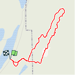
Trail Walking of 4.8 km to be discovered at Quebec, Les Laurentides, Labelle. This trail is proposed by Alizée.pee.
Description
c’est un sentier très sympathique avec plusieurs points de vue sur gros rocher, sur les montagnes ainsi que les lacs environnants. C’est une randonnée assez courte, facile à faire avec des enfants. La piste avait de nombreux belvédères magnifiques. Se situe près de Labelle.
Positioning
Country:
Canada
Region :
Quebec
Department/Province :
Les Laurentides
Municipality :
Labelle
Location:
Unknown
Start:(Dec)
Start:(UTM)
524453 ; 5121975 (18T) N.
Comments
Trails nearby
![Trail Walking Labelle - Wikiloc - Montagne verte et nez de l'indien - Photo](https://media.geolcdn.com/t/375/260/ext.jpg?maxdim=2&url=https%3A%2F%2Fstatic1.geolcdn.com%2Fsiteimages%2Fupload%2Ffiles%2F1553511878bg_sport_marche.png)
![Walking Walking](https://static1.geolcdn.com/sitytour/trail-icons/101.png)
Wikiloc - Montagne verte et nez de l'indien
Walking
Difficult
Labelle,
Quebec,
Les Laurentides,
Canada
![](/images/other/stat-length.png)
12.4 km | 21 km-effort
4h 14min
![](https://static1.geolcdn.com/siteimages/upload/files/16400158638029165_repeat_loop_refresh_sync_direction_icon.png)
Yes
![Trail Canoe - kayak Labelle - Rivière Rouge - Photo](https://media.geolcdn.com/t/375/260/ext.jpg?maxdim=2&url=https%3A%2F%2Fsecurestorage.geolives.com%2Fsitytour%2Ftrail-bg%2Fdefault.jpg)
![Canoe - kayak Canoe - kayak](https://static1.geolcdn.com/sitytour/trail-icons/703.png)
Rivière Rouge
Canoe - kayak
Medium
Labelle,
Quebec,
Les Laurentides,
Canada
![](/images/other/stat-length.png)
25 km | 27 km-effort
4h 10min
![](https://static1.geolcdn.com/siteimages/upload/files/16400158638029165_repeat_loop_refresh_sync_direction_icon.png)
No