Trail Walking Saint-Ferréol-les-Neiges - Trail Planner Map - Photo
 Alizée.pee
Alizée.pee

User GUIDE

© OpenStreetMap contributors
Length
Length
22 km
Max alt
Max alt
300 m
Uphill gradient
Uphill gradient
947 m
Km-Effort
Km-Effort  
34 km
Min alt
Min alt
64 m
Downhill gradient
Downhill gradient
947 m
Boucle
Boucle
Yes
Creation date :
2019-09-06 13:35:58.783
Updated on :
2019-09-06 13:36:31.681

(0 Reviews)

Walking
Walking
7h02
Difficulty : Difficult

Scan this QR Code to open this trail in the SityTrail application

FREE GPS app for hiking

Logo SityTrail SityTrail

IGN / Geographical institutes

Download SityTrail from the App Store Download SityTrail from Google Play

Logo SityTrail SityTrail World

The world is yours!

Download SityTrail from the App Store Download SityTrail from Google Play Download SityTrail on Huawei AppGallery

About

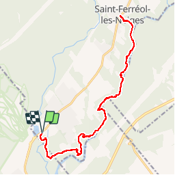
Trail Walking of 22 km to be discovered at Quebec, La Côte-de-Beaupré, Saint-Ferréol-les-Neiges. This trail is proposed by Alizée.pee.

Description

C’est une belle randonnée, à ne pas sous-estimer. Il y a des beaux points de vue sur une rivière. Le sentier passe par de jolis ponts avec de magnifiques paysages. De plus, cette randonnée comporte une cascade. Nous avons vraiment bien apprécié cette randonnée quoi que un peu difficile.

Elevation profile

Positioning

Country:
Canada
Region :
Quebec
Department/Province :
La Côte-de-Beaupré
Municipality :
Saint-Ferréol-les-Neiges
Location:
Unknown
Start:(UTM)
355860 ; 5215498 (19T) N.

Trails nearby

Trail Walking Beaupré - Wikiloc - Québec Mont Saint Anne Juillet 2004 - Photo
Walking
GUIDE
Alizée.pee

Walking

Difficult
Beaupré, Quebec, La Côte-de-Beaupré, Canada
7.4 km | 15.8 km-effort
3h 6min
Yes


Close
My subscriptions