![](/images/other/stat-length.png)
![Trail Walking Sainte-Lucie-des-Laurentides - Trail Planner Map - Photo](https://media.geolcdn.com/t/1900/400/ext.pjpeg?maxdim=2&url=https%3A%2F%2Fstatic1.geolcdn.com%2Fsiteimages%2Fupload%2Ffiles%2F1553511878bg_sport_marche.png)
Trail Planner Map
Alizée.pee
User GUIDE
![Length](/images/other/stat-length.png)
Length
5.8 km
![Max alt](https://static1.geolcdn.com/siteimages/upload/files/1508320355ic_sort_altitude_max_24dp.png)
Max alt
827 m
![Uphill gradient](https://static1.geolcdn.com/siteimages/upload/files/1508320355ic_sort_den_pos_24dp.png)
Uphill gradient
357 m
![Km-Effort](/images/other/stat-length.png)
Km-Effort
10.6 km
![Min alt](https://static1.geolcdn.com/siteimages/upload/files/1508320355ic_sort_altitude_min_24dp.png)
Min alt
483 m
![Downhill gradient](https://static1.geolcdn.com/siteimages/upload/files/1508320355ic_sort_den_neg_24dp.png)
Downhill gradient
357 m
![Boucle](https://static1.geolcdn.com/siteimages/upload/files/16400158638029165_repeat_loop_refresh_sync_direction_icon.png)
Boucle
Yes
Creation date :
2019-09-06 12:50:16.149
Updated on :
2019-09-06 12:50:54.346
![Walking](https://static1.geolcdn.com/sitytour/trail-icons/101.png)
2h07
Difficulty : Medium
![Scan this QR Code to open this trail in the SityTrail application](https://capi.geolives.com/qq0zvz2zws4bq2lad0pu/sitytour/trails/2193306/qr.png?size=200)
FREE GPS app for hiking
About
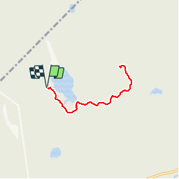
Trail Walking of 5.8 km to be discovered at Quebec, Les Laurentides, Sainte-Lucie-des-Laurentides. This trail is proposed by Alizée.pee.
Description
Le sentier du Mont Kaaikop se situe près de Sainte-Lucie-Des-Laurentides. La randonnée est magnifique, avec une montée dès le début du sentier, avec un beau point de vue au sommet. Elle est assez courte mais possède de magnifiques paysages.
Positioning
Country:
Canada
Region :
Quebec
Department/Province :
Les Laurentides
Municipality :
Sainte-Lucie-des-Laurentides
Location:
Unknown
Start:(Dec)
Start:(UTM)
561133 ; 5119290 (18T) N.
Comments
Trails nearby
![Trail Walking Notre-Dame-de-la-Merci - Mont Ouareau - Photo](https://media.geolcdn.com/t/375/260/ext.jpg?maxdim=2&url=https%3A%2F%2Fstatic1.geolcdn.com%2Fsiteimages%2Fupload%2Ffiles%2F1553511878bg_sport_marche.png)
![Walking Walking](https://static1.geolcdn.com/sitytour/trail-icons/101.png)
Mont Ouareau
Walking
Medium
Notre-Dame-de-la-Merci,
Quebec,
Matawinie,
Canada
![](/images/other/stat-length.png)
5.3 km | 9.2 km-effort
1h 52min
![](https://static1.geolcdn.com/siteimages/upload/files/16400158638029165_repeat_loop_refresh_sync_direction_icon.png)
Yes
![Trail Walking Notre-Dame-de-la-Merci - Wikiloc - Lanaudière - Parc régionale de la Forêt Ouareau - Sentier de... - Photo](https://media.geolcdn.com/t/375/260/ext.jpg?maxdim=2&url=https%3A%2F%2Fstatic1.geolcdn.com%2Fsiteimages%2Fupload%2Ffiles%2F1553511878bg_sport_marche.png)
![Walking Walking](https://static1.geolcdn.com/sitytour/trail-icons/101.png)
Wikiloc - Lanaudière - Parc régionale de la Forêt Ouareau - Sentier de...
Walking
Difficult
Notre-Dame-de-la-Merci,
Quebec,
Matawinie,
Canada
![](/images/other/stat-length.png)
11.5 km | 13.2 km-effort
2h 54min
![](https://static1.geolcdn.com/siteimages/upload/files/16400158638029165_repeat_loop_refresh_sync_direction_icon.png)
Yes
![Trail Walking Lac-Supérieur - Wikiloc - Mont Nixon - Lac Supérieur - Photo](https://media.geolcdn.com/t/375/260/ext.jpg?maxdim=2&url=https%3A%2F%2Fstatic1.geolcdn.com%2Fsiteimages%2Fupload%2Ffiles%2F1553511878bg_sport_marche.png)
![Walking Walking](https://static1.geolcdn.com/sitytour/trail-icons/101.png)
Wikiloc - Mont Nixon - Lac Supérieur
Walking
Difficult
Lac-Supérieur,
Quebec,
Les Laurentides,
Canada
![](/images/other/stat-length.png)
8.7 km | 14.6 km-effort
2h 59min
![](https://static1.geolcdn.com/siteimages/upload/files/16400158638029165_repeat_loop_refresh_sync_direction_icon.png)
Yes
![Trail Walking Saint-Donat-de-Montcalm - Wikiloc - Sentier de la Baie de l'Ours - cap de la fée, St-Donat - Photo](https://media.geolcdn.com/t/375/260/ext.jpg?maxdim=2&url=https%3A%2F%2Fstatic1.geolcdn.com%2Fsiteimages%2Fupload%2Ffiles%2F1553511878bg_sport_marche.png)
![Walking Walking](https://static1.geolcdn.com/sitytour/trail-icons/101.png)
Wikiloc - Sentier de la Baie de l'Ours - cap de la fée, St-Donat
Walking
Medium
Saint-Donat-de-Montcalm,
Quebec,
Matawinie,
Canada
![](/images/other/stat-length.png)
7.3 km | 10.5 km-effort
2h 12min
![](https://static1.geolcdn.com/siteimages/upload/files/16400158638029165_repeat_loop_refresh_sync_direction_icon.png)
Yes
![Trail Walking Notre-Dame-de-la-Merci - Wikiloc - Contreforts - Photo](https://media.geolcdn.com/t/375/260/ext.jpg?maxdim=2&url=https%3A%2F%2Fstatic1.geolcdn.com%2Fsiteimages%2Fupload%2Ffiles%2F1553511878bg_sport_marche.png)
![Walking Walking](https://static1.geolcdn.com/sitytour/trail-icons/101.png)
Wikiloc - Contreforts
Walking
Medium
Notre-Dame-de-la-Merci,
Quebec,
Matawinie,
Canada
![](/images/other/stat-length.png)
5.5 km | 8.4 km-effort
1h 44min
![](https://static1.geolcdn.com/siteimages/upload/files/16400158638029165_repeat_loop_refresh_sync_direction_icon.png)
Yes