Trail Walking Sutton - Trail Planner Map - Photo

Trail Planner Map

 Alizée.pee
Alizée.pee

User GUIDE

© OpenStreetMap contributors
Length
Length
7 km
Max alt
Max alt
950 m
Uphill gradient
Uphill gradient
430 m
Km-Effort
Km-Effort  
12.8 km
Min alt
Min alt
519 m
Downhill gradient
Downhill gradient
431 m
Boucle
Boucle
Yes
Creation date :
2019-09-06 09:32:32.813
Updated on :
2019-09-06 09:33:33.139

(0 Reviews)

Walking
Walking
2h34
Difficulty : Medium

Scan this QR Code to open this trail in the SityTrail application

FREE GPS app for hiking

Logo SityTrail SityTrail

IGN / Geographical institutes

Download SityTrail from the App Store Download SityTrail from Google Play

Logo SityTrail SityTrail World

The world is yours!

Download SityTrail from the App Store Download SityTrail from Google Play Download SityTrail on Huawei AppGallery

About

Trail Walking of 7 km to be discovered at Quebec, Brome-Missisquoi, Sutton. This trail is proposed by Alizée.pee.

Description

Belle randonnée, pas trop difficile, avec beaucoup de roches et de racines et avec une vue au sommet qui est à couper le souffle ! Il y a des points de vue tout au long du parcours ! De beaux paysages sur un lac. Super agréable, je recommande cette randonnée.

Elevation profile

Positioning

Country:
Canada
Region :
Quebec
Department/Province :
Brome-Missisquoi
Municipality :
Sutton
Location:
Unknown
Start:(UTM)
692860 ; 4996639 (18T) N.

Trails nearby

Trail Canoe - kayak Potton - Rivière Missisquoi Mansonville à Glenn Sutton - Photo
Canoe - kayak
DaVinci

Canoe - kayak

Medium
Potton, Quebec, Memphrémagog, Canada
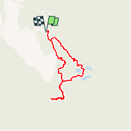
17.8 km | 19.3 km-effort
2h 55min
No


Close
My subscriptions