Trail Walking Sault-au-Cochon - Sentier Des Caps - Photo
 Alizée.pee
Alizée.pee

User GUIDE

© OpenStreetMap contributors
Length
Length
31 km
Max alt
Max alt
710 m
Uphill gradient
Uphill gradient
1488 m
Km-Effort
Km-Effort  
51 km
Min alt
Min alt
349 m
Downhill gradient
Downhill gradient
1488 m
Boucle
Boucle
Yes
Creation date :
2019-09-06 09:04:05.781
Updated on :
2019-09-06 09:07:20.714

(0 Reviews)

Walking
Walking
10h00
Difficulty : Difficult

Scan this QR Code to open this trail in the SityTrail application

FREE GPS app for hiking

Logo SityTrail SityTrail

IGN / Geographical institutes

Download SityTrail from the App Store Download SityTrail from Google Play

Logo SityTrail SityTrail World

The world is yours!

Download SityTrail from the App Store Download SityTrail from Google Play Download SityTrail on Huawei AppGallery

About

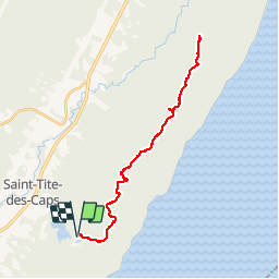
Trail Walking of 31 km to be discovered at Quebec, La Côte-de-Beaupré, Sault-au-Cochon. This trail is proposed by Alizée.pee.

Description

Grand sentier le long du fleuve Saint-Laurent. Les vues sont incroyables et surprenantes. Le sentier est tout aussi praticable en été et en hiver. Randonnée avec un sentier bien balisé. Malgré le fait que cette randonnée soit assez longue, avec des possibilités de raccourcir, le paysage est splendide du début à la fin.

Elevation profile

Positioning

Country:
Canada
Region :
Quebec
Department/Province :
La Côte-de-Beaupré
Municipality :
Sault-au-Cochon
Location:
Unknown
Start:(UTM)
367878 ; 5220278 (19T) N.

Trails nearby

Trail Walking Saint-Ferréol-les-Neiges - Trail Planner Map - Photo
Walking
GUIDE
Alizée.pee

Walking

Difficult
Saint-Ferréol-les-Neiges, Quebec, La Côte-de-Beaupré, Canada
22 km | 34 km-effort
7h 2min
Yes
Trail Walking Beaupré - Wikiloc - Québec Mont Saint Anne Juillet 2004 - Photo
Walking
GUIDE
Alizée.pee

Walking

Difficult
Beaupré, Quebec, La Côte-de-Beaupré, Canada
7.4 km | 15.8 km-effort
3h 6min
Yes


Close
My subscriptions