![](/images/other/stat-length.png)
![Trail Walking Beuzec-Cap-Sizun - Pointe du Millier - GR34 Réserve Naturelle de Goulien - 19.2km 540m520 6h20 (45mn) - 2019 09 05 - Photo](https://media.geolcdn.com/t/1900/400/f9adb3f6-de16-4809-b882-c58b1570812d.jpg&format=pjpeg&maxdim=2)
Pointe du Millier - GR34 Réserve Naturelle de Goulien - 19.2km 540m520 6h20 (45mn) - 2019 09 05
Orcal37
User GUIDE
![Length](/images/other/stat-length.png)
Length
19.2 km
![Max alt](https://static1.geolcdn.com/siteimages/upload/files/1508320355ic_sort_altitude_max_24dp.png)
Max alt
72 m
![Uphill gradient](https://static1.geolcdn.com/siteimages/upload/files/1508320355ic_sort_den_pos_24dp.png)
Uphill gradient
541 m
![Km-Effort](/images/other/stat-length.png)
Km-Effort
26 km
![Min alt](https://static1.geolcdn.com/siteimages/upload/files/1508320355ic_sort_altitude_min_24dp.png)
Min alt
0 m
![Downhill gradient](https://static1.geolcdn.com/siteimages/upload/files/1508320355ic_sort_den_neg_24dp.png)
Downhill gradient
522 m
![Boucle](https://static1.geolcdn.com/siteimages/upload/files/16400158638029165_repeat_loop_refresh_sync_direction_icon.png)
Boucle
No
Creation date :
2019-09-05 08:34:51.451
Updated on :
2021-09-19 17:25:17.924
![Walking](https://static1.geolcdn.com/sitytour/trail-icons/101.png)
6h20
Difficulty : Medium
![Scan this QR Code to open this trail in the SityTrail application](https://capi.geolives.com/qq0zvz2zws4bq2lad0pu/sitytour/trails/2192781/qr.png?size=200)
FREE GPS app for hiking
About
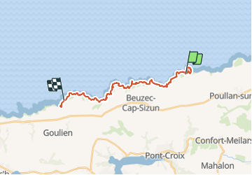
Trail Walking of 19.2 km to be discovered at Brittany, Finistère, Beuzec-Cap-Sizun. This trail is proposed by Orcal37.
Description
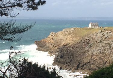
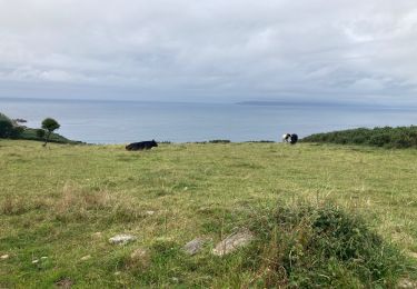
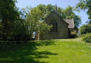
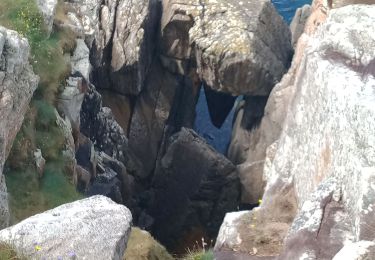
Pointe du Millier - Moulin puis GR34 jusqu'à la Réserve Naturelle de Goulien-Cap Sizun (16km de parking à parking - 19.2km 540m520 6h20 (45mn) - 2019 09 05
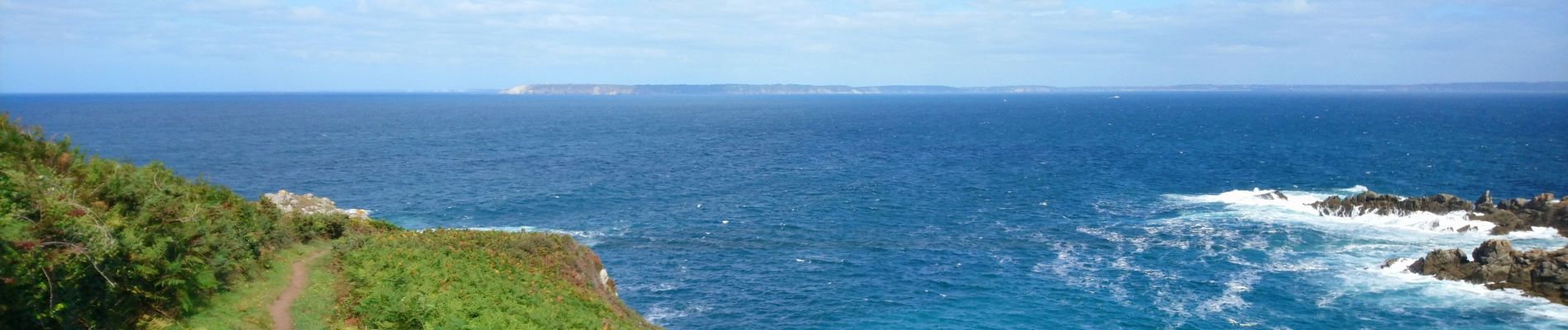
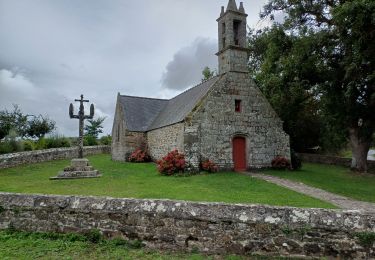
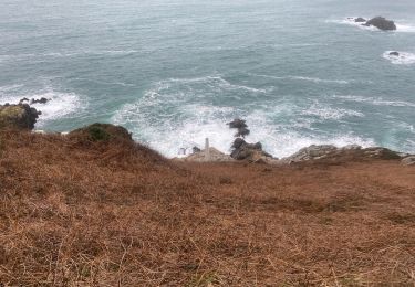
Positioning
Country:
France
Region :
Brittany
Department/Province :
Finistère
Municipality :
Beuzec-Cap-Sizun
Location:
Unknown
Start:(Dec)
Start:(UTM)
390732 ; 5327835 (30U) N.
Comments
Trails nearby
![Trail Walking Beuzec-Cap-Sizun - GR34 Pors Péron -- Cléden-Cap-Sizun - Photo](https://media.geolcdn.com/t/375/260/2400bb12-0ba1-4b3d-8384-f73cf33894c6.jpg&format=jpg&maxdim=2)
![Walking Walking](https://static1.geolcdn.com/sitytour/trail-icons/101.png)
GR34 Pors Péron -- Cléden-Cap-Sizun
Walking
Very difficult
Beuzec-Cap-Sizun,
Brittany,
Finistère,
France
![](/images/other/stat-length.png)
17.8 km | 21 km-effort
4h 44min
![](https://static1.geolcdn.com/siteimages/upload/files/16400158638029165_repeat_loop_refresh_sync_direction_icon.png)
No
![Trail Walking Beuzec-Cap-Sizun - TREK RCY GR34 2022 J3 Beuzec-Audierne - Photo](https://media.geolcdn.com/t/375/260/b71b2c0f-f009-4948-9a20-6fa2a3eeed04.jpg&format=jpg&maxdim=2)
![Walking Walking](https://static1.geolcdn.com/sitytour/trail-icons/101.png)
TREK RCY GR34 2022 J3 Beuzec-Audierne
Walking
Very easy
Beuzec-Cap-Sizun,
Brittany,
Finistère,
France
![](/images/other/stat-length.png)
18.4 km | 22 km-effort
4h 43min
![](https://static1.geolcdn.com/siteimages/upload/files/16400158638029165_repeat_loop_refresh_sync_direction_icon.png)
No
![Trail Walking Beuzec-Cap-Sizun - Beuzec falaise beuzec - Photo](https://media.geolcdn.com/t/375/260/2cc82130-6bac-410f-ad69-2508c942b5f3.jpg&format=jpg&maxdim=2)
![Walking Walking](https://static1.geolcdn.com/sitytour/trail-icons/101.png)
Beuzec falaise beuzec
Walking
Difficult
Beuzec-Cap-Sizun,
Brittany,
Finistère,
France
![](/images/other/stat-length.png)
13.7 km | 17.5 km-effort
3h 57min
![](https://static1.geolcdn.com/siteimages/upload/files/16400158638029165_repeat_loop_refresh_sync_direction_icon.png)
Yes
![Trail Walking Beuzec-Cap-Sizun - Pointe millier - Photo](https://media.geolcdn.com/t/375/260/ca4edc39-cd65-4499-aa1a-d66fd8bd4925.jpg&format=jpg&maxdim=2)
![Walking Walking](https://static1.geolcdn.com/sitytour/trail-icons/101.png)
Pointe millier
Walking
Easy
Beuzec-Cap-Sizun,
Brittany,
Finistère,
France
![](/images/other/stat-length.png)
8.2 km | 10.4 km-effort
3h 5min
![](https://static1.geolcdn.com/siteimages/upload/files/16400158638029165_repeat_loop_refresh_sync_direction_icon.png)
Yes
![Trail Walking Beuzec-Cap-Sizun - Pors peron - Photo](https://media.geolcdn.com/t/375/260/60dd7971-53fd-4068-a479-adadb6620e7a.jpg&format=jpg&maxdim=2)
![Walking Walking](https://static1.geolcdn.com/sitytour/trail-icons/101.png)
Pors peron
Walking
Very easy
Beuzec-Cap-Sizun,
Brittany,
Finistère,
France
![](/images/other/stat-length.png)
5 km | 6.2 km-effort
1h 36min
![](https://static1.geolcdn.com/siteimages/upload/files/16400158638029165_repeat_loop_refresh_sync_direction_icon.png)
Yes
![Trail Walking Beuzec-Cap-Sizun - Beuzec-Cap-Sizun - Photo](https://media.geolcdn.com/t/375/260/e49dede0-2e8b-44a7-93fa-d2f6988dcadd.jpg&format=jpg&maxdim=2)
![Walking Walking](https://static1.geolcdn.com/sitytour/trail-icons/101.png)
Beuzec-Cap-Sizun
Walking
Easy
Beuzec-Cap-Sizun,
Brittany,
Finistère,
France
![](/images/other/stat-length.png)
10.8 km | 13.5 km-effort
3h 39min
![](https://static1.geolcdn.com/siteimages/upload/files/16400158638029165_repeat_loop_refresh_sync_direction_icon.png)
Yes
![Trail Walking Beuzec-Cap-Sizun - BEUZEC CAP SIZUN - Photo](https://media.geolcdn.com/t/375/260/ba6b4ce8-12be-4b74-b661-6ea0bf8543d7.jpg&format=jpg&maxdim=2)
![Walking Walking](https://static1.geolcdn.com/sitytour/trail-icons/101.png)
BEUZEC CAP SIZUN
Walking
Medium
Beuzec-Cap-Sizun,
Brittany,
Finistère,
France
![](/images/other/stat-length.png)
21 km | 25 km-effort
5h 16min
![](https://static1.geolcdn.com/siteimages/upload/files/16400158638029165_repeat_loop_refresh_sync_direction_icon.png)
Yes
![Trail On foot Beuzec-Cap-Sizun - GR34 Pors Péron -- Cléden-Cap-Sizun - Photo](https://media.geolcdn.com/t/375/260/ext.jpg?maxdim=2&url=https%3A%2F%2Fstatic1.geolcdn.com%2Fsiteimages%2Fupload%2Ffiles%2F1545311037marcheuse_200dpi.jpg)
![On foot On foot](https://static1.geolcdn.com/sitytour/trail-icons/100.png)
GR34 Pors Péron -- Cléden-Cap-Sizun
On foot
Difficult
Beuzec-Cap-Sizun,
Brittany,
Finistère,
France
![](/images/other/stat-length.png)
25 km | 34 km-effort
7h 37min
![](https://static1.geolcdn.com/siteimages/upload/files/16400158638029165_repeat_loop_refresh_sync_direction_icon.png)
No
![Trail Walking Poullan-sur-Mer - POULLAN SUR MER - Photo](https://media.geolcdn.com/t/375/260/10c286a2-bf65-4737-bb24-f919722f0caa.jpg&format=jpg&maxdim=2)
![Walking Walking](https://static1.geolcdn.com/sitytour/trail-icons/101.png)
POULLAN SUR MER
Walking
Difficult
Poullan-sur-Mer,
Brittany,
Finistère,
France
![](/images/other/stat-length.png)
23 km | 27 km-effort
5h 36min
![](https://static1.geolcdn.com/siteimages/upload/files/16400158638029165_repeat_loop_refresh_sync_direction_icon.png)
Yes