Trail Walking Saint-Philémon - Gates of Hell Trail  - Photo

Gates of Hell Trail

 Alizée.pee
Alizée.pee

User GUIDE

© OpenStreetMap contributors
Length
Length
15.5 km
Max alt
Max alt
820 m
Uphill gradient
Uphill gradient
708 m
Km-Effort
Km-Effort  
25 km
Min alt
Min alt
443 m
Downhill gradient
Downhill gradient
708 m
Boucle
Boucle
Yes
Creation date :
2019-09-05 14:48:07.505
Updated on :
2019-09-05 14:49:23.562

(0 Reviews)

Walking
Walking
5h07
Difficulty : Difficult

Scan this QR Code to open this trail in the SityTrail application

FREE GPS app for hiking

Logo SityTrail SityTrail

IGN / Geographical institutes

Download SityTrail from the App Store Download SityTrail from Google Play

Logo SityTrail SityTrail World

The world is yours!

Download SityTrail from the App Store Download SityTrail from Google Play Download SityTrail on Huawei AppGallery

About

Trail Walking of 15.5 km to be discovered at Quebec, Bellechasse, Saint-Philémon. This trail is proposed by Alizée.pee.

Description

Sentier assez difficile mais qui en vaut la peine. C’est une randonnée qui traverse le parc régional du Massif du Sud et qui est très agréable. À un moment donné, une petite rivière descend un canyon. La végétation et les paysages sont incroyables. Très beau sentier !  

Elevation profile

Positioning

Country:
Canada
Region :
Quebec
Department/Province :
Bellechasse
Municipality :
Saint-Philémon
Location:
Unknown
Start:(UTM)
387765 ; 5164996 (19T) N.

Trails nearby

Trail Walking Saint-Philémon - Wikiloc - Chaudière-Appalaches - Parc régional du Massif du Sud - Sent... - Photo
Walking
GUIDE
Alizée.pee

Walking

Medium
Saint-Philémon, Quebec, Bellechasse, Canada
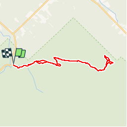
7.4 km | 11.3 km-effort
2h 20min
Yes


Close
My subscriptions