Trail Walking Saint-Zénon - Trail Planner Map - Photo

Trail Planner Map

 Alizée.pee
Alizée.pee

User GUIDE

© OpenStreetMap contributors
Length
Length
10.5 km
Max alt
Max alt
651 m
Uphill gradient
Uphill gradient
495 m
Km-Effort
Km-Effort  
17.1 km
Min alt
Min alt
389 m
Downhill gradient
Downhill gradient
494 m
Boucle
Boucle
Yes
Creation date :
2019-09-05 14:09:42.988
Updated on :
2019-09-05 14:13:28.714

(0 Reviews)

Walking
Walking
3h31
Difficulty : Difficult

Scan this QR Code to open this trail in the SityTrail application

FREE GPS app for hiking

Logo SityTrail SityTrail

IGN / Geographical institutes

Download SityTrail from the App Store Download SityTrail from Google Play

Logo SityTrail SityTrail World

The world is yours!

Download SityTrail from the App Store Download SityTrail from Google Play Download SityTrail on Huawei AppGallery

About

Trail Walking of 10.5 km to be discovered at Quebec, Matawinie, Saint-Zénon. This trail is proposed by Alizée.pee.

Description

Cette randonnée en boucle fait le tour du parc régional des Sept-Chutes. Malgré sa difficulté, le sentier offre de magnifiques paysages, une végétation qui change au fur et à mesure de la randonnée, plusieurs chutes d’eau ainsi qu’un magnifique lac. Il est possible de se baigner dans le lac Rémi si le temps vous le permet. De beaux points de vue sont disponibles durant la randonnée. À couper le souffle !

Elevation profile

Positioning

Country:
Canada
Region :
Quebec
Department/Province :
Matawinie
Municipality :
Saint-Zénon
Location:
Unknown
Start:(Dec)
Start:(UTM)
598275 ; 5146799 (18T) N.

Trails nearby

Trail Walking Saint-Zénon - Trail Planner Map - Photo
Walking
GUIDE
Alizée.pee

Walking

Medium
Saint-Zénon, Quebec, Matawinie, Canada
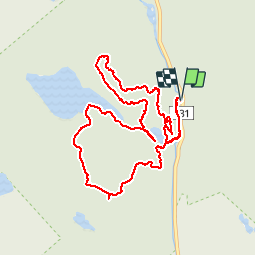
6.3 km | 10.3 km-effort
2h 6min
Yes
Trail Walking Saint-Zénon - Wikiloc - Parc Régional des Sept-Chutes  - Photo
Walking
GUIDE
Alizée.pee

Walking

Difficult
Saint-Zénon, Quebec, Matawinie, Canada
10.5 km | 16.3 km-effort
3h 22min
Yes
Trail Walking Saint-Zénon - Wikiloc - Lanaudière - Parc rég. Sept-Chutes de Saint-Zénon - Mont Brassard - Rando-Québec - Photo
Walking
GUIDE
Alizée.pee

Walking

Medium
Saint-Zénon, Quebec, Matawinie, Canada
6.4 km | 10.5 km-effort
2h 9min
Yes


Close
My subscriptions