Trail Walking Saint-Michel-du-Squatec - Trail Planner Map - Photo
 Alizée.pee
Alizée.pee

User GUIDE

© OpenStreetMap contributors
Length
Length
5.3 km
Max alt
Max alt
347 m
Uphill gradient
Uphill gradient
184 m
Km-Effort
Km-Effort  
7.7 km
Min alt
Min alt
172 m
Downhill gradient
Downhill gradient
184 m
Boucle
Boucle
Yes
Creation date :
2019-09-05 13:23:35.8
Updated on :
2019-09-05 13:24:28.326

(0 Reviews)

Walking
Walking
1h36
Difficulty : Medium

Scan this QR Code to open this trail in the SityTrail application

FREE GPS app for hiking

Logo SityTrail SityTrail

IGN / Geographical institutes

Download SityTrail from the App Store Download SityTrail from Google Play

Logo SityTrail SityTrail World

The world is yours!

Download SityTrail from the App Store Download SityTrail from Google Play Download SityTrail on Huawei AppGallery

About

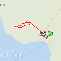
Trail Walking of 5.3 km to be discovered at Quebec, Témiscouata, Saint-Michel-du-Squatec. This trail is proposed by Alizée.pee.

Description

Ce sentier en boucle est peu connu mais possède de magnifiques paysages et surtout de belles vues sur le lac Témiscouata. Le dénivelé n’est pas trop élevé mais cela n’empêche que le sentier fourni de beaux paysages tout au long de la randonnée.

Elevation profile

Positioning

Country:
Canada
Region :
Quebec
Department/Province :
Témiscouata
Municipality :
Saint-Michel-du-Squatec
Location:
Unknown
Start:(UTM)
511773 ; 5282711 (19T) N.

Trails nearby


Close
My subscriptions