Trail Walking East Hereford - Trail Planner Map - Photo
 Alizée.pee
Alizée.pee

User GUIDE

© OpenStreetMap contributors
Length
Length
10.9 km
Max alt
Max alt
865 m
Uphill gradient
Uphill gradient
490 m
Km-Effort
Km-Effort  
17.4 km
Min alt
Min alt
391 m
Downhill gradient
Downhill gradient
490 m
Boucle
Boucle
Yes
Creation date :
2019-09-05 13:12:27.373
Updated on :
2019-09-05 13:13:29.151

(0 Reviews)

Walking
Walking
3h35
Difficulty : Difficult

Scan this QR Code to open this trail in the SityTrail application

FREE GPS app for hiking

Logo SityTrail SityTrail

IGN / Geographical institutes

Download SityTrail from the App Store Download SityTrail from Google Play

Logo SityTrail SityTrail World

The world is yours!

Download SityTrail from the App Store Download SityTrail from Google Play Download SityTrail on Huawei AppGallery

About

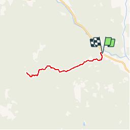
Trail Walking of 10.9 km to be discovered at Quebec, Coaticook (MRC), East Hereford. This trail is proposed by Alizée.pee.

Description

Le sentier passe par une belle forêt mixte, longeant un ruisseau que vous traverserez plusieurs fois ainsi qu’une magnifique cascade et les chutes de Donat. Il y a de très belles vues durant la randonnée sur la forêt Hereford et les montagnes américaines. Au sommet, un magnifique panorama sur 360 degrés vous attend. N’hésitez pas à faire cette randonnée, vous en aurez des souvenirs pleins les yeux.

Elevation profile

Positioning

Country:
Canada
Region :
Quebec
Department/Province :
Coaticook (MRC)
Municipality :
East Hereford
Location:
Unknown
Start:(UTM)
299348 ; 4996332 (19T) N.

Trails nearby


Close
My subscriptions