![](/images/other/stat-length.png)
![Trail Walking Lac-Croche - Trail Planner Map - Photo](https://media.geolcdn.com/t/1900/400/ext.pjpeg?maxdim=2&url=https%3A%2F%2Fstatic1.geolcdn.com%2Fsiteimages%2Fupload%2Ffiles%2F1553511878bg_sport_marche.png)
Trail Planner Map
Alizée.pee
User GUIDE
![Length](/images/other/stat-length.png)
Length
15.8 km
![Max alt](https://static1.geolcdn.com/siteimages/upload/files/1508320355ic_sort_altitude_max_24dp.png)
Max alt
780 m
![Uphill gradient](https://static1.geolcdn.com/siteimages/upload/files/1508320355ic_sort_den_pos_24dp.png)
Uphill gradient
521 m
![Km-Effort](/images/other/stat-length.png)
Km-Effort
23 km
![Min alt](https://static1.geolcdn.com/siteimages/upload/files/1508320355ic_sort_altitude_min_24dp.png)
Min alt
280 m
![Downhill gradient](https://static1.geolcdn.com/siteimages/upload/files/1508320355ic_sort_den_neg_24dp.png)
Downhill gradient
521 m
![Boucle](https://static1.geolcdn.com/siteimages/upload/files/16400158638029165_repeat_loop_refresh_sync_direction_icon.png)
Boucle
Yes
Creation date :
2019-09-05 11:46:54.453
Updated on :
2019-09-05 11:47:51.077
![Walking](https://static1.geolcdn.com/sitytour/trail-icons/101.png)
4h46
Difficulty : Difficult
![Scan this QR Code to open this trail in the SityTrail application](https://capi.geolives.com/qq0zvz2zws4bq2lad0pu/sitytour/trails/2192297/qr.png?size=200)
FREE GPS app for hiking
About
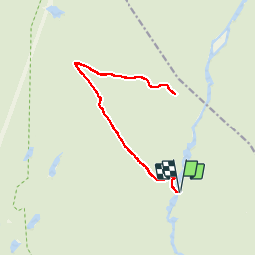
Trail Walking of 15.8 km to be discovered at Quebec, La Jacques-Cartier, Lac-Croche. This trail is proposed by Alizée.pee.
Description
Cette randonnée se situe dans le parc national Jacques-Cartier. C’est un sentier qui passe par des lacs, de beaux étangs, … Il est en partie assez lisse, quelques parties plus rocheuses mais en général, le sentier est assez large. C’est assez ombragé et forestier.
Positioning
Country:
Canada
Region :
Quebec
Department/Province :
La Jacques-Cartier
Municipality :
Lac-Croche
Location:
Unknown
Start:(Dec)
Start:(UTM)
314363 ; 5243204 (19T) N.
Comments
Trails nearby
![Trail Walking Lac-Croche - Le Scotora - Photo](https://media.geolcdn.com/t/375/260/ext.jpg?maxdim=2&url=https%3A%2F%2Fstatic1.geolcdn.com%2Fsiteimages%2Fupload%2Ffiles%2F1553511878bg_sport_marche.png)
![Walking Walking](https://static1.geolcdn.com/sitytour/trail-icons/101.png)
Le Scotora
Walking
Medium
Lac-Croche,
Quebec,
La Jacques-Cartier,
Canada
![](/images/other/stat-length.png)
15.9 km | 23 km-effort
4h 51min
![](https://static1.geolcdn.com/siteimages/upload/files/16400158638029165_repeat_loop_refresh_sync_direction_icon.png)
Yes
![Trail Canoe - kayak Lac-Croche - Rivière Jacques Cartier - Photo](https://media.geolcdn.com/t/375/260/ext.jpg?maxdim=2&url=https%3A%2F%2Fsecurestorage.geolives.com%2Fsitytour%2Ftrail-bg%2Fdefault.jpg)
![Canoe - kayak Canoe - kayak](https://static1.geolcdn.com/sitytour/trail-icons/703.png)
Rivière Jacques Cartier
Canoe - kayak
Medium
Lac-Croche,
Quebec,
La Jacques-Cartier,
Canada
![](/images/other/stat-length.png)
25 km | 28 km-effort
4h 15min
![](https://static1.geolcdn.com/siteimages/upload/files/16400158638029165_repeat_loop_refresh_sync_direction_icon.png)
No
![Trail Walking Lac-Croche - Rando Stoneham-et-Tewkesbury Québec - Photo](https://media.geolcdn.com/t/375/260/ext.jpg?maxdim=2&url=https%3A%2F%2Fstatic1.geolcdn.com%2Fsiteimages%2Fupload%2Ffiles%2F1553511878bg_sport_marche.png)
![Walking Walking](https://static1.geolcdn.com/sitytour/trail-icons/101.png)
Rando Stoneham-et-Tewkesbury Québec
Walking
Very difficult
Lac-Croche,
Quebec,
La Jacques-Cartier,
Canada
![](/images/other/stat-length.png)
15.9 km | 23 km-effort
4h 48min
![](https://static1.geolcdn.com/siteimages/upload/files/16400158638029165_repeat_loop_refresh_sync_direction_icon.png)
Yes