![](/images/other/stat-length.png)
![Trail Walking Stoneham-et-Tewkesbury - Mont Wright Trail - Photo](https://media.geolcdn.com/t/1900/400/ext.pjpeg?maxdim=2&url=https%3A%2F%2Fstatic1.geolcdn.com%2Fsiteimages%2Fupload%2Ffiles%2F1553511878bg_sport_marche.png)
Mont Wright Trail
Alizée.pee
User GUIDE
![Length](/images/other/stat-length.png)
Length
5.8 km
![Max alt](https://static1.geolcdn.com/siteimages/upload/files/1508320355ic_sort_altitude_max_24dp.png)
Max alt
477 m
![Uphill gradient](https://static1.geolcdn.com/siteimages/upload/files/1508320355ic_sort_den_pos_24dp.png)
Uphill gradient
311 m
![Km-Effort](/images/other/stat-length.png)
Km-Effort
9.9 km
![Min alt](https://static1.geolcdn.com/siteimages/upload/files/1508320355ic_sort_altitude_min_24dp.png)
Min alt
195 m
![Downhill gradient](https://static1.geolcdn.com/siteimages/upload/files/1508320355ic_sort_den_neg_24dp.png)
Downhill gradient
311 m
![Boucle](https://static1.geolcdn.com/siteimages/upload/files/16400158638029165_repeat_loop_refresh_sync_direction_icon.png)
Boucle
Yes
Creation date :
2019-09-05 10:01:06.298
Updated on :
2019-09-05 10:01:49.22
![Walking](https://static1.geolcdn.com/sitytour/trail-icons/101.png)
2h01
Difficulty : Medium
![Scan this QR Code to open this trail in the SityTrail application](https://capi.geolives.com/qq0zvz2zws4bq2lad0pu/sitytour/trails/2192205/qr.png?size=200)
FREE GPS app for hiking
About
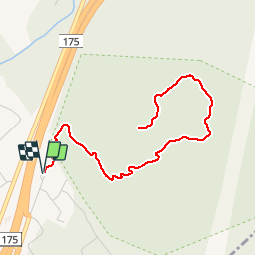
Trail Walking of 5.8 km to be discovered at Quebec, La Jacques-Cartier, Stoneham-et-Tewkesbury. This trail is proposed by Alizée.pee.
Description
Sentier qui présente un superbe environnement forestier et est considéré comme niveau moyen. La randonnée mène jusqu’au Mont Wright. Très belle randonnée avec des magnifiques paysages.
Positioning
Country:
Canada
Region :
Quebec
Department/Province :
La Jacques-Cartier
Municipality :
Stoneham-et-Tewkesbury
Location:
Unknown
Start:(Dec)
Start:(UTM)
321382 ; 5208787 (19T) N.
Comments
Trails nearby
![Trail Walking Stoneham-et-Tewkesbury - Boucle de la station Stoneham - Photo](https://media.geolcdn.com/t/375/260/ext.jpg?maxdim=2&url=https%3A%2F%2Fstatic1.geolcdn.com%2Fsiteimages%2Fupload%2Ffiles%2F1553511878bg_sport_marche.png)
![Walking Walking](https://static1.geolcdn.com/sitytour/trail-icons/101.png)
Boucle de la station Stoneham
Walking
Difficult
Stoneham-et-Tewkesbury,
Quebec,
La Jacques-Cartier,
Canada
![](/images/other/stat-length.png)
9.2 km | 15.1 km-effort
3h 5min
![](https://static1.geolcdn.com/siteimages/upload/files/16400158638029165_repeat_loop_refresh_sync_direction_icon.png)
Yes
![Trail Walking Stoneham-et-Tewkesbury - Mont Wright 2 - Photo](https://media.geolcdn.com/t/375/260/ext.jpg?maxdim=2&url=https%3A%2F%2Fstatic1.geolcdn.com%2Fsiteimages%2Fupload%2Ffiles%2F1553511878bg_sport_marche.png)
![Walking Walking](https://static1.geolcdn.com/sitytour/trail-icons/101.png)
Mont Wright 2
Walking
Stoneham-et-Tewkesbury,
Quebec,
La Jacques-Cartier,
Canada
![](/images/other/stat-length.png)
5.7 km | 9.4 km-effort
2h 22min
![](https://static1.geolcdn.com/siteimages/upload/files/16400158638029165_repeat_loop_refresh_sync_direction_icon.png)
Yes
![Trail Walking Stoneham-et-Tewkesbury - Mont Wright - Photo](https://media.geolcdn.com/t/375/260/ext.jpg?maxdim=2&url=https%3A%2F%2Fstatic1.geolcdn.com%2Fsiteimages%2Fupload%2Ffiles%2F1553511878bg_sport_marche.png)
![Walking Walking](https://static1.geolcdn.com/sitytour/trail-icons/101.png)
Mont Wright
Walking
Stoneham-et-Tewkesbury,
Quebec,
La Jacques-Cartier,
Canada
![](/images/other/stat-length.png)
6.5 km | 10.4 km-effort
3h 14min
![](https://static1.geolcdn.com/siteimages/upload/files/16400158638029165_repeat_loop_refresh_sync_direction_icon.png)
Yes