Trail Walking Unknown - 2215-06-06 16:12:40 - Photo
 Alizée.pee
Alizée.pee

User GUIDE

© OpenStreetMap contributors
Length
Length
4.9 km
Max alt
Max alt
864 m
Uphill gradient
Uphill gradient
276 m
Km-Effort
Km-Effort  
8.6 km
Min alt
Min alt
578 m
Downhill gradient
Downhill gradient
276 m
Boucle
Boucle
Yes
Creation date :
2019-09-04 14:47:17.213
Updated on :
2019-09-04 14:48:02.134

(0 Reviews)

Walking
Walking
1h44
Difficulty : Easy

Scan this QR Code to open this trail in the SityTrail application

FREE GPS app for hiking

Logo SityTrail SityTrail

IGN / Geographical institutes

Download SityTrail from the App Store Download SityTrail from Google Play

Logo SityTrail SityTrail World

The world is yours!

Download SityTrail from the App Store Download SityTrail from Google Play Download SityTrail on Huawei AppGallery

About

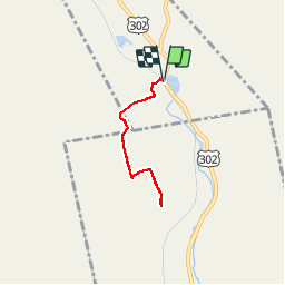
Trail Walking of 4.9 km to be discovered at New Hampshire, Coos County, Unknown. This trail is proposed by Alizée.pee.

Description

Courte randonnée qui permet de monter jusqu’au sommet du Mont Willard. Le sentier ne comporte pas de section difficile, possible à faire avec des enfants. Néanmoins, ce n’est pas parce que le sentier est facile que le paysage n’y est pas. Le sommet du Mont Willard offre une vue incroyable sur la vallée du Crawford Notch State Park. Bonne randonnée !

Elevation profile

Points of interest

Point of interest Unknown - Stationnement - Photo
Alizée.pee
UNKNOWN 
Point of interest Unknown - Sommet - Willard - Photo
Alizée.pee

Positioning

Country:
United States
Region :
New Hampshire
Department/Province :
Coos County
Municipality :
Unknown
Location:
Carroll
Start:(UTM)
307413 ; 4898853 (19T) N.

Trails nearby

Trail Walking Unknown - 2014-12-27 14:43:02 - Photo
Walking
GUIDE
Alizée.pee

Walking

Difficult
(1)
Unknown, New Hampshire, Coos County, United States
13.7 km | 27 km-effort
5h 19min
Yes


Close
My subscriptions