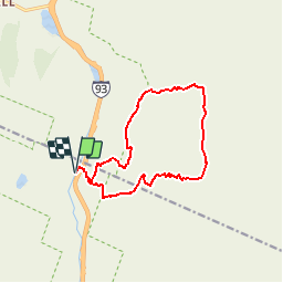
![](/images/other/stat-length.png)
![Trail Walking Unknown - ACTIVE LOG093503 - Photo](https://media.geolcdn.com/t/1900/400/ext.pjpeg?maxdim=2&url=https%3A%2F%2Fstatic1.geolcdn.com%2Fsiteimages%2Fupload%2Ffiles%2F1553511878bg_sport_marche.png)
ACTIVE LOG093503
Alizée.pee
User GUIDE
![Length](/images/other/stat-length.png)
![Max alt](https://static1.geolcdn.com/siteimages/upload/files/1508320355ic_sort_altitude_max_24dp.png)
![Uphill gradient](https://static1.geolcdn.com/siteimages/upload/files/1508320355ic_sort_den_pos_24dp.png)
![Km-Effort](/images/other/stat-length.png)
![Min alt](https://static1.geolcdn.com/siteimages/upload/files/1508320355ic_sort_altitude_min_24dp.png)
![Downhill gradient](https://static1.geolcdn.com/siteimages/upload/files/1508320355ic_sort_den_neg_24dp.png)
![Boucle](https://static1.geolcdn.com/siteimages/upload/files/16400158638029165_repeat_loop_refresh_sync_direction_icon.png)
![Walking](https://static1.geolcdn.com/sitytour/trail-icons/101.png)
5h39
Difficulty : Difficult
![Scan this QR Code to open this trail in the SityTrail application](https://capi.geolives.com/qq0zvz2zws4bq2lad0pu/sitytour/trails/2191602/qr.png?size=200)
FREE GPS app for hiking
About
Trail Walking of 13.6 km to be discovered at New Hampshire, Grafton County, Unknown. This trail is proposed by Alizée.pee.
Description
Cette randonnée traverse deux monts splendides, le Mont Lincoln et Lafayette. Le sentier passe par de jolis ruisseaux, ainsi que de magnifiques chutes d’eau. Il faut quand même prendre son temps car la montée est assez abrupte par endroit. Néanmoins, les deux sommets en valent la peine. Malgré le fait que ce sentier soit emprunté par de nombreux randonneurs, les panoramas qu’offre cette montagne sont à couper le souffle.
Positioning
Comments
Trails nearby
![Trail Walking Unknown - Mount Moosilauke - Photo](https://media.geolcdn.com/t/375/260/ext.jpg?maxdim=2&url=https%3A%2F%2Fstatic1.geolcdn.com%2Fsiteimages%2Fupload%2Ffiles%2F1553511878bg_sport_marche.png)
![Walking Walking](https://static1.geolcdn.com/sitytour/trail-icons/101.png)
Walking
![](/images/other/stat-length.png)
![](https://static1.geolcdn.com/siteimages/upload/files/16400158638029165_repeat_loop_refresh_sync_direction_icon.png)
Merci pour ce partage !